 view gallery view gallery SW2.6 km SW2.6 km
|   Le Moulin de Ranville - France Le Moulin de Ranville - France
in Millstones Adossées au mur de l'ancien moulin, en face du cimetière militaire, deux pierres de meule en pierre meulière.
Next to the wall of the old mill, in front of the military cemetery, two millstone stones of millstone. posted by:  Alfouine Alfouine location: Normandie, France date approved: 08/04/2017 last visited: 06/07/2021 |
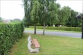 view gallery view gallerySW2.6 km |  Bench Dedicated to Airborne Soldiers - Ranville, Basse-Normandie, France Bench Dedicated to Airborne Soldiers - Ranville, Basse-Normandie, France
in Dedicated Benches A bench located across from Ranville War Cemetery that is dedicated to those from the Scottish Airborne. // Un banc situé en face du cimetière de guerre de Ranville qui est dédié à ceux de l'Airborne écossais. posted by: Trail Blaisers location: Normandie, France date approved: 07/13/2015 last visited: 03/28/2021 |
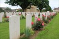 view gallery view gallerySW2.6 km |  Ranville War Cemetery - Ranville, Basse-Normandie, France Ranville War Cemetery - Ranville, Basse-Normandie, France
in Veteran Cemeteries Ranville is the final resting place of more than 2,200 Allied and 320 German soldiers. // Ranville est le lieu du dernier repos de plus de 2.200 Commonwealth et 320 soldats allemands. posted by: Trail Blaisers location: Normandie, France date approved: 07/13/2015 last visited: 03/28/2021 |
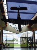
 view gallery view gallery W2.7 km W2.7 km
| ") Horsa Glider - Ranville, Normandie, France Horsa Glider - Ranville, Normandie, France
in Histoires de France (French historical markers) 318 planeurs HORSA ont atterri dans la région lors des opérations de la 6e division aéroportée britannique. Ils transportaient des hommes (30 maximum) ou du matériel (jeep et sa remarque, canon de 25 livres, motos, bicyclettes. posted by:  Don.Morfe Don.Morfe location: Normandie, France date approved: 08/01/2022 last visited: 07/30/2022 |
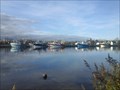 view gallery view gallery NW2.7 km NW2.7 km
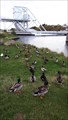
|  Le Port d'Ouistreham - Manche - Normandie - France Le Port d'Ouistreham - Manche - Normandie - France
in Commercial Fishing Ports [FR] De par sa situation, Ouistreham eut de tous temps une vocation maritime. [EN] Caen-Ouistreham, is home to smaller scale coastal fishing, with a fleet of small trawlers and launches. posted by: RakeInTheCache location: Normandie, France date approved: 11/13/2016 last visited: 06/07/2021 |
 view gallery view galleryW2.7 km |  Pegasus Memorial Museum / Mémorial Pegasus in Ranville (Normandy, France) Pegasus Memorial Museum / Mémorial Pegasus in Ranville (Normandy, France)
in War and Military Museums In small town Ranville in Normandy you can find very interesting WW-II museum - Mémorial Pegasus. The museum is to remember the 6th Airborne Division of General Sir Richard Gale in Normandy atd especially to famous "Battle for Pegasus Bridge". posted by: Dorcadion Team location: Normandie, France date approved: 06/14/2009 last visited: 07/30/2022 |
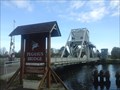
 view gallery view galleryW2.9 km | Pegasus Bridge Site - Bénouville, Normandie, France in Histoires de France (French historical markers) Dans les premières minutes du 6 juin 1944, les troupes de planeurs de la 5e division aéroportée s’emparent du pont qui se trouvait sur ce site au-dessus du canal de Caen. posted by: Don.Morfe location: Normandie, France date approved: 08/01/2022 last visited: 07/30/2022 |
 view gallery view galleryW2.9 km | Major R. J. Howard - Bénouville, Normandie-France in Specific Veteran Memorials The Horsa Glider of Major R. J. Howard, Oxfordshire and Buckinghamshire Light Infantry who commanded the operation to capture the bridge, landed on this spot together with Lieutenant H. D. Brotheridge and 28 soldiers at 0016 hours on 6 June 1944. posted by: Don.Morfe location: Normandie, France date approved: 08/04/2022 last visited: 07/30/2022 |
 view gallery view galleryW2.9 km |  Prise du pont Pegasus Bridge (D-DAY) à Benouville, Normandie, France Prise du pont Pegasus Bridge (D-DAY) à Benouville, Normandie, France
in Battlefields Pegasus Bridge – Opération Deadstick – Bénouville – Jour J. posted by: Team Glandouillage location: Normandie, France date approved: 12/22/2016 last visited: 07/30/2022 |
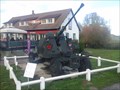 view gallery view galleryW2.9 km |  Bofors 40 mm - Pegasus Bridge (Normandie), France Bofors 40 mm - Pegasus Bridge (Normandie), France
in Static Artillery Displays [FR] Le 40 mm Bofors est un canon antiaérien conçu par l’armurier suédois Bofors au début des années 1930. [EN] The Bofors 40 mm gun is an anti-aircraft/multi-purpose autocannon designed in the 1930s by the Swedish arms manufacturer AB Bofors. posted by: RakeInTheCache location: Normandie, France date approved: 11/17/2016 last visited: 07/30/2022 |
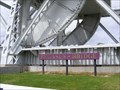
 view gallery view galleryW3.1 km |  Pegasus Bridge - Benouville, France Pegasus Bridge - Benouville, France
in Official Local Tourism Attractions Pegasus Bridge, originally called the Bénouville Bridge after the neighbouring village, is a road crossing over the Caen Canal, between Caen and Ouistreham in Normandy. The original bridge was in built in 1934. posted by: Don.Morfe location: Normandie, France date approved: 07/31/2022 last visited: 07/30/2022 |
 view gallery view galleryW3.1 km |  Pegasus Bridge - Benouville, France Pegasus Bridge - Benouville, France
in Wikipedia Entries Pegasus Bridge, originally called the Bénouville Bridge after the neighbouring village, is a road crossing over the Caen Canal, between Caen and Ouistreham in Normandy. The original bridge was in built in 1934. posted by: Don.Morfe location: Normandie, France date approved: 06/27/2021 last visited: 09/01/2021 |
 view gallery view galleryW3.1 km |  Pegasus Bridge - Benouville, France Pegasus Bridge - Benouville, France
in Bailey Bridges Pegasus Bridge, originally called the Bénouville Bridge after the neighbouring village, is a road crossing over the Caen Canal, between Caen and Ouistreham in Normandy. posted by: Don.Morfe location: Normandie, France date approved: 07/13/2021 last visited: 08/05/2022 |
 view gallery view galleryW3.1 km |  Pegasus Bridge - Benouville, France Pegasus Bridge - Benouville, France
in Satellite Imagery Oddities Pegasus Bridge, originally called the Bénouville Bridge after the neighbouring village, is a road crossing over the Caen Canal, between Caen and Ouistreham in Normandy. The original bridge was in built in 1934. posted by: Don.Morfe location: Normandie, France date approved: 07/30/2022 last visited: 07/30/2022 |
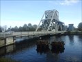 view gallery view galleryW3.1 km |  Pegasus Bridge - Bénouville, France Pegasus Bridge - Bénouville, France
in Moving Bridges [FR] Il s'agit d'un pont basculant du type Scherzer. [EN] Pegasus Bridge and the structure that replaced it in 1994 are examples of a distinct sub type of bascule bridge, the "Scherzer rolling lift bascule bridge" or "rolling bridge". posted by: RakeInTheCache location: Normandie, France date approved: 11/13/2016 last visited: 07/30/2022 |
 view gallery view galleryW3.1 km |  Pegasus Bridge - Bénouville, France Pegasus Bridge - Bénouville, France
in World War II Sites [FR] Pegasus Bridge (pont Pégase) est le nom qu'a reçu après les opérations du 6 juin 1944, pendant la Seconde Guerre mondiale le pont de Bénouville [EN] It was a major objective of the British airborne troops during Operation Deadstick. posted by: RakeInTheCache location: Normandie, France date approved: 11/14/2016 last visited: 07/30/2022 |
 view gallery view galleryW3.1 km |  FIRST - French House Liberated On D-day FIRST - French House Liberated On D-day
in First of its Kind [FR] Le café Gondrée est souvent présenté comme la première maison de France continentale à avoir été libérée. [EN] Café Gondrée, located near the bridge of Pegasus Bridge was the first House liberated from France, in the last hour of June 5, 1944. posted by: RakeInTheCache location: Normandie, France date approved: 11/13/2016 last visited: 07/30/2022 |
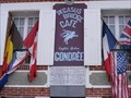 view gallery view galleryW3.1 km | First House Liberated in France - Benouville, Normandie, France in Histoires de France (French historical markers) This was the first house in France to be liberated during the last hour of 5th June 1944 by men of the Oxfordshire & Buckinghamshire Light Infantry in the British 6th Airborne Division. posted by: Don.Morfe location: Normandie, France date approved: 08/01/2022 last visited: 07/30/2022 |
 view gallery view gallery N3.1 km N3.1 km
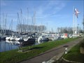
|  Port de Plaisance de Ouistreham - Ouistreham (Normandie), France Port de Plaisance de Ouistreham - Ouistreham (Normandie), France
in Marinas [FR] Le port de plaisance (650 anneaux), est géré par la Chambre de commerce et d'industrie de Caen. [EN] Boating has for long been a common activity in Ouistreham, thanks to the action of the Société des Régates de Caen-Ouistreham. posted by: RakeInTheCache location: Normandie, France date approved: 11/17/2016 last visited: 06/07/2021 |
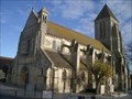 view gallery view galleryNW3.5 km |  Eglise Saint Samson, Ouistreham Eglise Saint Samson, Ouistreham
in French Benchmarks [FR]Borne de nivellement située sur la face sud de l’Eglise Saint Samson, sur le contrefort le plus à l’ouest. [EN]Border of leveling situated on the face south of the Church Saint Samson, on the buttress most in the west. posted by: 7seven location: Normandie, France date approved: 12/15/2011 last visited: 07/22/2019 |
 view gallery view galleryN3.7 km |  Le phare d'Ouistreham / The Ouistreham Lighthouse (Normandy, France) Le phare d'Ouistreham / The Ouistreham Lighthouse (Normandy, France)
in Philatelic Photographs The stamp is devoted to the well known Ouistreham Lighthouse (Le phare d'Ouistreham) in Ouistreham (Calvados, Normandy). posted by: Dorcadion Team location: Normandie, France date approved: 06/09/2009 last visited: 07/15/2020 |
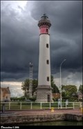 view gallery view galleryN3.7 km |  Le phare d'Ouistreham (Normandy, France) Le phare d'Ouistreham (Normandy, France)
in Monuments Historiques Français Depicted beautiful lighthouse, Le phare d'Ouistreham, is symbol of the Ouistreham's harbour. The present lighthouse, that replaced other means of signs and markings, was built in 1905. posted by: Dorcadion Team location: Normandie, France date approved: 08/14/2014 last visited: 07/15/2020 |
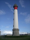 view gallery view galleryN3.7 km | Le phare de Ouistreham in French Benchmarks [FR]Borne de nivellement située à la base du phare, sur la face nord.[EN]Border of leveling situated on the base of the lighthouse, on the north face. posted by: 7seven location: Normandie, France date approved: 12/15/2011 last visited: 07/15/2020 |
 view gallery view gallery NE3.7 km NE3.7 km
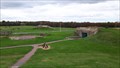
| Musée de la Batterie de Merville in War and Military Museums La Batterie de Merville est une fortification de l'armée de terre allemande sur le flan EST du Débarquement allié le 6 Juin 1944.
The Merville Battery is a fortification of the German Army on the east side of the Allied Landing on June 6, 1944. posted by: Team Glandouillage location: Normandie, France date approved: 12/09/2016 last visited: 11/11/2016 |
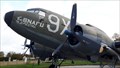 view gallery view galleryNE3.7 km |  Douglas C-47 SNAFU Special - Museum of Batterie Merville, Basse-Normandie, FR Douglas C-47 SNAFU Special - Museum of Batterie Merville, Basse-Normandie, FR
in Static Aircraft Displays Twin-engine Douglas C 47 n ° 43-15-073 called SNAFU Special. posted by: Team Glandouillage location: Normandie, France date approved: 11/16/2016 last visited: 11/11/2016 |
|