 view gallery view gallery SW0 km SW0 km
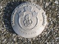
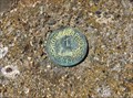
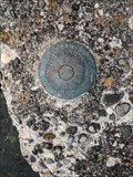
|   Hydrographic marker 8779763 Hydrographic marker 8779763
in Canadian Benchmarks On top of Mt Warburton Pike on Saturna Island posted by:  sole seeker sole seeker location: British Columbia, Canada date approved: 06/08/2008 last visited: 06/07/2016 |
 view gallery view gallery SE0.2 km SE0.2 km
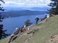
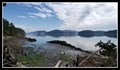
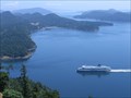
|  Brown Ridge, Saturna Island BC Brown Ridge, Saturna Island BC
in Scenic Hikes One of the best scenic hikes in the Gulf Islands is the Brown Ridge of Mt Warburton Pike on Saturna Island. The views along the ridge over the San Juan and Gulf Islands are spectacular. Most of the ridge trail is in the Gulf Islands National Park. posted by:  arby101ca arby101ca location: British Columbia, Canada date approved: 05/28/2010 last visited: 06/07/2016 |
 view gallery view gallery NW3.4 km NW3.4 km
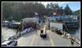
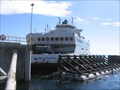
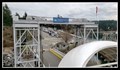
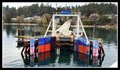
|  Lyall Harbour Ferry Terminal – Saturna, BC Lyall Harbour Ferry Terminal – Saturna, BC
in Ferries and Ferry Landings Of the five Southern Gulf Islands served by the BC Ferries network Saturna Island is the smallest. posted by: Dunbar Loop location: British Columbia, Canada date approved: 03/25/2019 last visited: never |
 view gallery view gallery E9.3 km E9.3 km
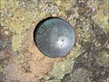
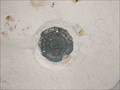
| International Boundary Commission Marker - Saturna Island, British Columbia, Canada in Canadian Benchmarks This International Boundary Commission marker is located on a rock outcrop just south of the old foghorn building at East Point on Saturna Island, British Columbia, Canada. posted by: The A-Team location: British Columbia, Canada date approved: 08/11/2015 last visited: 06/07/2016 |
 view gallery view galleryE9.3 km | 1-1965 - Saturna Island, British Columbia, Canada in Canadian Benchmarks This Hydrographic Service Canada benchmark is located in the top of a 1.5 foot tall concrete pyramid at East Point on Saturna Island, British Columbia, Canada. posted by: The A-Team location: British Columbia, Canada date approved: 08/11/2015 last visited: 06/07/2016 |
 view gallery view galleryNW10 km |  Gulf Islands National Park Reserve - Bennett Bay Unit — Mayne Island, BC Gulf Islands National Park Reserve - Bennett Bay Unit — Mayne Island, BC
in National Parks of the World The Gulf Islands of Canada's West Coast has some of the most spectacular vistas and views. Bennett Bay Unit of the Gulf Island NPR offers the public a great place to relax on a scenic beach. posted by: Dunbar Loop location: British Columbia, Canada date approved: 04/07/2019 last visited: never |
 view gallery view gallerySW10.6 km |  9802 E 1976 - San Juan Co., WA 9802 E 1976 - San Juan Co., WA
in U.S. Benchmarks Benchmark is disk placed in the concrete base of TURN PT LIGHT 1942 (TR2294) posted by: lahontan location: Washington date approved: 07/20/2022 last visited: never |
 view gallery view gallerySW10.8 km | 9802 B 1976 - San Juan, Co., WA in U.S. Benchmarks Benchmark disk in old concrete footing of some historical structure. posted by: lahontan location: Washington date approved: 07/20/2022 last visited: never |
 view gallery view gallerySW10.8 km | 9802 A 1976 - San Juan., WA in U.S. Benchmarks Benchmark in concrete base of historic dock footing/base at Turn Point light station. posted by: lahontan location: Washington date approved: 07/20/2022 last visited: never |
 view gallery view gallery W10.9 km W10.9 km
| Otter Bay Ferry terminal, Pender Island, BC in Ferries and Ferry Landings The BC Ferries terminal for Pender Island is at Otter Bay on North Pender Island in the Southern Gulf Islands in the Salish Sea. posted by: arby101ca location: British Columbia, Canada date approved: 09/14/2010 last visited: 08/23/2018 |
 view gallery view galleryNW12.6 km |  Mayne Island Community Library – Mayne Island, BC Mayne Island Community Library – Mayne Island, BC
in Libraries The Mayne Island Community Library operates as a part of the five branch Southern Gulf Islands Community Libraries network. posted by: Dunbar Loop location: British Columbia, Canada date approved: 03/27/2019 last visited: never |
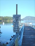 view gallery view galleryNW12.9 km |  7 KM/H - Miners Bay Wharf 7 KM/H - Miners Bay Wharf
in Unusual Speed Limits A 7 km/h speed limit sign at Miners Bay Gov't wharf. posted by: Kiwibirdman location: British Columbia, Canada date approved: 03/03/2011 last visited: never |
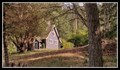 view gallery view galleryNW13 km |  St Mary Magdalene (1897) – Mayne Island, BC St Mary Magdalene (1897) – Mayne Island, BC
in This Old Church Built-in 1897 St Mary Magdalene continues to serve as Mayne Island's only church. posted by: Dunbar Loop location: British Columbia, Canada date approved: 03/27/2019 last visited: never |
 view gallery view galleryNW13.7 km | Village Bay Ferry Terminal – Mayne Island, BC in Ferries and Ferry Landings The Village Bay Terminal is a busy terminal as it both serves people going to and from Mayne Island, but it is also the transfer point between four other terminals in the Gulf Islands, one on Vancouver Island, and one on the Mainland. posted by: Dunbar Loop location: British Columbia, Canada date approved: 04/08/2019 last visited: never |
 view gallery view galleryNW14 km | Gulf Islands National Park Reserve - Georgina Point Unit — Mayne Island, BC in National Parks of the World The Gulf Islands of Canada's West Coast has some of the most spectacular vistas and views. Georgina Point Unit of the Gulf Island NPR offers great views of the entrance to Active Pass. posted by: Dunbar Loop location: British Columbia, Canada date approved: 04/04/2019 last visited: never |
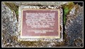 view gallery view galleryNW14.2 km |  Georgina Point Lighthouse — Mayne Island, BC Georgina Point Lighthouse — Mayne Island, BC
in British Columbia Heritage Markers A brief description of the Georgina Point Lighthouse posted by: Dunbar Loop location: British Columbia, Canada date approved: 10/17/2019 last visited: never |
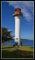
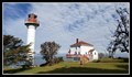 view gallery view galleryNW14.2 km |  Active Pass Lighthouse — Mayne Island, BC Active Pass Lighthouse — Mayne Island, BC
in Western Canadian Heritage Since 1885 there's been a lighthouse at Mayne Island's Georgina Point guiding vessels through Active Pass. Built in 1969 this is the third lighthouse at this location. posted by: Dunbar Loop location: British Columbia, Canada date approved: 11/12/2022 last visited: never |
 view gallery view galleryNW14.2 km |  Active Pass Lighthouse — Mayne Island, BC Active Pass Lighthouse — Mayne Island, BC
in Coastal Lighthouses Since 1885 there's been a lighthouse at Mayne Island's Georgina Point guiding vessels through Active Pass. This is the third lighthouse at this location. posted by: Dunbar Loop location: British Columbia, Canada date approved: 04/06/2019 last visited: never |
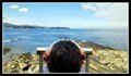 view gallery view galleryNW14.2 km |  Georgina Point Binoculars — Mayne Island, BC Georgina Point Binoculars — Mayne Island, BC
in Coin-Op Binoculars Georgina Point is at the entrance of the very busy maritime route through Active Pass which separates Mayne and Galiano islands. It is used by BC Ferries and small craft vessels travelling from the posted by: Dunbar Loop location: British Columbia, Canada date approved: 03/27/2019 last visited: never |
 view gallery view galleryNW15.4 km | Sturdies Bay Ferry Terminal – Galiano, BC in Ferries and Ferry Landings Galiano Island is a popular destination for people on British Columbia's Lower Mainland and Vancouver Island and the Sturdies Bay Ferry Terminal is where BC Ferries lands the vast majority of visitors. posted by: Dunbar Loop location: British Columbia, Canada date approved: 03/25/2019 last visited: 08/26/2018 |
 view gallery view gallery S15.9 km S15.9 km
|  Sidney-Anacortes Ferry Border Crossing Sidney-Anacortes Ferry Border Crossing
in Border Crossings The Sidney-Anacortes ferry departs to cross the Canada-US border from the Sidney International Terminal at the location waymarked here in Boundary Passage of the Straits of Juan de Fuca. Also see WM8X4E for ferry information. posted by: arby101ca location: British Columbia, Canada date approved: 05/26/2010 last visited: 08/24/2013 |
 view gallery view galleryNW17.2 km |  Mt Galiano Summit, Galiano Island, BC Mt Galiano Summit, Galiano Island, BC
in Mountain Summits The summit viewpoint on Mt Galiano offers spectacular views over the Gulf Islands and Active Pass. posted by: arby101ca location: British Columbia, Canada date approved: 05/02/2010 last visited: never |
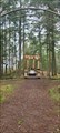 view gallery view galleryS17.7 km |  McMillin Memorial Mausoleum - Roche Harbor, San Juan Island McMillin Memorial Mausoleum - Roche Harbor, San Juan Island
in Mausoleums The McMillinin Mausoleum is the final resting place of businessman John S. McMillin, his wife and children and one of the family's employees. The design of the mausoleum incorporates numerous instances of symbolism, some of it Masonic. posted by: jtcoffee location: Washington date approved: 02/17/2023 last visited: 02/23/2024 |
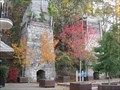 view gallery view galleryS18.5 km |  Lime Kilns at Roche Harbor, San Juan Island, Washington Lime Kilns at Roche Harbor, San Juan Island, Washington
in Ovens and Kilns Old Lime Kilns located at Roche Harbor at the north end of San Juan Island. posted by: Rose Red location: Washington date approved: 11/30/2011 last visited: 02/23/2024 |
 view gallery view gallerySW20 km | CGSN 9045-1979 - North Saanich, BC in Canadian Benchmarks Located at the foot of the Swartz Bay government wharf in North Saanich, BC. posted by: The A-Team location: British Columbia, Canada date approved: 07/23/2013 last visited: never |
|