 view gallery view gallery SE35.6 km SE35.6 km
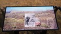
|   Sleeping Buffalo Rock Petroglyphs - Montana Sleeping Buffalo Rock Petroglyphs - Montana
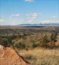
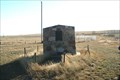
in Pictographs There are two rocks with petroglyphs in a small three-sided shed in a small wayside (along with 2 Montana Historical Markers) on the north side of US Hwy 2 near Nelson State Recreation Area. posted by:  PeterNoG PeterNoG location: Montana date approved: 11/12/2008 last visited: 09/28/2020 |
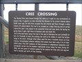 view gallery view gallerySE35.6 km |  Cree Crossing Cree Crossing
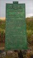
in Montana Historical Markers This Montana Historical Marker along with the "Sleeping Buffalo Rock" marker are in a small wayside on the north side of US Hwy 2 near Nelson State Recreation Area. posted by: PeterNoG location: Montana date approved: 11/12/2008 last visited: 08/02/2015 |
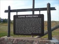 view gallery view gallerySE35.6 km | Sleeping Buffalo Rock in Montana Historical Markers This Montana Historical Marker along with the "Cree Crossing" marker are in a small wayside on the north side of US Hwy 2 near Nelson State Recreation Area. posted by: PeterNoG location: Montana date approved: 11/12/2008 last visited: 08/02/2015 |
 view gallery view gallery NE47.6 km NE47.6 km
|  Ernest Dufault 'Will James' Ernest Dufault 'Will James'
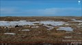
in Saskatchewan Historical Markers This old homestead of Ernest Dufault 'Will James', is located in Grasslands National Park in South Saskatchewan. posted by:  Altima Voyageur Altima Voyageur location: Saskatchewan, Canada date approved: 09/16/2017 last visited: never |
 view gallery view galleryNE47.6 km | Walt Larson in Saskatchewan Historical Markers Located in Grasslands National Park posted by: Altima Voyageur location: Saskatchewan, Canada date approved: 09/16/2017 last visited: never |
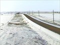 view gallery view gallerySE47.6 km |  Saco Web Camera - Saco, MT Saco Web Camera - Saco, MT
in Web Cameras This is one of 73 (as of February 2017) Road Weather Information System camera sites operated by the Montana Department of Transportation to aid motorists as they make their way across BIG SKY Country. posted by: T0SHEA location: Montana date approved: 02/09/2017 last visited: never |
 view gallery view gallery N50.7 km N50.7 km
| Bison Watering Hole - Val Marie, Saskatchewan, Canada in Web Cameras This Web Camera is in Grasslands National Park to the east of Val marie, Saskatchewan. posted by: Lightnin Bug location: Saskatchewan, Canada date approved: 12/30/2023 last visited: never |
 view gallery view galleryN53.8 km | Arthur L. Lemire/ Val Marie Grain Elevator in Saskatchewan Historical Markers Located in the town of Val Marie, this plaque and grain elevator. posted by: Altima Voyageur location: Saskatchewan, Canada date approved: 09/17/2017 last visited: never |
 view gallery view galleryN53.9 km | The Village of Val Marie in Saskatchewan Historical Markers This plaque is located on the main street in Val Marie. posted by: Altima Voyageur location: Saskatchewan, Canada date approved: 09/16/2017 last visited: never |
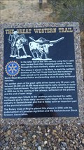 view gallery view galleryN53.9 km | The Great Western Trail in Saskatchewan Historical Markers This monument is located at the old school/gift shop in the town of Val Marie. posted by: Altima Voyageur location: Saskatchewan, Canada date approved: 09/16/2017 last visited: never |
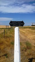 view gallery view galleryN54.4 km | NWMP Trail in Saskatchewan Historical Markers This trail marker is located just North of Val Marie on town edge. posted by: Altima Voyageur location: Saskatchewan, Canada date approved: 09/16/2017 last visited: never |
 view gallery view gallery SW54.4 km SW54.4 km
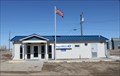
|  Dodson, Montana 59524 Dodson, Montana 59524
in U.S. Post Offices Newer PO in a small town posted by: ZenPanda location: Montana date approved: 11/05/2014 last visited: 10/03/2014 |
 view gallery view galleryNE71 km | Mankota Coal Mines in Saskatchewan Historical Markers South of the town of Mankota posted by: Altima Voyageur location: Saskatchewan, Canada date approved: 09/16/2017 last visited: never |
 view gallery view gallery W80 km W80 km
|  Ft. Belknap Reservation, Gros Ventre & Assiniboine - Montana, USA Ft. Belknap Reservation, Gros Ventre & Assiniboine - Montana, USA
in Nations Within Nations Gros Ventre & Assiniboine - Nakoda posted by: CerealBoxMonsters location: Montana date approved: 07/30/2009 last visited: never |
 view gallery view gallery NW88.7 km NW88.7 km
| Fort Walsh- Wood Mountain Trail (South of Shaunavon) in Saskatchewan Historical Markers Located south of Shaunavon, Sask. posted by: Altima Voyageur location: Saskatchewan, Canada date approved: 09/16/2017 last visited: never |
 view gallery view gallerySW97.8 km | Malta North Web Camera - Malta, MT in Web Cameras This is one of 73 (as of January 2017) Road Weather Information System camera sites operated by the Montana Department of Transportation to aid motorists as they make their way across BIG SKY Country. posted by: T0SHEA location: Montana date approved: 02/07/2017 last visited: never |
 view gallery view gallerySW97.8 km | Malta Roadway Web Camera - Malta, MT in Web Cameras This is one of 73 (as of January 2017) Road Weather Information System camera sites operated by the Montana Department of Transportation to aid motorists as they make their way across BIG SKY Country. posted by: T0SHEA location: Montana date approved: 02/07/2017 last visited: never |
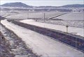 view gallery view gallerySW97.8 km | Malta South Web Camera - Malta, MT in Web Cameras This is one of 73 (as of January 2017) Road Weather Information System camera sites operated by the Montana Department of Transportation to aid motorists as they make their way across BIG SKY Country. posted by: T0SHEA location: Montana date approved: 02/07/2017 last visited: never |
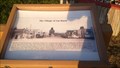
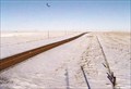
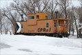 view gallery view galleryNE99.9 km |  CP Rail Caboose 434405 - McCord, SK CP Rail Caboose 434405 - McCord, SK
in Train Cabooses Caboose parked on museum grounds in McCord, SK
posted by: kjohn73 location: Saskatchewan, Canada date approved: 03/30/2009 last visited: never |
 view gallery view galleryNE100.4 km | Belsher Family in Saskatchewan Historical Markers Just located on access road to McCord, Saskatchewan. posted by: Altima Voyageur location: Saskatchewan, Canada date approved: 09/16/2017 last visited: never |
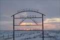 view gallery view galleryNE103 km | Montague School District # 4031 in Saskatchewan Historical Markers Nice marker acknowledging the Montague School. posted by: kjohn73 location: Saskatchewan, Canada date approved: 03/08/2009 last visited: never |
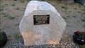
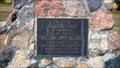
 view gallery view galleryNE106.9 km |  Glentworth Branch #342 Cenotaph Glentworth Branch #342 Cenotaph
in Canadian Legion Memorials Cairns and Cenotaphs Memorial for those who fell in wars. posted by: kjohn73 location: Saskatchewan, Canada date approved: 12/04/2008 last visited: never |
 view gallery view galleryN108 km | Hamlet of Crichton 1913-1982 in Saskatchewan Historical Markers Located up on the South side of the hwy up a few meters from the road. No noticeable historical sign post to advertise this rock-cairn. posted by: Altima Voyageur location: Saskatchewan, Canada date approved: 06/18/2013 last visited: never |
 view gallery view galleryN109.1 km | "Mo" The Ponteix Plesiosaur (Elasmosaur) in Saskatchewan Historical Markers Located outside of the community of Ponteix, SK, on the junction of Hwy. 13 and Hwy. 628. posted by: Altima Voyageur location: Saskatchewan, Canada date approved: 06/26/2013 last visited: never |
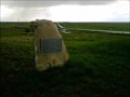
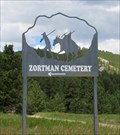 view gallery view gallerySW109.4 km |  Zortman Cemetery - Zortman, Montana Zortman Cemetery - Zortman, Montana
in Worldwide Cemeteries If you want an adventure, Zortman Cemetery is the place to visit. Must caution: do not attempt a visit during the rainy or winter seasons. posted by: T0SHEA location: Montana date approved: 01/05/2018 last visited: never |
|