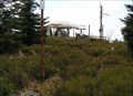
 view gallery view gallery N2.6 km N2.6 km
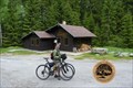
|   Alpenblick, Ulrichsberg , Austria Alpenblick, Ulrichsberg , Austria
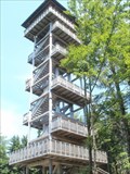
in Look-Out Towers Wooden look-out tower with a view of the Upper Austria. posted by:  Arne1 Arne1 location: Oberösterreich, Austria date approved: 07/17/2013 last visited: never |
 view gallery view gallery SE4 km SE4 km
|  Marktplatz in Aigen im Mühlkreis, Austria Marktplatz in Aigen im Mühlkreis, Austria
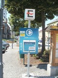
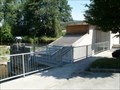
in Electric Car Charging Stations [DE] Ladestation auf dem Marktplatz in Aigen, OO
[EN] Electric charging station on Square in Aigen, Upper Austria posted by: Arne1 location: Oberösterreich, Austria date approved: 07/16/2013 last visited: never |
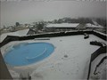 view gallery view gallerySE4.2 km |  Live Cam Hotel Almesberger - Oberösterreich / Austria Live Cam Hotel Almesberger - Oberösterreich / Austria
in Web Cameras Live Cam shows the swimming pool of the hotel posted by: Iris & Harry location: Oberösterreich, Austria date approved: 01/31/2017 last visited: never |
 view gallery view gallery NE4.3 km NE4.3 km
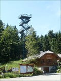
| Moldaublick, Ulrichsberg , Austria in Look-Out Towers Metal look-out tower with a view of the Lipno Lake and surroundings on Czech territory. posted by: Arne1 location: Oberösterreich, Austria date approved: 07/17/2013 last visited: never |
 view gallery view gallerySE4.7 km |  Stift Schlaegel - Schlaegl, OO, Austria Stift Schlaegel - Schlaegl, OO, Austria
in Hydroelectric Power Stations [EN]Small hydro power plant with interesting combination of Kaplan turbines and screw.
[DE]Kleinwasserkraftwerk mit interessante Kombination von Kaplan Turbinen und Schnecke. posted by: Arne1 location: Oberösterreich, Austria date approved: 07/16/2013 last visited: never |
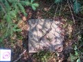
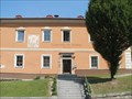 view gallery view gallerySE4.7 km |  Gemeindeamt Schlägl, Austria Gemeindeamt Schlägl, Austria
in Sundials Sundial on the wall of Authority in Schlägl near the abbey in Upper Austria. posted by: Arne1 location: Niederösterreich, Austria date approved: 07/16/2013 last visited: never |
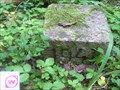
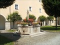 view gallery view gallerySE4.8 km |  Monastery Schlägl, Austria Monastery Schlägl, Austria
in Fountains Fountain with fish in the Upper Austria monastery Schlägl posted by: Arne1 location: Oberösterreich, Austria date approved: 07/15/2013 last visited: never |
 view gallery view galleryN7.1 km |  Kríž na vrcholu hory Hochficht/The cross on the top mountain Hochficht Kríž na vrcholu hory Hochficht/The cross on the top mountain Hochficht
in Christian Crosses CZ: Kríž na vrcholu hory Hochficht
EN: The cross on the top mountain Hochficht posted by:  Waupe Waupe location: Oberösterreich, Austria date approved: 10/07/2010 last visited: 08/26/2014 |
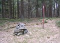
 view gallery view gallery E7.1 km E7.1 km
|  TB 4025-4 Kozi stran TB 4025-4 Kozi stran
in Czech Geodetic Points Trigonometrický bod asi 350m od státní hranice s AUT posted by: pavlikVB location: Jihočeský kraj, Czechia date approved: 10/03/2010 last visited: never |
 view gallery view galleryN7.1 km | TB 4024-22 Smrcina in Czech Geodetic Points Trigonometrický bod na hore Smrcina posted by: pavlikVB location: Jihočeský kraj, Czechia date approved: 05/06/2009 last visited: 07/05/2013 |
 view gallery view galleryE8.7 km | TB 4025-6 Kyselovsky les in Czech Geodetic Points Trigonometrický bod u Lipenské nádrže posted by: pavlikVB location: Jihočeský kraj, Czechia date approved: 07/17/2011 last visited: 07/20/2011 |
 view gallery view galleryN9.7 km | TB 3904-6 Studnicna in Czech Geodetic Points Trigonometrický bod na hore Studnicná posted by: pavlikVB location: Jihočeský kraj, Czechia date approved: 05/06/2009 last visited: 07/05/2013 |
 view gallery view galleryN10.8 km | TB 4024-15 Na skalce in Czech Geodetic Points Trigonometrický bod u Lipenské nádrže posted by: pavlikVB location: Jihočeský kraj, Czechia date approved: 07/17/2011 last visited: never |
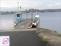 view gallery view galleryE10.9 km |  Dolni Vltavice - Kyselov Ferry, CZE Dolni Vltavice - Kyselov Ferry, CZE
in Ferries and Ferry Landings Nejdelší prívoz v Ceské Republice / The longest ferry in the Czech Republic posted by: pavlikVB location: Jihočeský kraj, Czechia date approved: 10/11/2010 last visited: 08/08/2017 |
 view gallery view galleryE10.9 km |  Anchor, Dolni Vltavice, Lipno, CZE Anchor, Dolni Vltavice, Lipno, CZE
in Anchors Kotva na brehu Lipenské vodní nádrže / Anchor on the shore of the Lipno dam posted by: pavlikVB location: Jihočeský kraj, Czechia date approved: 10/03/2010 last visited: 08/08/2017 |
 view gallery view galleryE11.1 km | TB 4020-6 Josefinus, Cerná v Pošumaví (CK) in Czech Geodetic Points Trigonomerický bod 4020-6.0 je na vrchu táhlé kupy v severovýchodním okraji osady Dolní Vltavice. posted by: torfik location: Jihočeský kraj, Czechia date approved: 09/16/2010 last visited: 08/08/2017 |
 view gallery view galleryNE11.3 km | TB 4024-17 Pramske dvory in Czech Geodetic Points Trigonometrický bod v CHKO Šumava posted by: pavlikVB location: Jihočeský kraj, Czechia date approved: 10/19/2015 last visited: never |
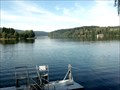 view gallery view galleryE11.3 km |  LARGEST -- water reservoir in Czech Rep., Lipno, Czech Republic LARGEST -- water reservoir in Czech Rep., Lipno, Czech Republic
in Superlatives Lake Lipno as South Bohemian Sea posted by: ToRo61 location: Jihočeský kraj, Czechia date approved: 10/08/2011 last visited: 06/12/2018 |
 view gallery view galleryN11.6 km |  No.1316, Rijište - Sumava, CZ No.1316, Rijište - Sumava, CZ
in Tourist Stamps Photos CS: Malá šumavská slat / EN: Small moor of the Bohemian Forest posted by: pavlikVB location: Jihočeský kraj, Czechia date approved: 05/31/2012 last visited: never |
 view gallery view gallery NW12.2 km NW12.2 km
|  Plechý - Šumava (Bohemian Forest / Böhmerwald) Mts. (Czech Republic) Plechý - Šumava (Bohemian Forest / Böhmerwald) Mts. (Czech Republic)
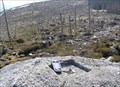
in Mountain Summits Plechý mountain (1 378 m) is the highest mountain of the Czech part of the Šumava mountains (Bohemian Forest). It lies 14 km west of the village Horní Planá and about 8 km south-west of the small village Nová Pec on the Czech-Austrian border. posted by: Dorcadion Team location: Jihočeský kraj, Czechia date approved: 05/27/2009 last visited: 08/21/2020 |
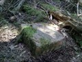
 view gallery view galleryNW12.2 km | TB 3904-4 Plechy in Czech Geodetic Points Trigonometrický bod na hore Plechý posted by: pavlikVB location: Jihočeský kraj, Czechia date approved: 05/06/2009 last visited: 08/21/2020 |
 view gallery view gallerySE12.4 km | TB 5321-3 U Horní Ureše in Czech Geodetic Points Trigonometrický bod na státní hranici s AUT posted by: pavlikVB location: Jihočeský kraj, Czechia date approved: 06/05/2020 last visited: never |
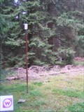
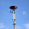 view gallery view galleryNE12.4 km |  Outdoor siren in Horní Planá (Czech Republic) Outdoor siren in Horní Planá (Czech Republic)
in Outdoor Warning Sirens Outdoor warning siren in Horní Planá (Ceský Krumlov District, Czech Republic) posted by: torfik location: Jihočeský kraj, Czechia date approved: 09/15/2010 last visited: 07/24/2016 |
 view gallery view galleryNE12.6 km | No.504, Horní Planá - Sumava, CZ in Tourist Stamps Photos CS: Horní Planá je mesto ležící na Šumave na levém brehu vodní nádrže Lipno. Má asi 2300 obyvatel. Je rodištem spisovatele Adalberta Stiftera. / EN: Horní Planá is a town in Ceský Krumlov District, CZ. It has a population of 2300. It is the posted by: pavlikVB location: Jihočeský kraj, Czechia date approved: 06/02/2012 last visited: 07/11/2016 |
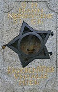 view gallery view galleryNE12.7 km |  1724 - Statue of St. John of Nepomuk - Horní Planná, Czech Republic 1724 - Statue of St. John of Nepomuk - Horní Planná, Czech Republic
in Chronograms A chronogram on the pedestal of the statue of St. John of Nepomuk posted by: ToRo61 location: Jihočeský kraj, Czechia date approved: 06/30/2023 last visited: never |
|