 view gallery view gallery NE11.6 km NE11.6 km
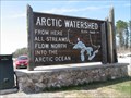
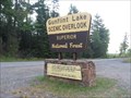
|   Arctic Watershed, Atikokan, ON Arctic Watershed, Atikokan, ON
in Elevation Signs This Arctic Watershed sign lists the elevation as 1660 feet above sea level. posted by:  wildernessmama wildernessmama location: Ontario, Canada date approved: 05/28/2013 last visited: never |
 view gallery view gallery NW20.4 km NW20.4 km
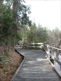
|  Barrier-Free Boardwalk - French Lake, ON Barrier-Free Boardwalk - French Lake, ON
in Non-Coastal Boardwalks This 1 km (.6 mile) boardwalk runs from the Dawson Trail Visitor Center to the beach on French Lake. posted by: wildernessmama location: Ontario, Canada date approved: 06/02/2013 last visited: never |
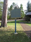 view gallery view galleryNW20.4 km |  French Portage Plaque – French Lake, ON French Portage Plaque – French Lake, ON
in Ontario Provincial Plaques This Ontario Provincial Plaque is found in the Dawson Trail Campground at French Lake. posted by: wildernessmama location: Ontario, Canada date approved: 05/30/2013 last visited: never |
 view gallery view gallery S46.7 km S46.7 km
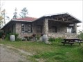
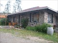
|  Chik Wauk Lodge - Grand Marais, MN Chik Wauk Lodge - Grand Marais, MN
in U.S. National Register of Historic Places The rock lodge was built in 1934 as part of the Chik Wauk Fishing Resort but was sold to the Forest Service when the Boundary Waters Canoe Area Wilderness Act went into effect in 1978. posted by: wildernessmama location: Minnesota date approved: 08/08/2014 last visited: never |
 view gallery view galleryS46.7 km |  Chik Wauk Museum – Grand Marais, MN Chik Wauk Museum – Grand Marais, MN
in History Museums The Chik Wauk Museum officially opened to the public in July 2010, to share with visitors the rich history of the Gunflint area. posted by: wildernessmama location: Minnesota date approved: 10/11/2011 last visited: never |
 view gallery view galleryS46.7 km |  Chik Wauk Museum and Nature Center – Grand Marais, MN Chik Wauk Museum and Nature Center – Grand Marais, MN
in Nature Centers The Chik Wauk Museum and Nature Center officially opened to the public in July 2010. posted by: wildernessmama location: Minnesota date approved: 10/11/2011 last visited: never |
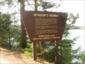 view gallery view galleryS47.8 km |  Voyageur Highway – Grand Marais, MN Voyageur Highway – Grand Marais, MN
in Signs of History This sign is located at the end of the Gunflint Trail and tells the history of this area during the fur trading era. posted by: wildernessmama location: Minnesota date approved: 10/10/2011 last visited: never |
 view gallery view galleryS49.2 km |  Russell Blankenburg – rural Grand Marais Russell Blankenburg – rural Grand Marais
in Minnesota Historical Markers The Russell Blankenburg historical marker is easily found at the Seagull Lake landing near the end of the Gunflint Trail. posted by: wildernessmama location: Minnesota date approved: 06/11/2022 last visited: never |
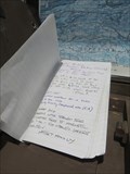 view gallery view galleryS55.7 km |  Border Trail Log Book – rural Grand Marais, MN Border Trail Log Book – rural Grand Marais, MN
in Trail Registers This log book for the Border Trail hikers is located in a drawer at the sign board at the trailhead parking lot. posted by: wildernessmama location: Minnesota date approved: 07/13/2016 last visited: never |
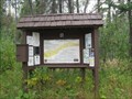 view gallery view galleryS55.8 km | Kekekabic Trail – Grand Marais, MN in Long Distance Hiking Trails These coords take you to the eastern trailhead for the 38 mile long Kekekabic Trail located 47 miles from Grand Marais up the Gunflint Trail. posted by: wildernessmama location: Minnesota date approved: 10/13/2011 last visited: never |
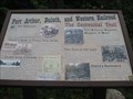 view gallery view galleryS55.8 km | Port Arthur, Duluth, and Western RR & Centennial Trail sign – Grand Marais, MN in Signs of History This sign stands at the trailhead to the Centennial Trail and in the same area where the old mining railroad once ran. posted by: wildernessmama location: Minnesota date approved: 10/10/2011 last visited: never |
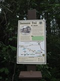 view gallery view galleryS55.8 km |  Centennial Trail – Grand Marais, MN Centennial Trail – Grand Marais, MN
in Self Guided Walks and Trails The Centennial Trail was developed in 2009 after this overgrown historical railroad route was uncovered by a windstorm and a forest fire. posted by: wildernessmama location: Minnesota date approved: 10/12/2011 last visited: never |
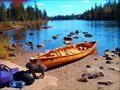 view gallery view galleryS57.5 km |  Brant Lake Loop (Boundary Waters Canoe Area) – Grand Marais, MN Brant Lake Loop (Boundary Waters Canoe Area) – Grand Marais, MN
in Canoe/Kayak Trips The Round Lake landing is the ticket to a few days of canoeing fun in the wilderness. posted by: wildernessmama location: Minnesota date approved: 11/07/2011 last visited: never |
 view gallery view gallery W57.5 km W57.5 km
|  Atikokan Main Post Office P0T 1C0, Atikokan, ON Atikokan Main Post Office P0T 1C0, Atikokan, ON
in Canada Post Offices This post office is located next door to the Atitkokan Centennial Museum. posted by: wildernessmama location: Ontario, Canada date approved: 06/01/2013 last visited: never |
 view gallery view galleryS57.5 km | Gunflint Overlook – Grand Marais, MN in Signs of History This sign is located at the Gunflint Lake Overlook and tells a little about the Voyageur Highway of the 17th Century. posted by: wildernessmama location: Minnesota date approved: 10/10/2011 last visited: never |
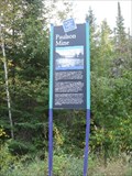 view gallery view galleryS57.5 km | Paulson Mine – Grand Marais, MN in Signs of History Located at the Gunflint Overlook, this sign tells about the Paulson Mine that was just up a nearby trail. posted by: wildernessmama location: Minnesota date approved: 10/10/2011 last visited: never |
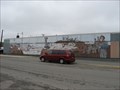 view gallery view galleryW57.6 km |  Lake Movers – Atikokan, ON Lake Movers – Atikokan, ON
in Murals Lake Movers by Heather Schmutzer was done in 1992 to portray a part of the mining history. posted by: wildernessmama location: Ontario, Canada date approved: 06/28/2013 last visited: never |
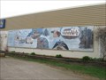
 view gallery view galleryW57.6 km | The Lectra Haul – Atikokan, ON in Murals The Lectra Haul was done by Heather Schmutzer in 1991 and depicts a scene from early mining days in Atikokan. posted by: wildernessmama location: Ontario, Canada date approved: 06/28/2013 last visited: never |
 view gallery view galleryW57.6 km | Atikokan – Atikokan, ON in Murals Atikokan is a collection of scenes from this early days of this community. posted by: wildernessmama location: Ontario, Canada date approved: 06/28/2013 last visited: 08/13/2013 |
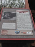 view gallery view galleryW57.6 km | Atikokan Mine Marker and Cart – Atikokan, ON in Signs of History Mining has always been an important part of Atikokan’s history, so it is fitting to have this mine cart and historical marker here in this small park in the middle of town. posted by: wildernessmama location: Ontario, Canada date approved: 06/05/2013 last visited: 08/13/2013 |
 view gallery view galleryNE57.6 km |  Inwood Park--------camping and fun Inwood Park--------camping and fun
in Campgrounds A park I visit.
camping/Rv park,,play ground ,,beach ,,,dock,,brook trout lake ,100'+ lots
with bbq stands..$12/night.......pic of the sign or you in the park.
posted by: mmgg1970 location: Ontario, Canada date approved: 08/19/2009 last visited: 08/05/2011 |
 view gallery view galleryW57.6 km | The Cutting Edge - Atikokan, ON in Murals This historical mural was created by the students of a local art teacher, who researched the background and illustrated the events on this wall in downtown Atikokan. posted by: wildernessmama location: Ontario, Canada date approved: 06/28/2013 last visited: never |
 view gallery view galleryW57.8 km | Art School Collection – Atikokan, ON in Murals These brightly colored murals are located on the exterior walls of the Atikokan Art School. posted by: wildernessmama location: Ontario, Canada date approved: 06/28/2013 last visited: never |
 view gallery view gallery SE63.2 km SE63.2 km
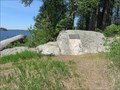
| Laurentian Divide – Grand Marais, MN in Signs of History This sign is located near the Laurentian Divide on the historic Gunflint Trail and tells about the water flowage of the Divide. posted by: wildernessmama location: Minnesota date approved: 10/10/2011 last visited: 07/10/2012 |
 view gallery view gallerySE63.2 km |  Laurentian Divide – Grand Marais, MN Laurentian Divide – Grand Marais, MN
in Watershed Markers and Monuments This sign is located near the Laurentian Divide on the historic Gunflint Trail and tells about the water flowage of the Divide. posted by: wildernessmama location: Minnesota date approved: 12/22/2017 last visited: never |
|