 view gallery view gallery SW4 km SW4 km
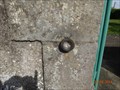
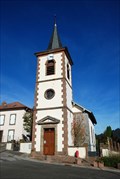
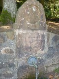
|   eglise de Hablainville eglise de Hablainville
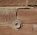
in French Benchmarks a 40 cm du sol derriere l'eglise coté rue posted by:  geotrou geotrou location: Grand-Est, France date approved: 09/29/2014 last visited: never |
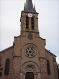
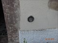 view gallery view gallerySW4.2 km | la chapelle de Hablainville in French Benchmarks a 100cm du sol a droite de l'entrée de la chapelle posted by: geotrou location: Grand-Est, France date approved: 09/30/2014 last visited: never |
 view gallery view gallery E9.2 km E9.2 km
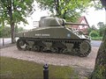
|  M4 Sherman Medium Tank named 'Mort-Homme', Badonviller, France. M4 Sherman Medium Tank named 'Mort-Homme', Badonviller, France.
in Military Ground Equipment Displays A tank placed to commemorate the liberation of Badonviller from the Germans by the French General Leclerc in 1944, during World War II. posted by: Ourspolaire&Gemeloj location: Grand-Est, France date approved: 06/12/2012 last visited: 06/25/2013 |
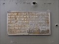 view gallery view galleryE9.2 km |  Badonviller : Mémorial char de la libération, Mort-Homme de la 2e DB du général Leclerc Badonviller : Mémorial char de la libération, Mort-Homme de la 2e DB du général Leclerc
in World War II Memorials / Monuments During the WW II, 1944, the liberation of Badonviller of the German by the French General Leclerc! posted by: Ourspolaire&Gemeloj location: Grand-Est, France date approved: 06/09/2012 last visited: 06/25/2013 |
 view gallery view gallery SE9.3 km SE9.3 km
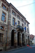
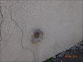
| Mairie - Badonviller, France in French Benchmarks Repère géodésique placé sur la façade de la mairie de Badonviller, en Meurthe et Moselle. posted by: Chris777 location: Grand-Est, France date approved: 10/28/2008 last visited: never |
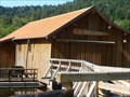 view gallery view gallerySE9.7 km |  Scierie La Hallière- Celle-sur-Plaine-Lorraine,France Scierie La Hallière- Celle-sur-Plaine-Lorraine,France
in Working Water Wheels The sawmill is the Hallière a mill in the village of Celles-sur-Plaine in the Vosges.La Scierie de la Hallière est une scierie située dans la commune de Celles-sur-Plaine dans les Vosges. posted by: gemeloj location: Grand-Est, France date approved: 10/07/2014 last visited: 10/08/2014 |
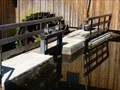 view gallery view gallerySE9.7 km |  La vanne de La Hallière-Celle-sur-Plaine-Lorraine,France La vanne de La Hallière-Celle-sur-Plaine-Lorraine,France
in Historic Hand Operated Sluice Gates An important sluice gate for the sawmill! Une vanne importante pour la scierie! posted by: gemeloj location: Grand-Est, France date approved: 10/11/2014 last visited: 10/11/2014 |
 view gallery view gallery S10.3 km S10.3 km
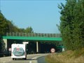
|  N59 traverse de gibier- Baccarat-Grand-Est,France N59 traverse de gibier- Baccarat-Grand-Est,France
in Man-made Animal Bridges and Crossings Un pont pour la sécurité du gibier. A bridge for the safety of wild animals posted by: gemeloj location: Grand-Est, France date approved: 10/26/2018 last visited: 10/30/2018 |
 view gallery view gallerySW10.5 km | eglise de Badménil in French Benchmarks a droite de la façade de l'eglise a 40 cm de hauteur posted by: geotrou location: Grand-Est, France date approved: 09/30/2014 last visited: never |
 view gallery view gallerySE10.5 km | BERTRICHAMPS II in French Benchmarks La deuxième borne de la commune de Bertrichamps (54) posted by: Pat5488 location: Grand-Est, France date approved: 09/22/2008 last visited: 03/22/2015 |
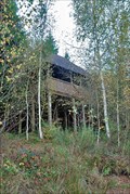 view gallery view gallerySE11.4 km |  Observatoire du lac du Vieux pré - Pierre Percée, France Observatoire du lac du Vieux pré - Pierre Percée, France
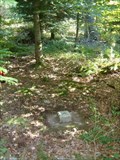
in Birdwatching Locations [FR] Lieu d'observation des oiseaux dans une zone protégée du lac du Vieux Pré.
[ENG] Birdwatching location in a protected area of Vieux Pré lake. posted by: Chris777 location: Grand-Est, France date approved: 10/28/2008 last visited: 04/14/2007 |
 view gallery view gallerySW12.2 km | eglise Fontenoy la joute in French Benchmarks a 40 cm du sol sur le mur de la terrasse de l'eglise posted by: geotrou location: Grand-Est, France date approved: 09/30/2014 last visited: never |
 view gallery view gallerySE13.4 km | Eglise - Pierre Percée, France in French Benchmarks Repère géodésique placé sur l'église du village de Pierre Percée. posted by: Chris777 location: Grand-Est, France date approved: 10/28/2008 last visited: 04/14/2007 |
 view gallery view galleryS13.5 km | Eglise de Thiaville sur Meurthe (54) in French Benchmarks Repère de nivellement cylindrique sur le soubassement en grès du mur de façade de l'église. A droite de la porte. posted by: Pat5488 location: Grand-Est, France date approved: 11/02/2008 last visited: 09/26/2010 |
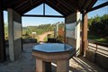 view gallery view gallerySE13.5 km |  Belvédère du Lac du Vieux Pré - Pierre Percée, France Belvédère du Lac du Vieux Pré - Pierre Percée, France
in Orientation Tables [FR] Table d'orientation près du barrage du lac du Vieux Pré, aussi appelé lac de Pierre Percée.
[ENG] Orientation table nearby the Vieux Pré lake, also known as Pierre Percée lake. posted by: Chris777 location: Grand-Est, France date approved: 10/29/2008 last visited: 09/26/2010 |
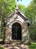 view gallery view galleryE14.2 km |  Chapelle de la Chapelotte-Lorraine,France Chapelle de la Chapelotte-Lorraine,France
in Waychapels Une chapelle dans la fôret! A chapel in the forest! posted by: gemeloj location: Grand-Est, France date approved: 11/23/2014 last visited: never |
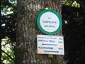
 view gallery view galleryE14.2 km | Un repère dans la fôret-col de la Chapelotte-Lorraine,France in French Benchmarks Un repère sur une chapelle historique! posted by: gemeloj location: Grand-Est, France date approved: 11/24/2014 last visited: never |
 view gallery view gallerySE14.2 km |  Col de la Chapelotte- Grand-Est-France Col de la Chapelotte- Grand-Est-France
in Named Mountain Gaps Un petit col dans le Massif des Vosges. A little gap in Vosges Mountains posted by: gemeloj location: Grand-Est, France date approved: 08/24/2018 last visited: 10/30/2018 |
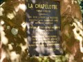 view gallery view gallerySE14.2 km |  Site de combats de 14/18-Col de la Chapelotte-Lorraine,France Site de combats de 14/18-Col de la Chapelotte-Lorraine,France
in World War I Memorials and Monuments Souvenirs de violents combats! Memories of fierce fighting posted by: gemeloj location: Grand-Est, France date approved: 11/27/2014 last visited: never |
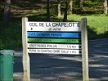
 view gallery view gallerySE14.2 km |  La Chapelotte alt: 447m-Lorraine,France La Chapelotte alt: 447m-Lorraine,France
in Elevation Signs Un col dans les Vosges! A summit in Vosges! posted by: gemeloj location: Grand-Est, France date approved: 11/24/2014 last visited: never |
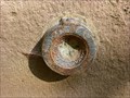
 view gallery view gallerySE14.2 km |  Une belle fontaine gravée- Col de la Chapelotte-Lorraine,France Une belle fontaine gravée- Col de la Chapelotte-Lorraine,France
in Fountains A fountain in a historic site! Une fontaine dans un endroit historique! posted by: gemeloj location: Grand-Est, France date approved: 11/20/2014 last visited: never |
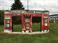 view gallery view galleryS14.6 km |  Bienvenue à Raon l'Etape - France Bienvenue à Raon l'Etape - France
in Welcome Signs A la sortie de la voie express, un rond-point avec une décoration caractéristique de l'art pictural de la région des Vosges.
At the exit of the expressway, a welcome roundabout with a decoration characteristic of the pictorial art of the Vosges. posted by: Alfouine location: Grand-Est, France date approved: 05/08/2019 last visited: never |
 view gallery view galleryS14.6 km |  Bienvenue à Raon l'Etape - France Bienvenue à Raon l'Etape - France
in Pictorial Village Signs A la sortie de la voie express, un rond-point avec une décoration caractéristique de l'art pictural de la région des Vosges.
At the exit of the expressway, a welcome roundabout with a decoration characteristic of the pictorial art of the Vosges. posted by: Alfouine location: Grand-Est, France date approved: 05/08/2019 last visited: never |
 view gallery view galleryS14.6 km |  Bienvenue à Raon l'Etape - France Bienvenue à Raon l'Etape - France
in Artistic Welcome Signs A la sortie de la voie express, un rond-point avec une décoration caractéristique de l'art pictural de la région des Vosges.
At the exit of the expressway, a welcome roundabout with a decoration characteristic of the pictorial art of the Vosges. posted by: Alfouine location: Grand-Est, France date approved: 05/12/2019 last visited: never |
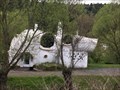 view gallery view galleryS14.8 km |  Museumotel - Raon l'Etape - France Museumotel - Raon l'Etape - France
in Odd-Shaped Buildings Le Museumotel l'Utopie est un motel maison bulle musée sur une île fluviale à Raon-l'Étape dans les Vosges conçu par l'architecte Pascal Haüsermann en 1967. posted by: Alfouine location: Grand-Est, France date approved: 05/19/2019 last visited: never |
|