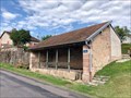
 view gallery view gallery N4.3 km N4.3 km
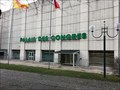
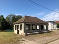
|   Palais des congrès - Vittel - France Palais des congrès - Vittel - France
in Convention Centers Découvrez le Palais des Congrès de Vittel dans la catégorie Centres de conférence, Salles de réunion.
Discover the Palais des Congrès de Vittel in the category Conference Centers, Meeting Rooms. posted by:  Alfouine Alfouine location: Grand-Est, France date approved: 01/24/2018 last visited: never |
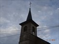
 view gallery view gallery NW4.7 km NW4.7 km
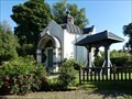
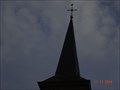
|  La chapelle orthodoxe du parc thermal - Contrexéville, France La chapelle orthodoxe du parc thermal - Contrexéville, France
in Orthodox Churches [EN]
The chapel is located in the thermal park.
[FR]
La chapelle est située dans le parc thermal. posted by: esslpt02100 location: Grand-Est, France date approved: 08/05/2021 last visited: never |
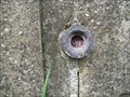
 view gallery view gallery S4.8 km S4.8 km
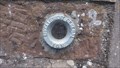
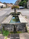
|  viviers le gras viviers le gras
in French Benchmarks a 50 cm du sol contre une maison a coté d'une fontaine posted by: geotrou location: Grand-Est, France date approved: 08/25/2014 last visited: never |
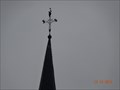
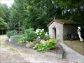 view gallery view galleryNW5 km |  Chapelle Sainte-Anne, Vittel, Lorraine-France Chapelle Sainte-Anne, Vittel, Lorraine-France
in Waychapels Une très vieille chapeele en pleine fôret.
A very old chapel in the forest posted by: gemeloj location: Grand-Est, France date approved: 01/13/2017 last visited: never |
 view gallery view gallery E6.3 km E6.3 km
|  Col du Poirier-Vosges,Lorraine-France Col du Poirier-Vosges,Lorraine-France
in Orientation Tables Une table d'orientation dans la nature. One orientation table in the nature posted by: gemeloj location: Grand-Est, France date approved: 05/14/2017 last visited: never |
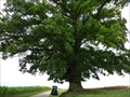 view gallery view galleryE14.2 km |  Le chêne séculaire-Bainville-aux-Saules- Lorraine,France Le chêne séculaire-Bainville-aux-Saules- Lorraine,France
in Exceptional Trees Le grand chêne pédonculé posted by: gemeloj location: Grand-Est, France date approved: 09/24/2016 last visited: never |
 view gallery view gallery NE18.3 km NE18.3 km
| Benchmarck Géodésique Eglise de Mattaincourt in French Benchmarks Point A clocher fleuron supérieur: centre posted by: geotrou location: Grand-Est, France date approved: 12/14/2014 last visited: never |
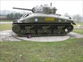
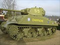 view gallery view galleryE19 km |  Sherman "Champagne" Ville sur illon Sherman "Champagne" Ville sur illon
in Military Ground Equipment Displays commemoratio de la bataille de Dompaire posted by: geotrou location: Grand-Est, France date approved: 06/26/2013 last visited: 05/19/2013 |
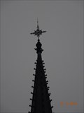
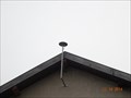 view gallery view galleryNE19 km | Station RGP de Mirecourt in French Benchmarks antenne recetption sommet façade batiment INRA posted by: geotrou location: Grand-Est, France date approved: 12/19/2014 last visited: never |
 view gallery view galleryE21.4 km | Benchmarck Géodésique Dompaire in French Benchmarks Point A : clocher centre boule posted by: geotrou location: Grand-Est, France date approved: 11/11/2014 last visited: never |
 view gallery view galleryE22.5 km | Sherman "Corse" Dompaire in Military Ground Equipment Displays Memorial de la bataille de Dompaire 1944 posted by: geotrou location: Grand-Est, France date approved: 06/26/2013 last visited: 05/19/2013 |
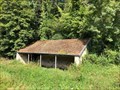
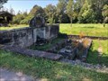
 view gallery view galleryS22.9 km | ") Lavoir - Passavant-la-Rochère - Haute-Saône (70) - France Lavoir - Passavant-la-Rochère - Haute-Saône (70) - France
in Lavoir (wash houses) A lavoir in Passavant-la-Rochère, Haute-Saône (70), France. posted by: ntpayne location: Grand-Est, France date approved: 09/08/2021 last visited: never |
 view gallery view galleryNE23 km | Benchmarck Géodésique Eglise de mirecourt in French Benchmarks point A clocher :centre boule posted by: geotrou location: Grand-Est, France date approved: 12/14/2014 last visited: never |
 view gallery view galleryNE23.5 km | Chapelle ND de Pitie in French Benchmarks sur le coté droit de la chapelle posted by: geotrou location: Grand-Est, France date approved: 05/01/2014 last visited: never |
 view gallery view galleryE23.5 km | Benchmarck Geodésique église Damas &Bettegney in French Benchmarks Point A:clocher centre boule posted by: geotrou location: Grand-Est, France date approved: 11/11/2014 last visited: never |
 view gallery view gallery SE24.9 km SE24.9 km
| Lavoir - Rue de la Tuilerie - Selles - Haute-Saône (70) - France in Lavoir (wash houses) A lavoir on Rue de la Tuilerie in Selles, Haute-Saône (70), France. posted by: ntpayne location: Grand-Est, France date approved: 09/08/2021 last visited: never |
 view gallery view gallerySE24.9 km | Lavoir - Rue de la Forge - Selles - Haute-Saône (70) - France in Lavoir (wash houses) A lavoir on Rue de la Forge in Selles, Haute-Saône (70), France. posted by: ntpayne location: Grand-Est, France date approved: 09/08/2021 last visited: never |
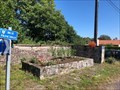
 view gallery view gallerySE24.9 km | Lavoir - Place de la Fontaine - Selles - Haute-Saône (70) - France in Lavoir (wash houses) A lavoir on Place de la Fontaine in Selles, Haute-Saône (70), France. posted by: ntpayne location: Grand-Est, France date approved: 09/08/2021 last visited: never |
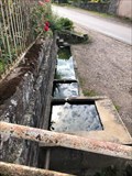
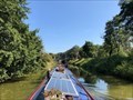
 view gallery view gallerySE25.3 km | Lavoir - Écluse de Selles - Selles - Haute-Saône (70) - France in Lavoir (wash houses) A lavoir by the écluse on the Canal des Vosges in Selles, Haute-Saône (70), France. posted by: ntpayne location: Grand-Est, France date approved: 09/08/2021 last visited: never |
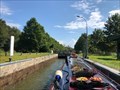
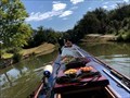
 view gallery view galleryS25.3 km |  Écluse 42 (sud) - Village de Selles - Canal des Vosges - Selles - France Écluse 42 (sud) - Village de Selles - Canal des Vosges - Selles - France
in Waterway Locks, Planes and Lifts This is lock number 42 on the southern slope of the Canal des Vosges and is known as Village de Selles. posted by: ntpayne location: Bourgogne-Franche-Comté, France date approved: 10/19/2021 last visited: never |
 view gallery view gallerySE25.3 km | Écluse 41 (sud) - Carrieres de Selles - Canal des Vosges - Selles - France in Waterway Locks, Planes and Lifts This is lock number 41 on the southern slope of the Canal des Vosges and is known as Carrieres de Selles. posted by: ntpayne location: Bourgogne-Franche-Comté, France date approved: 10/19/2021 last visited: never |
 view gallery view galleryS25.4 km | Lavoir - Chemin de la Patouillette - La Basse Vaivre - Haute-Saône (70) - France in Lavoir (wash houses) A lavoir on Chemin de la Patouillette, La Basse Vaivre in Haute-Saône (70), France. posted by: ntpayne location: Grand-Est, France date approved: 09/08/2021 last visited: never |
 view gallery view galleryS25.6 km | Lavoir - Rue Principale - La Basse Vaivre - Haute-Saône (70) - France in Lavoir (wash houses) A lavoir on Rue Principale, La Basse Vaivre in Haute-Saône (70), France. posted by: ntpayne location: Grand-Est, France date approved: 09/08/2021 last visited: never |
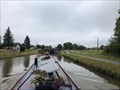
 view gallery view gallerySE25.6 km | Écluse 40 (sud) - Bois de Selles - Canal des Vosges - Selles - France in Waterway Locks, Planes and Lifts This is lock number 40 on the southern slope of the Canal des Vosges and is known as Bois de Selles. posted by: ntpayne location: Bourgogne-Franche-Comté, France date approved: 10/20/2021 last visited: never |
 view gallery view galleryE26.1 km | Écluse 1 - Trusey - Canal des Vosges - Girancourt - France in Waterway Locks, Planes and Lifts This is lock number 1 on the southern slope of the Canal des Vosges and is known as Trusey. posted by: ntpayne location: Grand-Est, France date approved: 11/03/2021 last visited: never |
|