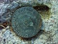
 view gallery view gallery NE0.8 km NE0.8 km
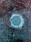
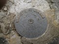
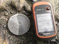
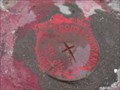
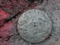
|   Point Geodesique - GEO JC 965 TERRE FORET GT 1973 Val-d'or Point Geodesique - GEO JC 965 TERRE FORET GT 1973 Val-d'or
in Canadian Benchmarks Point Geodesique trouvé durant une recherche de Geocaching a Val-d'or
BenchMark Point found while geocaching in Val-d'or posted by:  FrogMastr FrogMastr location: Québec, Canada date approved: 04/13/2012 last visited: 08/21/2012 |
 view gallery view gallery NW16.6 km NW16.6 km
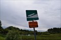
|  Descente de bateau - Val-d'Or-Vassan, Québec Descente de bateau - Val-d'Or-Vassan, Québec
in Boat Ramps une descente de bateau en béton à une voie située sur les rives de la rivière Vassan dans la ville de Val-d'Or-Vassan, au Québec / a single concrete boat ramp located at the banks of Vassan River in the town of Val-d'Or-Vassan, Quebec posted by: oiseau_ca location: Québec, Canada date approved: 07/11/2017 last visited: never |
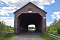
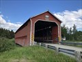 view gallery view galleryNW16.6 km | ") Pont Champagne, Vassan, Québec Pont Champagne, Vassan, Québec
in Histoire du Quebec (Quebec Historical Markers) Le pont Champagne est un pont couvert de type « Town québécois » construit en 1941. Ce pont d'une seule travée mesure 31,8 mètres de long et 7 mètres de large. posted by: blackjack65 location: Québec, Canada date approved: 07/02/2019 last visited: never |
 view gallery view galleryNW16.6 km |  Pont Champagne - Vassan, Québec Pont Champagne - Vassan, Québec
in Wikipedia Entries Le pont Champagne est un pont couvert situé à Vassan, près de Val-d'Or, dans la région administrative de l'Abitibi-Témiscamingue, au Québec, au Canada. Il possède une seule travée de 31,8 m de long et de 7 m de large. posted by: blackjack65 location: Québec, Canada date approved: 07/02/2019 last visited: never |
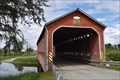 view gallery view galleryNW16.6 km |  Pont Champagne - Chemin du Pont Champagne, Val-d'Or, Québec Pont Champagne - Chemin du Pont Champagne, Val-d'Or, Québec
in Covered Bridges un pont couvert situé à Val-d'Or (Vassan), Québec, Canada / a covered bridge located in Val-d'Or (Vassan), Quebec, Canada posted by: oiseau_ca location: Québec, Canada date approved: 06/28/2017 last visited: 06/29/2019 |
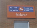 view gallery view gallery W25.7 km W25.7 km
|  Bureau de Poste de Malartic / Malartic Post Office - J0Y 1Z0 Bureau de Poste de Malartic / Malartic Post Office - J0Y 1Z0
in Canada Post Offices Bureau de Poste de Malartic / Malartic Post Office posted by: Papichon location: Québec, Canada date approved: 08/05/2013 last visited: 06/26/2017 |
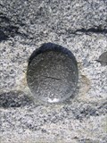
 view gallery view gallery N35.1 km N35.1 km
| Mont-Video BenchMark points geodesique in Canadian Benchmarks Point geodesique et station de triangulation mont-video posted by: FrogMastr location: Québec, Canada date approved: 09/03/2012 last visited: never |
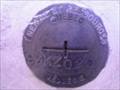
 view gallery view galleryN53.9 km | 82L287 Halte routière Amos in Canadian Benchmarks Disque repère géodésique 82L287, halte routière d'Amos. posted by:  bemarc bemarc location: Québec, Canada date approved: 04/24/2008 last visited: 08/03/2010 |
 view gallery view galleryW55.5 km | Point Geodesique Québec - 79K0403 TERRE FORET in Canadian Benchmarks Point Geodesique trouvé en promenade sous une linge à haute tension posted by: Garnotte13 location: Québec, Canada date approved: 08/22/2012 last visited: never |
 view gallery view galleryW55.7 km | Transport Québec 95KSZ34 in Canadian Benchmarks Transport Québec 95KSZ34 posted by: Garnotte13 location: Québec, Canada date approved: 08/22/2012 last visited: never |
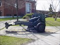 view gallery view galleryNW57.1 km |  Les deux 25 pounder de l'Hotel de ville d'Amos Les deux 25 pounder de l'Hotel de ville d'Amos
in Static Artillery Displays Deux Ordnance QF 25 pounder flanque une stèle en hommage aux anciens combattants devant l'hotel de ville d'Amos.
Two Ordnance QF 25 pounder flanked a monument in tribute to veterans at the City Hall of Amos. posted by: caius location: Québec, Canada date approved: 06/03/2009 last visited: 06/26/2017 |
 view gallery view galleryNW57.9 km | Bureau de Poste d'Amos / Amos Post Office - J9T 1T8 in Canada Post Offices Bureau de Poste d'Amos / Amos Post Office posted by: Papichon location: Québec, Canada date approved: 08/05/2013 last visited: never |
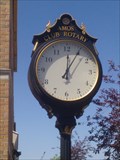 view gallery view galleryNW58.1 km |  Horloge Rotary - Amos, Québec Horloge Rotary - Amos, Québec
in Rotary International Markers Horloge donné par le Club Rotary posted by: Papichon location: Québec, Canada date approved: 07/31/2013 last visited: 06/01/2014 |
 view gallery view galleryNW62.8 km | Camp d'Internement de Spirit Lake - Spirit Lake Internement Camp in Histoire du Quebec (Quebec Historical Markers) Camp d'Internement de Spirit Lake - Spirit Lake Internment Camp posted by: Papichon location: Québec, Canada date approved: 08/16/2013 last visited: never |
 view gallery view galleryW69.8 km | 95KSZ21 Côte Joannès in Canadian Benchmarks Transport Québec 95KSZ21 posted by: Garnotte13 location: Québec, Canada date approved: 09/25/2012 last visited: never |
 view gallery view galleryN76 km | Pont Alphonse-Normandin - Saint-Dominique-du-Rosaire, Québec in Covered Bridges un pont couvert situé à Saint-Dominique-du-Rosaire, Québec / a covered bridge located in Saint-Dominique-du-Rosaire, Quebec posted by: oiseau_ca location: Québec, Canada date approved: 06/21/2017 last visited: never |
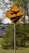 view gallery view galleryW77.2 km |  Survol des avions - Autoroute 117, Rouyn-Noranda, Québec Survol des avions - Autoroute 117, Rouyn-Noranda, Québec
in Uncommon Crossing Signs un panneau de signalisation représentant un avion situé sur l'autoroute 117 dans le nord du Québec - a plane crossing sign located on highway 117 in the north of Quebec posted by: oiseau_ca location: Québec, Canada date approved: 09/19/2014 last visited: 08/15/2023 |
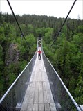 view gallery view galleryNW79.2 km |  Pont suspendu du Lac Lahaie - Abitibi, Qc, Canada Pont suspendu du Lac Lahaie - Abitibi, Qc, Canada
in Pedestrian Suspension Bridges The "Pont suspendu du Lac Lahaie" is a part of the hiking trails located in the "Parc d'Aiguebelle". posted by: tatie location: Québec, Canada date approved: 02/11/2012 last visited: 07/05/2013 |
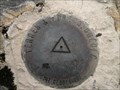
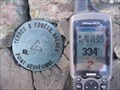
 view gallery view galleryW90.8 km | Parc Terry Fox in Canadian Benchmarks Un point Géodésique situé sur cap de roche dans un parc de Rouyn-Noranda posted by: Garnotte13 location: Québec, Canada date approved: 10/11/2012 last visited: never |
 view gallery view galleryW91.2 km | Point Géodésique Terre & Forêt, Québec No 80 0484 in Canadian Benchmarks Point Géodésique posted by: Les Rois de pique location: Québec, Canada date approved: 09/07/2011 last visited: never |
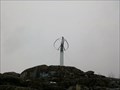 view gallery view galleryW91.9 km |  Éolienne du Cap d'Ours Éolienne du Cap d'Ours
in Windmills [FR] L’éolienne du Cap d’Ours est un aérogénérateur à axe vertical de 200 kW qui fut construit en 2004.
[EN] The Cap d'Ours vertical axis aeolian windmill was built in 2004 and can generate 200 kW of power. posted by: alynx location: Québec, Canada date approved: 05/04/2017 last visited: 06/26/2017 |
 view gallery view galleryW91.9 km | Éolienne in Canadian Benchmarks Point Géodésique Près de Éolienne de UQAT posted by: Garnotte13 location: Québec, Canada date approved: 10/11/2012 last visited: 07/24/2013 |
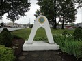 view gallery view galleryW92.2 km |  L'Arche de l'amitié - Rouyn-Noranda (Qc) Canada L'Arche de l'amitié - Rouyn-Noranda (Qc) Canada
in Lions Clubs International Markers l'Arche de l'Amitié du club des Lions situé sur l'autoroute 117 à Rouyn-Noranda (Qc) Canada - a Lions Friendship Arch located on highway 117 in the city of Rouyn-Noranda (Qc) Canada posted by: oiseau_ca location: Québec, Canada date approved: 08/16/2014 last visited: 06/26/2017 |
 view gallery view galleryW92.9 km | 93KZ020 Hotel de Ville in Canadian Benchmarks Hotel de Ville Rouyn-Noranda posted by: Garnotte13 location: Québec, Canada date approved: 09/25/2012 last visited: never |
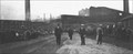 view gallery view galleryW92.9 km |  Mine Noranda Mine Noranda
in Photos Then and Now L'entrée de la mine Noranda à Rouyn-Noranda. // Noranda mine entrance in Rouyn Noranda. posted by: Le Moog location: Québec, Canada date approved: 01/30/2006 last visited: 06/26/2017 |
|