 view gallery view gallery S2.9 km S2.9 km
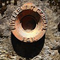
|   A.D.N3 - 86 / 942,067 m A.D.N3 - 86 / 942,067 m
in French Benchmarks Repère cylindrique du nivellement général IGN type M, Col de Rimbach Hundsruck, MOLLAU, Alsace, France posted by:  CrAzYoTa CrAzYoTa location: Grand-Est, France date approved: 08/27/2016 last visited: never |
 view gallery view gallery NE3.5 km NE3.5 km
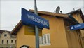
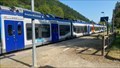
|  Wesserling, France Wesserling, France
in Train Stations/Depots Wesserling station is a railway station in the French commune of Fellering in the Haut-Rhin department in Alsace posted by: superstein location: Grand-Est, France date approved: 10/24/2016 last visited: never |
 view gallery view gallery NW6.1 km NW6.1 km
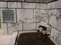
|  Bussang origin's - Moselle - France Bussang origin's - Moselle - France
in Natural Springs This is the origin water of the Moselle posted by:  DD Drix DD Drix location: Grand-Est, France date approved: 02/21/2015 last visited: 03/30/2018 |
 view gallery view gallery E6.3 km E6.3 km
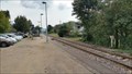
| Moosch, France in Train Stations/Depots Moosch Train station is a French train station of the line of Lutterbach in Kruth on the territory of the town of Moosch in the department of Haut-Rhin in the Alsace region. posted by: superstein location: Grand-Est, France date approved: 09/30/2016 last visited: never |
 view gallery view gallery N6.3 km N6.3 km
| Kruth - La gare - Alsace - France in Train Stations/Depots [FR] La gare terminus du prolongement de la ligne Mulhouse - Thann
[EN The terminus station of the Mulhouse - Thann line extension posted by: Brimbaloup location: Grand-Est, France date approved: 05/31/2023 last visited: never |
 view gallery view galleryE6.8 km |  Geishouse weather station. Geishouse weather station.
in Weather Stations Weather station close to the town of 'Geishouse' posted by: superstein location: Grand-Est, France date approved: 01/02/2017 last visited: never |
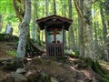 view gallery view gallery SE6.9 km SE6.9 km
|  ROSSBERG's Altar, Alsace, France ROSSBERG's Altar, Alsace, France
in Outdoor Altars Outdoor altar with a beautiful carved wooden cross posted by: CrAzYoTa location: Grand-Est, France date approved: 08/25/2016 last visited: never |
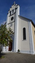 view gallery view galleryE7.1 km |  L'église Saint-Sébastien - Geishouse - France L'église Saint-Sébastien - Geishouse - France
in Roman Catholic Churches L'église Saint-Sébastien is a Roman Catholic churche in the town of Geishouse posted by: superstein location: Grand-Est, France date approved: 02/13/2021 last visited: never |
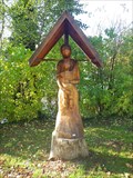 view gallery view galleryE8 km |  "The virgin and the child Jesus", Willer-sur-Thur, Alsace, France "The virgin and the child Jesus", Willer-sur-Thur, Alsace, France
in Outside Wooden Display Carvings Wooden carving of "The virgin and the child Jesus" in a very pleasant park posted by: CrAzYoTa location: Grand-Est, France date approved: 11/13/2016 last visited: never |
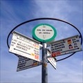
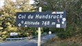 view gallery view gallerySE8.7 km |  Col du Hundsruck (748 meters), France Col du Hundsruck (748 meters), France
in Elevation Signs Top of the mountain Col du Hundsruck posted by: superstein location: Grand-Est, France date approved: 10/27/2016 last visited: never |
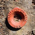 view gallery view gallerySE8.9 km | A.D.N3 - 112 / 744,284 m in French Benchmarks Repère cylindrique du nivellement général IGN type M, Col du Hundsruck, BOURBACH-LE-HAUT, Alsace, France posted by: CrAzYoTa location: Grand-Est, France date approved: 08/27/2016 last visited: never |
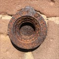 view gallery view gallerySE9.5 km | A.J.P3 - 56 / 358,771 m in French Benchmarks Repère cylindrique du nivellement général IGN, type M, Mairie, Bitschwiller-lès-Thann, Haut-Rhin/FR posted by: CrAzYoTa location: Grand-Est, France date approved: 04/19/2017 last visited: never |
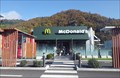 view gallery view gallerySE10.1 km |  McDonald's Bitschwiller-lès-Thann - Alsace, France McDonald's Bitschwiller-lès-Thann - Alsace, France
in McDonald's Restaurants in a commercial area, Open 7/7 from 10 to 22:30 posted by: CrAzYoTa location: Grand-Est, France date approved: 11/25/2016 last visited: never |
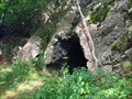 view gallery view galleryNE10.1 km | ") Cave of Col du Hagg, Alsace, France Cave of Col du Hagg, Alsace, France
in Cave Entrances (Artificial) Small man made cave, located above the highest peak (Le Grand Ballon 1424 m (4672 ft)) of the Vosges montaines posted by: CrAzYoTa location: Grand-Est, France date approved: 09/12/2016 last visited: never |
 view gallery view galleryNE10.1 km | Col du HAAG, Vosges, France - 1233m (4045ft) in Elevation Signs The pass of the haag can be find in the intersection of the famous road of crests (La route des Crêtes) with the road of Geishouse. posted by: CrAzYoTa location: Grand-Est, France date approved: 09/08/2016 last visited: never |
 view gallery view gallery SW10.3 km SW10.3 km
|  Ballon d'Alsace - Sewen (Haut-Rhin), France Ballon d'Alsace - Sewen (Haut-Rhin), France
in Mountain Summits [FR] Le ballon d’Alsace est un sommet situé dans la partie méridionale de la chaîne des Vosges. [EN] From its top, views include the Vosges, the Rhine valley, the Black Forest, and the Alps. posted by: RakeInTheCache location: Grand-Est, France date approved: 10/11/2021 last visited: never |
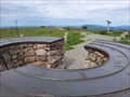 view gallery view gallerySW10.3 km |  Ballon d'Alsace - Sewen (Haut-Rhin), France Ballon d'Alsace - Sewen (Haut-Rhin), France
in Orientation Tables [FR] Le ballon d’Alsace est un sommet situé dans la partie méridionale de la chaîne des Vosges. [EN] From its top, views include the Vosges, the Rhine valley, the Black Forest, and the Alps. posted by: RakeInTheCache location: Grand-Est, France date approved: 10/13/2021 last visited: never |
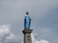 view gallery view gallerySW10.5 km |  La Vierge Marie-Ballon d'Alsace-Lorraine,France La Vierge Marie-Ballon d'Alsace-Lorraine,France
in Statues of Religious Figures Une belle Vierge! A beautiful Virgin! posted by: gemeloj location: Grand-Est, France date approved: 03/26/2015 last visited: never |
 view gallery view gallerySW10.5 km | Le PUIX 1-Ballon d'Alsace-France in French Benchmarks Une Vierge pour repère! posted by: gemeloj location: Grand-Est, France date approved: 11/21/2014 last visited: never |
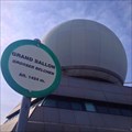
 view gallery view galleryE10.5 km |  HIGHEST peak in the Vosges, Grand Ballon - Alsace / France HIGHEST peak in the Vosges, Grand Ballon - Alsace / France
in Superlatives The highest mountain of the Vosges, come up ;-) posted by: Iris & Harry location: Grand-Est, France date approved: 09/26/2016 last visited: 09/03/2016 |
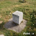 view gallery view galleryE10.5 km | ALTENBACH A - 68003A - point a (Le Grand Ballon) in French Benchmarks Point a du Grand Ballon, Site du Réseau de détail, Alsace, France.
"French Benchmark" le plus haut des Vosges 1424m (4672 ft) posted by: CrAzYoTa location: Grand-Est, France date approved: 09/23/2016 last visited: 09/17/2014 |
 view gallery view galleryE10.5 km | Grand Ballon - Vosges - France. 1424 m (4672 ft) in Elevation Signs Le Grand-Ballon, with summit in 1424 m (4672 ft) altitude, is not only the highest summit in the Vosges mountains but also is the highest point of the Alsace French region (Région Alsace). posted by: CrAzYoTa location: Grand-Est, France date approved: 09/04/2016 last visited: 09/17/2014 |
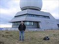 view gallery view galleryE10.5 km | Grand Ballon, Alsace in Mountain Summits [FR] Le Grand Ballon est le point culminant du massif des Vosges, situé à 25 km au Nord-Ouest de Mulhouse. [EN] Le Grand Ballon is the highest peak of the Vosges mountains, located 25 kilometres northwest of Mulhouse, France. posted by: RakeInTheCache location: Grand-Est, France date approved: 05/16/2008 last visited: 10/11/2021 |
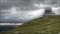 view gallery view galleryE10.5 km |  Grand Ballon - Vosges Mountains (Alsace, France) Grand Ballon - Vosges Mountains (Alsace, France)
in Wikipedia Entries Le Grand-Ballon is not only the highest summit in the Vosges mountains but also is the highest point of the Alsace French region (Région Alsace). posted by: Dorcadion Team location: Grand-Est, France date approved: 11/11/2013 last visited: 09/03/2016 |
 view gallery view galleryE10.5 km |  Le Grand Ballon - Vosges Mountains & Région Alsace (France) Le Grand Ballon - Vosges Mountains & Région Alsace (France)
in Geographic High Points Le Grand-Ballon, with summit in 1424 m altitude, is not only the highest summit in the Vosges mountains but also is the highest point of the Alsace French region (Région Alsace). posted by: Dorcadion Team location: Grand-Est, France date approved: 11/13/2013 last visited: 09/03/2016 |
|