 view gallery view gallery S0.2 km S0.2 km
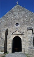
|   Église Notre-Dame de Kerdro - Locmariaquer, France Église Notre-Dame de Kerdro - Locmariaquer, France
in This Old Church [EN] In 1082, the monks of Redon undertook the construction of the priory and parochial church.
[FR] En 1082, les moines de Redon entreprennent la construction de l’église prieurale et paroissiale. posted by:  pmaupin pmaupin location: Bretagne, France date approved: 06/23/2017 last visited: 09/15/2021 |
 view gallery view galleryS0.2 km | Église Notre-Dame de Kerdro - Locmariaquer, France in Roman Catholic Churches [EN] In 1082, the monks of Redon undertook the construction of the priory and parochial church. [FR] En 1082, les moines de Redon entreprennent la construction de l’église prieurale et paroissiale. posted by: pmaupin location: Bretagne, France date approved: 07/27/2018 last visited: 09/15/2021 |
 view gallery view galleryS0.2 km |  Église Notre-Dame de Kerdro - Locmariaquer (Morbihan), France Église Notre-Dame de Kerdro - Locmariaquer (Morbihan), France
in Romanesque Architecture [EN] In 1082, the monks of Redon undertook the construction of the priory and parochial church. [FR] En 1082, les moines de Redon entreprennent la construction de l’église prieurale et paroissiale. posted by: pmaupin location: Bretagne, France date approved: 07/26/2018 last visited: 09/15/2021 |
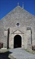
 view gallery view galleryS0.2 km |  Église Notre-Dame - Locmariaquer, France Église Notre-Dame - Locmariaquer, France
in Wikipedia Entries [EN] In 1082, the monks of Redon undertook the construction of the priory and parochial church.
[FR] En 1082, les moines de Redon entreprennent la construction de l’église prieurale et paroissiale. posted by: pmaupin location: Bretagne, France date approved: 06/25/2017 last visited: 09/15/2021 |
 view gallery view galleryS0.2 km |  Église Notre-Dame de Kerdro - Locmariaquer, France Église Notre-Dame de Kerdro - Locmariaquer, France
in Monuments Historiques Français [FR] En 1082, les moines de Redon entreprennent la construction de l’église prieurale et paroissiale.
[EN] In 1082, the monks of Redon undertook the construction of the priory and parochial church. posted by: pmaupin location: Bretagne, France date approved: 06/23/2017 last visited: 09/18/2021 |
 view gallery view galleryS0.2 km |  Église Notre-Dame de Kerdro - Locmariaquer, France Église Notre-Dame de Kerdro - Locmariaquer, France
in Medieval Churches [EN] In 1082, the monks of Redon undertook the construction of the priory and parochial church.
[FR] En 1082, les moines de Redon entreprennent la construction de l’église prieurale et paroissiale. posted by: pmaupin location: Bretagne, France date approved: 06/23/2017 last visited: 09/15/2021 |
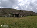
 view gallery view gallery NW0.5 km NW0.5 km
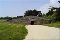
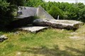
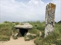
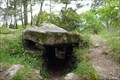
|  Table des Marchand, Locmariaquer, Morbihan, FRA Table des Marchand, Locmariaquer, Morbihan, FRA
in Megalithic Monuments La Table des Marchand (An Daol Varchant in Breton) is a large dolmen located on the megalithic site of Locmariaquer (the Groh), in the French department of Morbihan. posted by: André de Montbard location: Bretagne, France date approved: 11/23/2020 last visited: never |
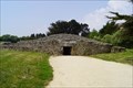 view gallery view galleryNW0.5 km | Table des Marchand, Locmariaquer, France in Monuments Historiques Français La Table des Marchand (An Daol Varchant en breton) est un vaste dolmen situé sur le site mégalithique de Locmariaquer.
-
La Table des Marchand (An Daol Varchant in Breton) is a large dolmen located on the megalithic site of Locmariaquer. posted by: André de Montbard location: Bretagne, France date approved: 11/21/2020 last visited: 09/19/2021 |
 view gallery view gallery W0.5 km W0.5 km
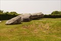
| Grand menhir brisé d'Er Grah - Locmariaquer, France in Monuments Historiques Français Le Grand menhir brisé d'Er Grah, est un menhir de dimensions exceptionnelles, le plus grand d'Europe.
-
The Great Broken Menhir of Er Grah is a menhir of exceptional dimensions, the largest in Europe. posted by: André de Montbard location: Bretagne, France date approved: 11/21/2020 last visited: 09/19/2021 |
 view gallery view galleryW0.5 km | Grand menhir brisé d'Er Grah - Locmariaquer, Morbihan, FRA in Megalithic Monuments The Large Broken Menhir of Er Grah, or Men ar hroëc'h which means "Stone of the Fairy" in Breton, located on the territory of the municipality of Locmariaquer, in Morbihan. posted by: André de Montbard location: Bretagne, France date approved: 11/23/2020 last visited: 09/19/2021 |
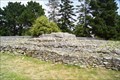 view gallery view galleryNW0.5 km | Tumulus d'Er Grah - Locmariaquer, Morbihan, FRA in Megalithic Monuments The Er grah Tumulus is a megalith dating from the Neolithic period, located in the town of Locmariaquer, in the Gulf of Morbihan. posted by: André de Montbard location: Bretagne, France date approved: 11/23/2020 last visited: never |
 view gallery view galleryNW0.6 km | Tumulus d'Er Grah - Locmariaquer, France in Monuments Historiques Français Le Tumulus d'Er grah est un mégalithe datant du Néolithique, situé sur la commune de Locmariaquer.
-
The Er grah Tumulus is a megalith dating from the Neolithic period, located in the town of Locmariaquer. posted by: André de Montbard location: Bretagne, France date approved: 11/22/2020 last visited: never |
 view gallery view galleryNW0.6 km | Tumulus du Mané-Lud - Locmariaquer, France in Monuments Historiques Français Le tumulus du Mané-Lud (ou dolmen de Mane-Lud) situé sur la commune de Locmariaquer, dans le golfe du Morbihan.
-
The Mané-Lud tumulus (or Mane-Lud dolmen) located in the town of Locmariaquer, in the Gulf of Morbihan. posted by: André de Montbard location: Bretagne, France date approved: 11/22/2020 last visited: 09/19/2021 |
 view gallery view galleryNW0.6 km | Tumulus du Mané-Lud - Locmariaquer, Morbihan, FRA in Megalithic Monuments The Mané-Lud tumulus (or Mane-Lud dolmen) located in the town of Locmariaquer, in the Gulf of Morbihan. posted by: André de Montbard location: Bretagne, France date approved: 11/23/2020 last visited: 09/19/2021 |
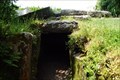
 view gallery view galleryS1.6 km | Dolmen des Pierres-Plates, Locmariaquer, France in Monuments Historiques Français Le monument mégalithique des Pierres-Plates est un Dolmen à Locmariaquer dans le Morbihan.
-
The megalithic monument of Pierres-Plates is a Dolmen at Locmariaquer in Morbihan. posted by: André de Montbard location: Bretagne, France date approved: 11/21/2020 last visited: 12/19/2022 |
 view gallery view galleryS1.6 km | Dolmen des Pierres-Plates, Locmariaquer, Morbihan, FRA in Megalithic Monuments The megalithic monument of Pierres-Plates (Breton: ar Vein Plat) is located in Locmariaquer in Morbihan in Brittany (France). It is near La Falaise Beach. posted by: André de Montbard location: Bretagne, France date approved: 11/23/2020 last visited: 12/19/2022 |
 view gallery view gallery SE3.1 km SE3.1 km
|  Arzon : Jetée de Port-Navalo Arzon : Jetée de Port-Navalo
in French Benchmarks Jetée à Port-Navalo posted by: garenkreiz location: Bretagne, France date approved: 05/29/2013 last visited: 10/04/2021 |
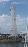
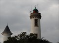 view gallery view gallerySE3.1 km |  Phare de Port Navalo, France Phare de Port Navalo, France
in Coastal Lighthouses Phare à Port-Navalo, commune d'Arzon sur la presqu'ile de Rhuys.
Lighthouse at Port-Navalo on the Rhuys peninsula. posted by: garenkreiz location: Bretagne, France date approved: 05/29/2013 last visited: 10/04/2021 |
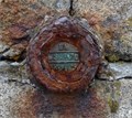
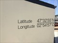 view gallery view gallerySE3.2 km |  47° 32' 55" N 02° 54' 57" O - Port Navalo, Arzon, FRA 47° 32' 55" N 02° 54' 57" O - Port Navalo, Arzon, FRA
in Permanent Geographic Coordinates [FR] Coordonnées permanentes sur le mur d'un bâtiment de Port Navalo, dans la ville d'Arzon, France.
[EN] Permanent coordinates on the wall of a building of Port Navalo, in the city of Arzon, France. posted by: ipln location: Bretagne, France date approved: 09/01/2021 last visited: 12/19/2022 |
 view gallery view gallery NE3.5 km NE3.5 km
| Dolmen de Toulvern in Megalithic Monuments Les dolmens de Toulvern sont situés sur la commune de Baden, Bretagne, France posted by: celene37 location: Bretagne, France date approved: 02/10/2015 last visited: 02/10/2015 |
 view gallery view galleryNE4.3 km |  boite a livre Larmor-Baden boite a livre Larmor-Baden
in Free Community Book Exchanges boite a livre de Larmor Baden.
book box of Larmor Baden. posted by: keillec location: Bretagne, France date approved: 12/28/2018 last visited: 12/28/2018 |
 view gallery view gallerySE4.7 km | NOT LANDLOCKED - Phare de Port-Navalo - Port-Navalo, Bretagne in Landlocked Lighthouses [FR] Ce phare se trouve dans la baie de la presqu'île de Rhuys.
[EN] This lighthouse is located in the bay of Rhuys peninsula. posted by: Tromel location: Bretagne, France date approved: 09/04/2018 last visited: 12/19/2022 |
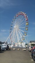 view gallery view gallerySE4.8 km |  La grande roue d'Arzon - Arzon, Bretagne La grande roue d'Arzon - Arzon, Bretagne
in Ferris Wheels [FR] Grande roue située en été sur le port d'Arzon.
[EN] Ferris wheel located in summer on the port of Arzon. posted by: Tromel location: Bretagne, France date approved: 09/04/2018 last visited: 10/04/2021 |
 view gallery view gallerySE4.8 km |  Port de la presqu'île de Rhuys - Arzon, Bretagne, France Port de la presqu'île de Rhuys - Arzon, Bretagne, France
in Flags of the World [FR] Les drapeaux de différents pays tout près du port de la commune, devant la capitainerie.[EN] The flags of different countries near the port of the town, in front of the captaincy. posted by: Tromel location: Bretagne, France date approved: 09/06/2018 last visited: 10/04/2021 |
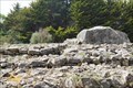
 view gallery view gallerySE4.8 km |  Le Petit-Mont - Arzon, Bretagne, France Le Petit-Mont - Arzon, Bretagne, France
in Cairns [FR] Le Petit Mont est un cairn situé en Bretagne [EN] The "Petit Mont" is a cairn located in Britany posted by: Tromel location: Bretagne, France date approved: 07/29/2021 last visited: 12/18/2021 |
|