 view gallery view gallery NW10.8 km NW10.8 km
|   Hot Springs, MT 59845 Hot Springs, MT 59845
in U.S. Post Offices Located at 111 SPRING ST HOT SPRINGS, MT 59845-9722 posted by:  nomadwillie nomadwillie location: Montana date approved: 01/06/2013 last visited: never |
 view gallery view gallery E11.9 km E11.9 km
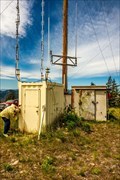
|  Oliver Point Repeater--Sanders County, Montana Oliver Point Repeater--Sanders County, Montana
in Amateur Radio Repeaters Oliver Point is one of the higher peaks in the eastern Cabinet Mountains. The site is home to a repeater used by the Sanders County 911 system as well as a privately owned ham repeater. posted by:  mtbearded1 mtbearded1 location: Montana date approved: 07/22/2020 last visited: never |
 view gallery view gallery SW18 km SW18 km
|  Closing Corner Secs 25 & 26 (T20N, R25W, P.M.) Closing Corner Secs 25 & 26 (T20N, R25W, P.M.)
in Public Land Survey Marks Found USFS Mon. with an original GLO Bearing Tree posted by: stevebratz location: Montana date approved: 06/15/2011 last visited: never |
 view gallery view gallery S19.2 km S19.2 km
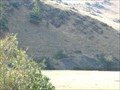
|  Camas Prairie Wave Lines - Montana Camas Prairie Wave Lines - Montana
in Glacial Lake Missoula Flood Features The wave line cuts were made during the draining of Lake Missoula and are located along MT Hwy 382. posted by:  BruceS BruceS location: Montana date approved: 08/05/2007 last visited: never |
 view gallery view galleryS26.2 km |  Perma Bridge - Dixon, MT Perma Bridge - Dixon, MT
in Railroad Bridges This is another four span truss bridge, this one over the Flathead River 17 miles west of Dixon, MT. in Sanders County. posted by: T0SHEA location: Montana date approved: 12/02/2014 last visited: never |
 view gallery view galleryS26.2 km |  Perma Bridge - Dixon, MT Perma Bridge - Dixon, MT
in Truss Bridges This is another four span truss bridge, this one over the Flathead River 17 miles west of Dixon, MT. in Sanders County. posted by: T0SHEA location: Montana date approved: 11/16/2014 last visited: never |
 view gallery view gallery NE26.4 km NE26.4 km
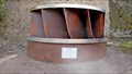
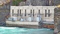
|  Francis Turbine - Polson, MT Francis Turbine - Polson, MT
in Preserved Machines on Public Display This turbine has been put on display at the Kerr Dam beside the maintenance buildings. It is within site of the powerhouse in which it spun for 52 years. posted by: T0SHEA location: Montana date approved: 07/05/2014 last visited: never |
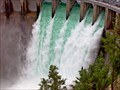
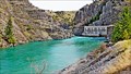
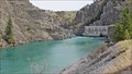 view gallery view galleryNE26.4 km |  Kerr Dam - Polson, MT Kerr Dam - Polson, MT
in Hydroelectric Power Stations Put into operation in 1938, the Kerr dam is a concrete arch dam 541 feet long and 205 feet high. The power house is 1700 feet away, with its water supply arriving through three penstocks running through solid rock. posted by: T0SHEA location: Montana date approved: 05/21/2014 last visited: never |
 view gallery view galleryNE26.4 km |  Kerr Dam - Polson, MT Kerr Dam - Polson, MT
in Lucky 7 Put into operation in 1938, the Kerr dam is a concrete arch dam 541 feet long and 205 feet high. The power house is 1700 feet away, with its water supply arriving through three penstocks running through solid rock. posted by: T0SHEA location: Montana date approved: 04/02/2017 last visited: never |
 view gallery view galleryNE26.4 km |  Kerr Dam - Polson, MT Kerr Dam - Polson, MT
in Official Local Tourism Attractions Put into operation in 1938, the Kerr dam is a concrete arch dam 541 feet long and 205 feet high. The power house is 1700 feet away, with its water supply arriving through three penstocks running through solid rock. posted by: T0SHEA location: Montana date approved: 05/25/2014 last visited: never |
 view gallery view galleryNE26.4 km |  Kerr Dam - Polson, MT Kerr Dam - Polson, MT
in Man-made Waterfalls Put into operation in 1938, the Kerr dam is a concrete arch dam 541 feet long and 205 feet high. The power house is 1700 feet away, with its water supply arriving through three penstocks running through solid rock. posted by: T0SHEA location: Montana date approved: 05/24/2014 last visited: never |
 view gallery view galleryNE26.4 km |  Kerr Dam - Polson, MT Kerr Dam - Polson, MT
in Wikipedia Entries Put into operation in 1938, the Kerr dam is a concrete arch dam 541 feet long and 205 feet high. The power house is 1700 feet away, with its water supply arriving through three penstocks running through solid rock. posted by: T0SHEA location: Montana date approved: 05/22/2014 last visited: never |
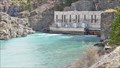
 view gallery view galleryNE26.4 km |  Flathead Dam (Kerr Dam) - Polson, MT Flathead Dam (Kerr Dam) - Polson, MT
in American Guide Series Put into operation in 1938, the Kerr dam is a concrete arch dam 541 feet long and 205 feet high. The power house is 1700 feet away, with its water supply arriving through three penstocks running through solid rock. posted by: T0SHEA location: Montana date approved: 02/17/2016 last visited: never |
 view gallery view galleryNE26.4 km |  Kerr Dam - Polson, MT Kerr Dam - Polson, MT
in Water Dams Put into operation in 1938, the Kerr dam is a concrete arch dam 541 feet long and 205 feet high. The power house is 1700 feet away, with its water supply arriving through three penstocks running through solid rock. posted by: T0SHEA location: Montana date approved: 05/22/2014 last visited: never |
 view gallery view galleryNE26.4 km |  Kerr Dam - Polson, MT Kerr Dam - Polson, MT
in People-Named Places Put into operation in 1938, the Kerr dam is a concrete arch dam 541 feet long and 205 feet high. The power house is 1700 feet away, with its water supply arriving through three penstocks running through solid rock. posted by: T0SHEA location: Montana date approved: 03/27/2017 last visited: never |
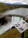
 view gallery view galleryNE26.4 km |  Clock ticking down to Kerr Dam's historic takeover by Indian tribes Clock ticking down to Kerr Dam's historic takeover by Indian tribes
in News Article Locations Put into operation in 1938, the Kerr dam is a concrete arch dam 541 feet long and 205 feet high. The power house is 1700 feet away, with its water supply arriving through three penstocks running through solid rock. posted by: T0SHEA location: Montana date approved: 03/29/2017 last visited: never |
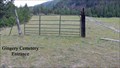 view gallery view gallerySW26.7 km |  Gingery Cemetery - Paradise, Montana Gingery Cemetery - Paradise, Montana
in Worldwide Cemeteries Gingery Cemetery: As a reference, at the junction of Hwy. 200 and Hwy. 135 continue W on Hwy. 200, 7 km. or from the junction of Hwy. 200 and Hwy. 382 continue E on Hwy. 200, 10 km. There is a gate across the dirt road. Park and walk to cemetery. posted by: T0SHEA location: Montana date approved: 06/30/2014 last visited: never |
 view gallery view gallerySW26.9 km |  Henry & Delta Dykstra - Paradise, Montana Henry & Delta Dykstra - Paradise, Montana
in Dedicated Benches To find the Paradise Cemetery: From Hwy. 200 turn east on 1st Street at the "T" turn south on North Avenue to cemetery, 250 meters posted by: T0SHEA location: Montana date approved: 07/14/2014 last visited: never |
 view gallery view gallerySW26.9 km | Paradise Cemetery - Paradise, Montana in Worldwide Cemeteries To find the Paradise Cemetery: From Hwy. 200 turn east on 1st Street at the "T" turn south on North Avenue to cemetery, 250 meters. posted by: T0SHEA location: Montana date approved: 06/30/2014 last visited: 09/01/2014 |
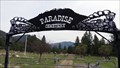
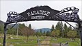 view gallery view gallerySW26.9 km |  Paradise Cemetery - Paradise, Montana Paradise Cemetery - Paradise, Montana
in Freestanding Arches To find the Paradise Cemetery: From Highway 200 turn east on 1st Street at the south end of Paradise, then turn south on North Avenue to the cemetery, 250 meters away. posted by: T0SHEA location: Montana date approved: 11/16/2014 last visited: never |
 view gallery view gallerySW26.9 km |  Paradise Elementary School Bell Tower - Paradise, MT Paradise Elementary School Bell Tower - Paradise, MT
in Bell Towers This bell in the tower of this historic old school had called the children of the little village of Paradise, Montana to class for 103 years. posted by: T0SHEA location: Montana date approved: 11/17/2014 last visited: never |
 view gallery view gallerySW26.9 km |  Paradise Elementary School Stairs - 1910 - Paradise, MT Paradise Elementary School Stairs - 1910 - Paradise, MT
in Dated Architectural Structures Multifarious This historic old school stands on the southern edge of the little village of Paradise, in Sanders County, western Montana. posted by: T0SHEA location: Montana date approved: 11/17/2014 last visited: never |
 view gallery view gallerySW26.9 km |  Paradise Elementary School - Paradise, MT Paradise Elementary School - Paradise, MT
in Former Schools This historic old school stands on the southern edge of the little village of Paradise, in Sanders County, western Montana. posted by: T0SHEA location: Montana date approved: 11/17/2014 last visited: 04/07/2020 |
 view gallery view gallerySW26.9 km | Paradise School fading into history - Paradise, MT in News Article Locations This historic old school stands on the southern edge of the little village of Paradise, in Sanders County, western Montana. posted by: T0SHEA location: Montana date approved: 11/16/2014 last visited: never |
 view gallery view gallery W27 km W27 km
| Memorial Day Flags Erected in Plains in News Article Locations To find the Plains Cemetery: From Highway 200 north of Plains turn west on Kruger Road and continue 700 meters then turn north on Clayton Road. In 250 meters you will see a dirt road. Take this to the Cemetery another 200 meters NW. posted by: T0SHEA location: Montana date approved: 05/26/2019 last visited: never |
|