 view gallery view gallery SE1.1 km SE1.1 km
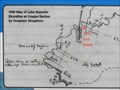
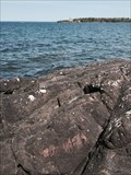
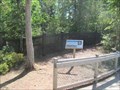
|   The Green Rock - You Are Here Map - Copper Harbor, MI The Green Rock - You Are Here Map - Copper Harbor, MI
in 'You Are Here' Maps The location of the "Green Rock" that started the Michigan copper rush in the 1840's. posted by:  linkys linkys location: Michigan date approved: 09/19/2011 last visited: never |
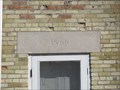 view gallery view gallerySE1.1 km |  1866 - Copper Harbor Lighthouse - Copper Harbor, MI 1866 - Copper Harbor Lighthouse - Copper Harbor, MI
in Dated Buildings and Cornerstones Date above the front door of the historic Copper Harbor Lighthouse. posted by: linkys location: Michigan date approved: 09/16/2011 last visited: 07/13/2016 |
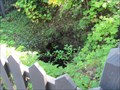
 view gallery view gallerySE1.1 km |  Lighthouse Outhouse - Copper Harbor, MI Lighthouse Outhouse - Copper Harbor, MI
in Outhouses The type of brick in this lighthouse keepers outhouse matches the brick in the lighthouse. posted by: linkys location: Michigan date approved: 09/16/2011 last visited: 08/19/2018 |
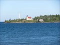
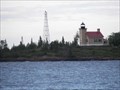 view gallery view gallerySE1.1 km |  Copper Harbor Light House Copper Harbor Light House
in Coastal Lighthouses The Copper Harbor Lighthouse is located within Fort Wilkins Historic State Park at the tip of the Keweenaw Peninsula. posted by:  kJfishman kJfishman location: Michigan date approved: 08/20/2007 last visited: 06/29/2017 |
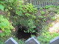
 view gallery view gallerySE1.1 km |  Hays' Point Mine - Copper Harbor, MI Hays' Point Mine - Copper Harbor, MI
in Mines The site of Michigan's first mine shaft is on the same point of land that the "Green Rock" which started the Michigan copper rush is located. posted by: linkys location: Michigan date approved: 09/16/2011 last visited: 08/19/2018 |
 view gallery view gallerySE1.1 km |  FIRST - Commercial Mine Shaft in Michigan - Copper Harbor, MI FIRST - Commercial Mine Shaft in Michigan - Copper Harbor, MI
in First of its Kind Soon after the presence of copper ore in commercially viable concentrations was confirmed, the Pittsburgh and Boston Copper Harbor Mining Company sank this shaft on a point of land known today as Hays' Point. posted by: linkys location: Michigan date approved: 09/17/2011 last visited: never |
 view gallery view gallerySE1.1 km |  Lighthouse Keepers Dwelling - Copper Harbor, MI Lighthouse Keepers Dwelling - Copper Harbor, MI
in Photos Then and Now The Copper Harbor Lighthouse keepers dwelling today looks much as it did a hundred years ago. posted by: linkys location: Michigan date approved: 09/16/2011 last visited: 08/19/2018 |
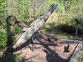 view gallery view gallerySE1.3 km |  Hays' Point Anchor - Copper Harbor, MI Hays' Point Anchor - Copper Harbor, MI
in Anchors Anchor along the path on Hays' Point leading from the boat landing to the Copper Harbor Lighthouse. posted by: linkys location: Michigan date approved: 09/16/2011 last visited: 02/28/2012 |
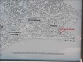 view gallery view gallerySE1.3 km | Hays' Point - You Are Here Map - Copper Harbor, MI in 'You Are Here' Maps This was the place in 1840 where the presence of copper on the Keweenaw Peninsula was confirmed by Douglas Houghton. posted by: linkys location: Michigan date approved: 09/19/2011 last visited: never |
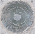
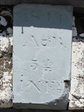
 view gallery view gallery S1.6 km S1.6 km
|  Copper Harbor Astronomic Latitude Mark Copper Harbor Astronomic Latitude Mark
in U.S. Benchmarks Mark on rock on Lake Superior Shore, marked as follows:
Lat. +
47deg23' 11"
O.B.W U.S.L.S.
1864 posted by: Amygdaloid location: Michigan date approved: 06/15/2015 last visited: never |
 view gallery view galleryS1.8 km |  Lighthouse Overlook - Copper Harbor, MI Lighthouse Overlook - Copper Harbor, MI
in Scenic Roadside Look-Outs Located along edge of Copper Harbor, this overlook has plenting of parking and a magnificent view of the historic Copper Harbor Lighthouse on a point of land across the harbor. posted by: linkys location: Michigan date approved: 09/15/2011 last visited: 09/27/2015 |
 view gallery view galleryS1.8 km |  US 41--Fanny Hooe Creek Bridge - Copper Harbor, MI US 41--Fanny Hooe Creek Bridge - Copper Harbor, MI
in U.S. National Register of Historic Places Stone arch bridge over a creek near historic Fort Wilkins in the upper peninsula of Michigan. posted by: linkys location: Michigan date approved: 09/16/2011 last visited: 08/19/2018 |
 view gallery view galleryS1.8 km | J 66 - Copper Harbor, MI in U.S. Benchmarks Located at the southeast end of the historic bridge carrying US Hwy 41 over Fanny Hooe Creek. posted by: linkys location: Michigan date approved: 09/17/2011 last visited: never |
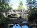 view gallery view galleryS1.8 km |  Fanny Hooe Creek Bridge - Copper Harbor, MI Fanny Hooe Creek Bridge - Copper Harbor, MI
in Arch Bridges Stone arch bridge near the end of the road on the Keweenaw Peninsula of Michigan. posted by: linkys location: Michigan date approved: 09/17/2011 last visited: 08/19/2018 |
 view gallery view galleryS1.9 km | 1844 - Fort Wilkins Powder Magazine - Copper Harbor, MI in Dated Buildings and Cornerstones The powder magazine was one the only buildings in this early Michigan frontier fort not constructed of wood. posted by: linkys location: Michigan date approved: 09/16/2011 last visited: 08/19/2018 |
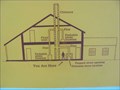 view gallery view galleryS1.9 km | Officer's Quarters You Are Here Map - Copper Harbor, MI in 'You Are Here' Maps With an unusual way of heating the officer's Quarters in this early fort, this Your Are Here Map helps you understand where the various components are within the building. posted by: linkys location: Michigan date approved: 09/17/2011 last visited: never |
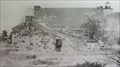
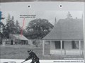 view gallery view galleryS1.9 km | Fort Wilkins Ice House - Copper Harbor, MI in Photos Then and Now Fort Wilkins, abandoned in the late 1860's had stood vacant for mant years when this photo was taken in 1889. posted by: linkys location: Michigan date approved: 09/16/2011 last visited: 08/19/2018 |
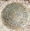 view gallery view galleryS1.9 km | U.S. Coastal & Geooetic Survey Fort Wilkins MI State Park in U.S. Benchmarks U.S. Coastal & Geooetic Survey Fort Wilkins MI State Park posted by: kJfishman location: Michigan date approved: 08/23/2009 last visited: 08/23/2009 |
 view gallery view galleryS1.9 km | Fort Wilkins Mine - Copper Harbor, MI in Mines One of the earliest copper mines in what became known as the Michigan Copper Country. posted by: linkys location: Michigan date approved: 09/16/2011 last visited: 12/20/2012 |
 view gallery view galleryS1.9 km | Fort Wilkins - Copper Harbor, MI in U.S. National Register of Historic Places Historic U.S. military fort located in the Michigan Copper Country. posted by: linkys location: Michigan date approved: 09/16/2011 last visited: 05/04/2016 |
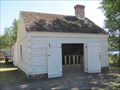 view gallery view galleryS1.9 km |  Fort Wilkins Balcksmith Shop - Copper Harbor, MI Fort Wilkins Balcksmith Shop - Copper Harbor, MI
in Blacksmith Shops Early Military Fort blacksmith shop reconstructed on the site of the original. posted by: linkys location: Michigan date approved: 09/16/2011 last visited: 08/19/2018 |
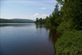 view gallery view galleryS1.9 km |  Lake Fanny Hooe - Copper Harbor MI Lake Fanny Hooe - Copper Harbor MI
in Natural Lakes The lake is 227 acres and is located in Fort Wilkins Historic State Park. posted by: kJfishman location: Michigan date approved: 02/18/2016 last visited: 08/19/2018 |
 view gallery view galleryS1.9 km |  Lake Fanny Hooe - Copper Harbor MI Lake Fanny Hooe - Copper Harbor MI
in Fishing Holes Record Small Mouth Bass have been taken from this lake. Tout, Walleye and Yellow Perch are available. Campgrounds are available near the boat ramp. posted by: kJfishman location: Michigan date approved: 06/04/2016 last visited: 08/19/2018 |
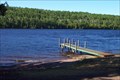 view gallery view galleryS1.9 km |  Lake Fanny Hooe - Copper Harbor MI Lake Fanny Hooe - Copper Harbor MI
in Boat Ramps Lake Fanny Hooe boat ramp in Fort Wilkins State Park - Copper Harbor MI posted by: kJfishman location: Michigan date approved: 05/05/2016 last visited: 08/20/2018 |
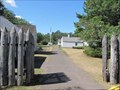
 view gallery view galleryS1.9 km | History Comes Alive - You Are Here - Copper Harbor, MI in 'You Are Here' Maps Nicely done You Are Here Map on the path leading to gates of Fort Wilkins. posted by: linkys location: Michigan date approved: 09/17/2011 last visited: 08/19/2018 |
|