 view gallery view gallery W0.2 km W0.2 km
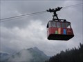
|   Walmendingerhornbahn - Mittelberg, Austria, Vorarlberg Walmendingerhornbahn - Mittelberg, Austria, Vorarlberg
in Aerial Lifts The so-called 'Walmendingerhornbahn' is an aerial lift located at the 'Walmendingerhorn' a mountain in the alps in Austria, Vorarlberg. It is accessable from Mittelberg in the 'Kleinwalsertal'. posted by:  Tante.Hossi Tante.Hossi location: Vorarlberg, Austria date approved: 08/23/2013 last visited: 08/13/2014 |
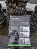
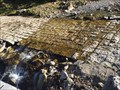
 view gallery view galleryW2.1 km |  Drei Steinmännerbrunnen - Walmendinger Horn - Austria, Vorarlberg Drei Steinmännerbrunnen - Walmendinger Horn - Austria, Vorarlberg
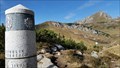
in Fountains This fountain is called 'Drei Steinmännerbrunnen' (Fountain of three stone men). It is located at the mountain station of the 'Walmendingerhornbahn' an arial lift to the summit of the Walmendinger Horn nearby to Mittelberg, Austria, Vorarlberg. posted by: Tante.Hossi location: Vorarlberg, Austria date approved: 08/26/2013 last visited: 08/13/2014 |
 view gallery view galleryW2.1 km |  3 Steinmänner - Walmendinger Horn, Mittelberg, Austria, Vorarlberg 3 Steinmänner - Walmendinger Horn, Mittelberg, Austria, Vorarlberg
in Rock and Mineral Displays At the mountain station of the aerial lift to the summit of the Walmendinger Horn is a small fountain which sets some rocks on a permanent display. posted by: Tante.Hossi location: Vorarlberg, Austria date approved: 08/30/2013 last visited: 08/13/2014 |
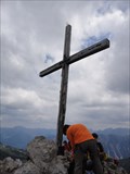
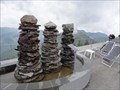 view gallery view galleryW2.1 km |  Drei Steinmänner, Summit of Walmendinger Horn, Austria, Vorarlberg Drei Steinmänner, Summit of Walmendinger Horn, Austria, Vorarlberg
in Cairns At the mountain station of the aerial lift to the summit of the Walmendinger Horn nearby to Mittelberg, Austria, Vorarlberg, is a fountain located which includes three Cairns. posted by: Tante.Hossi location: Vorarlberg, Austria date approved: 08/26/2013 last visited: 08/13/2014 |
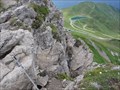
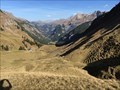
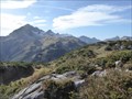
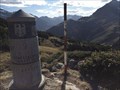
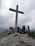 view gallery view galleryW2.1 km |  Walmendinger Horn (1990m) - Austria, Vorarlberg Walmendinger Horn (1990m) - Austria, Vorarlberg
in Mountain Summits The so-called 'Walmendinger Horn' is a mountain in Vorarlberg, Austria. It's elevation is 1990 m (6528 feet). it is accessable by an aerial lift from Mittelberg in the Kleinwalsertal. posted by: Tante.Hossi location: Vorarlberg, Austria date approved: 08/23/2013 last visited: 08/07/2014 |
 view gallery view gallery NE3.9 km NE3.9 km
|  1949m - Zwerenalpe - Riezlern, Austria, Vorarlberg 1949m - Zwerenalpe - Riezlern, Austria, Vorarlberg
in Elevation Signs This elevation sign is at the mountain station of the '6-er Sesselbahn Zwerenalpe'. It is located outside of Riezlern, Austria, Vorarlberg nearby to the summit of the 'Kanzelwand'. posted by: Tante.Hossi location: Vorarlberg, Austria date approved: 11/27/2013 last visited: 02/24/2014 |
 view gallery view gallery E4.2 km E4.2 km
|  Walsersteig - Kanzelwand - Kleinwalsertal, Austria, Vorarlberg Walsersteig - Kanzelwand - Kleinwalsertal, Austria, Vorarlberg
in Established Rock Climbing Areas On top of the mountain 'Kanzelwand' at the Kleinwalsertal in Austria, Vorarlberg exists a Via Ferrata called 'Walsersteig'. You can get access nearby to the montain station of the aerial lift. posted by: Tante.Hossi location: Vorarlberg, Austria date approved: 12/27/2015 last visited: never |
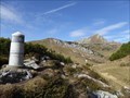
 view gallery view galleryE4.2 km | Kanzelwand (2058m) - Austria, Vorarlberg in Mountain Summits The so-called 'Kanzelwand' is a mountain at the border between Vorarlberg, Austria and Bayern, Germany. It's elevation is 2058 m (6751 feet). It is accessable by an aerial lift from Riezlern in the Kleinwalsertal, Austria. posted by: Tante.Hossi location: Vorarlberg, Austria date approved: 08/27/2013 last visited: 10/17/2018 |
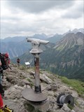 view gallery view galleryE4.2 km |  Mono - Kanzelwand Gipfel/Peak, Germany, BY Mono - Kanzelwand Gipfel/Peak, Germany, BY
in Coin-Op Binoculars This is a monocular located at Peak of the Kanzelwand Mountain nearby to Oberstdorf, Germany, Bayern. posted by: Tante.Hossi location: Bayern, Germany date approved: 07/20/2011 last visited: 10/17/2018 |
 view gallery view galleryNE5.6 km |  TP Fellhorngipfel - Oberstdorf, Germany, BY TP Fellhorngipfel - Oberstdorf, Germany, BY
in German Trigonometric Points This is a German Trigpoint located at the peak of the Fellhorn Mountain near Oberstdorf, Germany, Bayern. posted by: Tante.Hossi location: Bayern, Germany date approved: 07/22/2011 last visited: 10/12/2011 |
 view gallery view gallery SE5.8 km SE5.8 km
|  Untere Biberalp, Oberstdorf, Germany Untere Biberalp, Oberstdorf, Germany
in Bridgeless Water Crossings An der Unteren Biberalp fließt der Haldenwanger Bach quer über die Straße *** Next to a few houses this river crosses the street posted by:  4spring 4spring location: Bayern, Germany date approved: 11/08/2017 last visited: 10/19/2017 |
 view gallery view gallery S5.8 km S5.8 km
|  Trifthütte, Oberstdorf, Germany Trifthütte, Oberstdorf, Germany
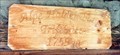
in Named Farms and Ranches Über der Eingangstür hängt das Schild mit dem Namen "Trifthütte" oder vormals "Alpe Haldenwang" *** Above the entrance door is this plaque with the name "Trifthütte" or formerly "Alpe Haldenwang" posted by: 4spring location: Bayern, Germany date approved: 03/03/2018 last visited: 10/19/2017 |
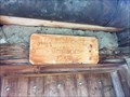 view gallery view galleryS5.8 km | 1759 m, Oberstdorf, Germany in Elevation Signs Über der Eingangstür hängt dieses Schild mit der Höhenangabe *** Above the entrance door is this plaque with the elevation number posted by: 4spring location: Bayern, Germany date approved: 11/08/2017 last visited: 10/19/2017 |
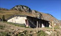 view gallery view galleryS5.8 km |  SOUTHERNMOST - Building in Germany - Oberstdorf, Germany SOUTHERNMOST - Building in Germany - Oberstdorf, Germany
in Superlatives Hier steht das südlichste Gebäude Deutschlands *** This is the southernmost building of Germany - only a short distance from the border to Austria posted by: 4spring location: Germany date approved: 11/22/2017 last visited: 10/19/2017 |
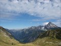 view gallery view galleryS5.8 km |  Haldenwanger Eck, Oberstdorf, Lk Oberallgäu, Germany Haldenwanger Eck, Oberstdorf, Lk Oberallgäu, Germany
in Scenic Overlooks Haldenwanger Eck nahe dem südlichsten Punkt Deutschlands.
---
Haldenwanger Eck near the southest point of germany. posted by: lumbricus location: Bayern, Germany date approved: 07/28/2011 last visited: 10/19/2017 |
 view gallery view galleryS6 km |  Rappenalptal, Oberstdorf, Germany Rappenalptal, Oberstdorf, Germany
in Lucky 7 Das Rappenalptal liegt zwischen dem Grenzstein 147 und Einödsbach *** This Valley starts at the boundary stone # 147 and ends in the small town Einödsbach posted by: 4spring location: Bayern, Germany date approved: 03/11/2018 last visited: 10/19/2017 |
 view gallery view galleryS6.1 km | Gehrner Berg, Oberstdorf, Germany in Mountain Summits Der Gehrner Berg (1936 m) ist der südlichste Berg in Deutschland *** The mountain Gehrner Berg (6351 feet) is the southernmost mountain in Germany posted by: 4spring location: Bayern, Germany date approved: 10/29/2017 last visited: 10/19/2017 |
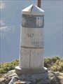
 view gallery view galleryS6.1 km |  Grenzstein 147, Bayern, Tirol, Vorarlberg Grenzstein 147, Bayern, Tirol, Vorarlberg
in Tripoints and Multipoints Der Grenzstein 147 markiert den Dreiländerpunkt, in dem sich die Bundesländer Bayern, Tirol und Vorarlberg treffen *** The boundary stone 147 marks the border triangle of the three federal states Bavaria, Tyrol and Vorarlberg. posted by: 4spring location: Vorarlberg, Austria date approved: 10/31/2017 last visited: 10/19/2017 |
 view gallery view galleryS6.1 km | Grenzstein 147, Warth, Austria in Scenic Hikes Der Grenzstein 147 markiert den Dreiländerpunkt, in dem sich die Bundesländer Bayern, Tirol und Vorarlberg treffen *** The boundary pole 147 marks the border triangle of the three federal states Bavaria, Tyrol and Vorarlberg in Germany or Austria. posted by: 4spring location: Vorarlberg, Austria date approved: 02/28/2018 last visited: 10/19/2017 |
 view gallery view galleryS6.1 km |  Grenzsäule 147, Bayern, Tirol, Vorarlberg Grenzsäule 147, Bayern, Tirol, Vorarlberg
in Border Crossings Der Grenzstein 147 markiert den Dreiländerpunkt, in dem sich die Bundesländer Bayern, Tirol und Vorarlberg treffen *** The boundary pole 147 marks the border triangle of the three federal states Bavaria, Tyrol and Vorarlberg in Germany or Austria. posted by: 4spring location: Vorarlberg, Austria date approved: 01/18/2018 last visited: 10/19/2017 |
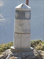 view gallery view galleryS6.1 km |  Grenzsäule 147, Bayern, Tirol, Vorarlberg Grenzsäule 147, Bayern, Tirol, Vorarlberg
in Exact Replicas Der Grenzstein 147 markiert den Dreiländerpunkt, in dem sich die Bundesländer Bayern, Tirol und Vorarlberg treffen *** The boundary pole 147 marks the border triangle of the three federal states Bavaria, Tyrol and Vorarlberg in Germany or Austria. posted by: 4spring location: Bayern, Germany date approved: 02/25/2018 last visited: 10/19/2017 |
 view gallery view galleryS6.1 km |  Grenzsäule 147, Bayern, Tirol, Vorarlberg Grenzsäule 147, Bayern, Tirol, Vorarlberg
in Public Land Survey Marks Der Grenzstein 147 markiert den Dreiländerpunkt, in dem sich die Bundesländer Bayern, Tirol und Vorarlberg treffen *** The boundary pole 147 marks the border triangle of the three federal states Bavaria, Tyrol and Vorarlberg in Germany or Austria. posted by: 4spring location: Bayern, Germany date approved: 11/25/2017 last visited: 10/19/2017 |
 view gallery view galleryS6.1 km |  Rappenalptal, Oberstdorf, Germany Rappenalptal, Oberstdorf, Germany
in Public Access Lands Am Anfang des Rappenalptals steht der Grenzstein 147 und es endet in Einödsbach *** This Valley starts at the boundary stone # 147 and ends in the small town Einödsbach posted by: 4spring location: Bayern, Germany date approved: 03/02/2018 last visited: 03/10/2018 |
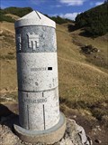 view gallery view galleryS6.1 km | Grenzstein 147, Warth, Austria in Lucky 7 Der Grenzstein 147 markiert den Dreiländerpunkt, in dem sich die Bundesländer Bayern, Tirol und Vorarlberg treffen *** The boundary pole 147 marks the border triangle of the three federal states Bavaria, Tyrol and Vorarlberg in Germany or Austria. posted by: 4spring location: Vorarlberg, Austria date approved: 03/02/2018 last visited: 10/19/2017 |
 view gallery view galleryS6.1 km | Grenzstein 147, Warth, Austria in Scenic Overlooks Der Grenzstein 147 markiert den Dreiländerpunkt, in dem sich die Bundesländer Bayern, Tirol und Vorarlberg treffen *** The boundary pole 147 marks the border triangle of the three federal states Bavaria, Tyrol and Vorarlberg in Germany or Austria. posted by: 4spring location: Vorarlberg, Austria date approved: 02/26/2018 last visited: 10/19/2017 |
|