 view gallery view gallery N1.4 km N1.4 km
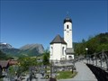
|   Pfarrkirche hll. Philippus und Jakobus - Schoppernau, Vorarlberg Pfarrkirche hll. Philippus und Jakobus - Schoppernau, Vorarlberg
in This Old Church The parish church of Sts. Philip and James is a Roman Catholic church in Schoppernau in the Bregenz Forest. posted by:  SMacB SMacB location: Vorarlberg, Austria date approved: 05/26/2014 last visited: never |
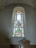 view gallery view galleryN1.4 km |  Stained Glass Windows, Sts. Philip and James - Schoppernau, Vorarlberg Stained Glass Windows, Sts. Philip and James - Schoppernau, Vorarlberg
in Stained Glass Windows The parish church of Sts. Philip and James is a Roman Catholic church in Schoppernau in the Bregenz Forest. posted by: SMacB location: Vorarlberg, Austria date approved: 05/27/2014 last visited: never |
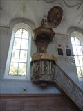 view gallery view galleryN1.4 km |  Pulpit, Sts. Philip and James - Schoppernau, Vorarlberg Pulpit, Sts. Philip and James - Schoppernau, Vorarlberg
in Stone Church Artefacts The parish church of Sts. Philip and James is a Roman Catholic church in Schoppernau in the Bregenz Forest. posted by: SMacB location: Vorarlberg, Austria date approved: 05/29/2014 last visited: never |
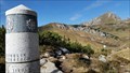
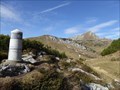
 view gallery view galleryN5.1 km |  Webcam Diedamskopf, Vorarlberg - Austria Webcam Diedamskopf, Vorarlberg - Austria
in Web Cameras Webcam für persönliche Fotos auf der Gipfelstation des Diedamskopfes.
Webcam for personal photos on the summit station of the Diedamskopf. posted by: jotheonly location: Vorarlberg, Austria date approved: 02/05/2016 last visited: 05/02/2016 |
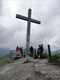
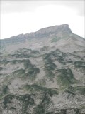
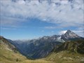
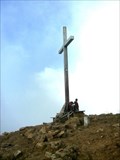 view gallery view galleryN5.1 km |  Diedamskopf, Vorarlberg - Austria Diedamskopf, Vorarlberg - Austria
in Mountain Summits Diedamskopf in Vorarlberg - Österreich posted by: jotheonly location: Vorarlberg, Austria date approved: 01/31/2016 last visited: 01/31/2016 |
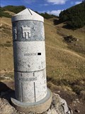
 view gallery view gallery E8.9 km E8.9 km
|  3 Steinmänner - Walmendinger Horn, Mittelberg, Austria, Vorarlberg 3 Steinmänner - Walmendinger Horn, Mittelberg, Austria, Vorarlberg
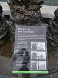
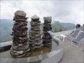
in Rock and Mineral Displays At the mountain station of the aerial lift to the summit of the Walmendinger Horn is a small fountain which sets some rocks on a permanent display. posted by:  Tante.Hossi Tante.Hossi location: Vorarlberg, Austria date approved: 08/30/2013 last visited: 08/13/2014 |
 view gallery view galleryE8.9 km |  Drei Steinmänner, Summit of Walmendinger Horn, Austria, Vorarlberg Drei Steinmänner, Summit of Walmendinger Horn, Austria, Vorarlberg
in Cairns At the mountain station of the aerial lift to the summit of the Walmendinger Horn nearby to Mittelberg, Austria, Vorarlberg, is a fountain located which includes three Cairns. posted by: Tante.Hossi location: Vorarlberg, Austria date approved: 08/26/2013 last visited: 08/13/2014 |
 view gallery view galleryE8.9 km |  Drei Steinmännerbrunnen - Walmendinger Horn - Austria, Vorarlberg Drei Steinmännerbrunnen - Walmendinger Horn - Austria, Vorarlberg
in Fountains This fountain is called 'Drei Steinmännerbrunnen' (Fountain of three stone men). It is located at the mountain station of the 'Walmendingerhornbahn' an arial lift to the summit of the Walmendinger Horn nearby to Mittelberg, Austria, Vorarlberg. posted by: Tante.Hossi location: Vorarlberg, Austria date approved: 08/26/2013 last visited: 08/13/2014 |
 view gallery view galleryE8.9 km | Walmendinger Horn (1990m) - Austria, Vorarlberg in Mountain Summits The so-called 'Walmendinger Horn' is a mountain in Vorarlberg, Austria. It's elevation is 1990 m (6528 feet). it is accessable by an aerial lift from Mittelberg in the Kleinwalsertal. posted by: Tante.Hossi location: Vorarlberg, Austria date approved: 08/23/2013 last visited: 08/07/2014 |
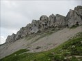
 view gallery view gallery NE10.1 km NE10.1 km
|  Gottesacker, Oberstdorf, Lk Oberallgäu Gottesacker, Oberstdorf, Lk Oberallgäu
in Wikipedia Entries Karstlandschaft "Gottesackerplateau" im Allgäu.
---
Karst landscape "Gottesackerplateau", Allgäu. posted by: lumbricus location: Bayern, Germany date approved: 08/19/2011 last visited: 02/25/2014 |
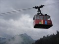 view gallery view galleryE10.6 km |  Walmendingerhornbahn - Mittelberg, Austria, Vorarlberg Walmendingerhornbahn - Mittelberg, Austria, Vorarlberg
in Aerial Lifts The so-called 'Walmendingerhornbahn' is an aerial lift located at the 'Walmendingerhorn' a mountain in the alps in Austria, Vorarlberg. It is accessable from Mittelberg in the 'Kleinwalsertal'. posted by: Tante.Hossi location: Vorarlberg, Austria date approved: 08/23/2013 last visited: 08/13/2014 |
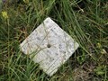
 view gallery view galleryNE11.4 km |  Gottesacker Scharte, 1967m, Oberstdorf, Lk Oberallgäu Gottesacker Scharte, 1967m, Oberstdorf, Lk Oberallgäu
in Elevation Signs Schild an der Gottesacker Scharte bei 1967m.
---
Sign at the Gottesacker Scharte (6453feet). posted by: lumbricus location: Bayern, Germany date approved: 07/28/2011 last visited: never |
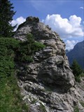
 view gallery view galleryNE11.4 km |  TP Torkopfscharte, Gottesacker, Oberstdorf, Bayern TP Torkopfscharte, Gottesacker, Oberstdorf, Bayern
in German Trigonometric Points Der TP liegt bei der Torkopfscharte mit Blick über den Gottesacker.
---
This German Trigpoint is located at the Torkopfscharte near the Gottesackerplateau. posted by: lumbricus location: Bayern, Germany date approved: 07/27/2011 last visited: never |
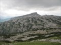 view gallery view galleryNE11.6 km |  Obere Gottesackerwände, Oberstdorf, Lk Oberallgäu Obere Gottesackerwände, Oberstdorf, Lk Oberallgäu
in Scenic Overlooks Ausblick von den "Oberen Gottesackerwände".
---
Great view from the top of the "Oberen Gottesackerwände". posted by: lumbricus location: Bayern, Germany date approved: 07/28/2011 last visited: 02/25/2014 |
 view gallery view galleryNE11.9 km | Obere Gottesackerwände, Oberstdorf, Lk Oberallgäu in Wikipedia Entries "Obere Gottesackerwände" im Allgäu. --- "Oberen Gottesackerwände" in Allgäu. posted by: lumbricus location: Bayern, Germany date approved: 08/19/2011 last visited: 02/25/2014 |
 view gallery view gallery SE12.1 km SE12.1 km
|  Gipslöcher Nature Preserve - Lechtal Gipslöcher Nature Preserve - Lechtal
in Places of Geologic Significance The Gipslöcher or "Gypsum holes" are a geological formation of deep holes in a soft Gypsum rock layer near the alpine resort town of Lech. It is a Nature Preserve and has several species of orchid and other special flora. posted by: RakeInTheCache location: Vorarlberg, Austria date approved: 01/14/2007 last visited: 07/26/2023 |
 view gallery view galleryE12.2 km | Haldenwanger Eck, Oberstdorf, Lk Oberallgäu, Germany in Scenic Overlooks Haldenwanger Eck nahe dem südlichsten Punkt Deutschlands.
---
Haldenwanger Eck near the southest point of germany. posted by: lumbricus location: Bayern, Germany date approved: 07/28/2011 last visited: 10/19/2017 |
 view gallery view gallery NW12.7 km NW12.7 km
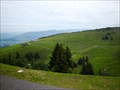
| Panorama-Wanderweg Andelsbuch-Niedere - Bezau, Vorarlberg, Austria in Scenic Hikes Panorama-Wanderweg Andelsbuch-Niedere - Bezau, Vorarlberg, Austria posted by: luzzi-reloaded location: Vorarlberg, Austria date approved: 10/14/2011 last visited: 07/06/2013 |
 view gallery view galleryE12.7 km | Grenzstein 147, Warth, Austria in Scenic Hikes Der Grenzstein 147 markiert den Dreiländerpunkt, in dem sich die Bundesländer Bayern, Tirol und Vorarlberg treffen *** The boundary pole 147 marks the border triangle of the three federal states Bavaria, Tyrol and Vorarlberg in Germany or Austria. posted by: 4spring location: Vorarlberg, Austria date approved: 02/28/2018 last visited: 10/19/2017 |
 view gallery view galleryE12.7 km |  Grenzsäule 147, Bayern, Tirol, Vorarlberg Grenzsäule 147, Bayern, Tirol, Vorarlberg
in Border Crossings Der Grenzstein 147 markiert den Dreiländerpunkt, in dem sich die Bundesländer Bayern, Tirol und Vorarlberg treffen *** The boundary pole 147 marks the border triangle of the three federal states Bavaria, Tyrol and Vorarlberg in Germany or Austria. posted by: 4spring location: Vorarlberg, Austria date approved: 01/18/2018 last visited: 10/19/2017 |
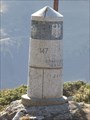 view gallery view galleryE12.7 km |  Grenzsäule 147, Bayern, Tirol, Vorarlberg Grenzsäule 147, Bayern, Tirol, Vorarlberg
in Exact Replicas Der Grenzstein 147 markiert den Dreiländerpunkt, in dem sich die Bundesländer Bayern, Tirol und Vorarlberg treffen *** The boundary pole 147 marks the border triangle of the three federal states Bavaria, Tyrol and Vorarlberg in Germany or Austria. posted by: 4spring location: Bayern, Germany date approved: 02/25/2018 last visited: 10/19/2017 |
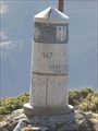 view gallery view galleryE12.7 km |  Grenzsäule 147, Bayern, Tirol, Vorarlberg Grenzsäule 147, Bayern, Tirol, Vorarlberg
in Public Land Survey Marks Der Grenzstein 147 markiert den Dreiländerpunkt, in dem sich die Bundesländer Bayern, Tirol und Vorarlberg treffen *** The boundary pole 147 marks the border triangle of the three federal states Bavaria, Tyrol and Vorarlberg in Germany or Austria. posted by: 4spring location: Bayern, Germany date approved: 11/25/2017 last visited: 10/19/2017 |
 view gallery view galleryE12.7 km |  Rappenalptal, Oberstdorf, Germany Rappenalptal, Oberstdorf, Germany
in Public Access Lands Am Anfang des Rappenalptals steht der Grenzstein 147 und es endet in Einödsbach *** This Valley starts at the boundary stone # 147 and ends in the small town Einödsbach posted by: 4spring location: Bayern, Germany date approved: 03/02/2018 last visited: 03/10/2018 |
 view gallery view galleryE12.7 km |  Grenzstein 147, Bayern, Tirol, Vorarlberg Grenzstein 147, Bayern, Tirol, Vorarlberg
in Tripoints and Multipoints Der Grenzstein 147 markiert den Dreiländerpunkt, in dem sich die Bundesländer Bayern, Tirol und Vorarlberg treffen *** The boundary stone 147 marks the border triangle of the three federal states Bavaria, Tyrol and Vorarlberg. posted by: 4spring location: Vorarlberg, Austria date approved: 10/31/2017 last visited: 10/19/2017 |
 view gallery view galleryE12.7 km |  Grenzstein 147, Warth, Austria Grenzstein 147, Warth, Austria
in Lucky 7 Der Grenzstein 147 markiert den Dreiländerpunkt, in dem sich die Bundesländer Bayern, Tirol und Vorarlberg treffen *** The boundary pole 147 marks the border triangle of the three federal states Bavaria, Tyrol and Vorarlberg in Germany or Austria. posted by: 4spring location: Vorarlberg, Austria date approved: 03/02/2018 last visited: 10/19/2017 |
|