 view gallery view gallery W10.5 km W10.5 km
|   Hilger GTA Farmers Un Elev - Hilger, MT Hilger GTA Farmers Un Elev - Hilger, MT
in U.S. Benchmarks Across Highway 191 from the little village of Hilger stands its only grain elevator. It appears that this was the only elevator ever to be built at Hilger. posted by:  T0SHEA T0SHEA location: Montana date approved: 09/03/2017 last visited: never |
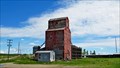 view gallery view galleryW10.5 km |  Hilger GTA Farmers Union Elevator - Hilger, Montana Hilger GTA Farmers Union Elevator - Hilger, Montana
in Grain Elevators Across Highway 191 from the little village of Hilger stands its only grain elevator. It appears that this was the only elevator ever to be built at Hilger. posted by: T0SHEA location: Montana date approved: 09/20/2017 last visited: never |
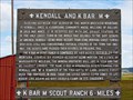 view gallery view galleryW10.5 km |  Kendall and K Bar M - Hilger, MT Kendall and K Bar M - Hilger, MT
in Montana Historical Markers At the little town og Hilger, this Montana Historical Highway Marker is at the junction of Winifred and Kendall Roads, just north off Highway 191. posted by: T0SHEA location: Montana date approved: 08/06/2017 last visited: never |
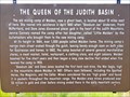 view gallery view gallery SW15.1 km SW15.1 km
| The Queen of the Judith Basin - Lewistown, MT in Montana Historical Markers Along Highway 191 about nine miles north of Lewiston, at a crossroad named Maiden Road, named for the old mining camp, one will find this Montana Historical Highway Marker at a pullout on the east side of the highway posted by: T0SHEA location: Montana date approved: 08/06/2017 last visited: never |
 view gallery view gallerySW19.8 km |  Central Montana Memorial Gardens - Lewistown, Montana Central Montana Memorial Gardens - Lewistown, Montana
in Worldwide Cemeteries Central Montana Memorial Gardens is north of Lewistown about 10 km on Hwy. 191. posted by: T0SHEA location: Montana date approved: 02/03/2018 last visited: never |
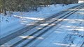
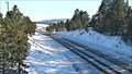
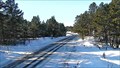 view gallery view gallery S20.9 km S20.9 km
|  Lewistown Divide West Pullout Camera - Lewiston, MT Lewistown Divide West Pullout Camera - Lewiston, MT
in Web Cameras This is one of 73 (as of January 2017) Road Weather Information System camera sites operated by the Montana Department of Transportation to aid motorists as they make their way across BIG SKY Country. posted by: T0SHEA location: Montana date approved: 01/30/2017 last visited: never |
 view gallery view galleryS20.9 km | Lewistown Divide Roadway Camera - Lewiston, MT in Web Cameras This is one of 73 (as of January 2017) Road Weather Information System camera sites operated by the Montana Department of Transportation to aid motorists as they make their way across BIG SKY Country. posted by: T0SHEA location: Montana date approved: 01/30/2017 last visited: never |
 view gallery view galleryS20.9 km | Lewistown Divide East Camera - Lewiston, MT in Web Cameras This is one of 73 (as of January 2017) Road Weather Information System camera sites operated by the Montana Department of Transportation to aid motorists as they make their way across BIG SKY Country. posted by: T0SHEA location: Montana date approved: 01/30/2017 last visited: never |
 view gallery view galleryS20.9 km | Lewistown Divide East S Curve Camera - Lewiston, MT in Web Cameras This is one of 73 (as of January 2017) Road Weather Information System camera sites operated by the Montana Department of Transportation to aid motorists as they make their way across BIG SKY Country. posted by: T0SHEA location: Montana date approved: 01/30/2017 last visited: never |
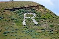 view gallery view gallery E21.4 km E21.4 km
|  R is for Roy, Montana R is for Roy, Montana
in Letters on Hills The little village of Roy advertises itself with an "R" on a bluff south of town, barely discernible from Highway 191 which passes immediately north of the town. posted by: T0SHEA location: Montana date approved: 05/17/2019 last visited: never |
 view gallery view galleryE21.4 km |  Roy, Montana - 59471 Roy, Montana - 59471
in U.S. Post Offices The Milwaukee Railroad Company was the one responsible for the existence of the town of Roy, Montana. posted by: T0SHEA location: Montana date approved: 06/15/2019 last visited: never |
 view gallery view galleryE21.4 km |  Roy, Montana Roy, Montana
in Wikipedia Entries The Milwaukee Railroad Company was the one responsible for the existence of the town of Roy. posted by: T0SHEA location: Montana date approved: 05/19/2019 last visited: never |
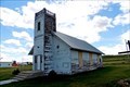 view gallery view galleryE21.4 km |  Former Roy First English Lutheran Church - Roy, MT Former Roy First English Lutheran Church - Roy, MT
in Bell Towers This small town church began life in 1916 as a Lutheran church. posted by: T0SHEA location: Montana date approved: 05/17/2019 last visited: never |
 view gallery view galleryE21.4 km |  Former Roy Presbyterian Church - Roy, MT Former Roy Presbyterian Church - Roy, MT
in Presbyterian Churches This small town church began life in 1916 as a Lutheran church. posted by: T0SHEA location: Montana date approved: 05/17/2019 last visited: never |
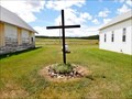 view gallery view galleryE21.4 km |  Roy Community Church Cross - Roy, MT Roy Community Church Cross - Roy, MT
in Churchyard Crosses This cross stands between two former Presbyterian churches, one of which is now a community church, posted by: T0SHEA location: Montana date approved: 05/17/2019 last visited: never |
 view gallery view galleryE21.4 km |  Former Roy First English Lutheran Church - Roy, MT Former Roy First English Lutheran Church - Roy, MT
in Lutheran Churches This small town church began life in 1916 as a Lutheran church. posted by: T0SHEA location: Montana date approved: 05/19/2019 last visited: never |
 view gallery view galleryE21.4 km | Former Roy First English Lutheran Church - Roy, MT in This Old Church This small town church began life in 1916 as a Lutheran church. posted by: T0SHEA location: Montana date approved: 05/24/2019 last visited: never |
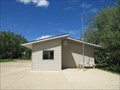
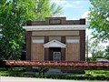 view gallery view galleryE21.4 km |  Roy Will Have a Second Bank Roy Will Have a Second Bank
in News Article Locations Roy's second bank, the Security State Bank building, stands on the east side of Main Street, one lot north of 2nd Avenue, across from the post office. posted by: T0SHEA location: Montana date approved: 05/19/2019 last visited: never |
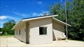
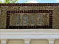 view gallery view galleryE21.4 km |  1917 - Former Security State Bank - Roy, MT 1917 - Former Security State Bank - Roy, MT
in Dated Buildings and Cornerstones Roy's second bank, the Security State Bank building, stands on the east side of Main Street, one lot north of 2nd Avenue, across from the post office. posted by: T0SHEA location: Montana date approved: 05/17/2019 last visited: never |
 view gallery view galleryE21.4 km |  Former Security State Bank - Roy, MT Former Security State Bank - Roy, MT
in Converted Bank Buildings Roy's second bank, the Security State Bank building, stands on the east side of Main Street, one lot north of 2nd Avenue, across from the post office. posted by: T0SHEA location: Montana date approved: 05/17/2019 last visited: never |
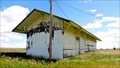 view gallery view galleryE21.6 km |  Roy Depot - Roy, MT Roy Depot - Roy, MT
in Train Stations/Depots A little railway depot in an even littler town, the Roy Depot has been abandoned for some time now. posted by: T0SHEA location: Montana date approved: 05/16/2019 last visited: never |
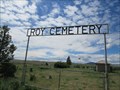 view gallery view gallery NE21.9 km NE21.9 km
| Roy Cemetery - Roy, Montana in Worldwide Cemeteries Roy Cemetery is just a short distance north of Hwy. 191 on Main Street, turn east at the "Y". posted by: T0SHEA location: Montana date approved: 01/28/2018 last visited: never |
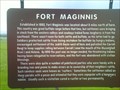 view gallery view galleryS23.7 km | Fort Maginnis Historical Marker in Montana Historical Markers Ever so popular red sign found on the side of a highway to explain the historical importance of the area you are traveling in. This one notes the existence of an old fort, and the introduction of cattle in the area near Grass Ridge, Montana. posted by: Topper-Tsennya location: Montana date approved: 06/21/2010 last visited: 07/18/2022 |
 view gallery view gallerySW25.7 km |  Monarch Range - Lewistown MT Monarch Range - Lewistown MT
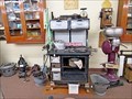
in Household Appliances and Presses At the far northeastern corner of Lewistown, the Central Montana Museum is one of the larger museums in this part of the state. Their collection includes many examples of household appliances, implements and other apparati. posted by: T0SHEA location: Montana date approved: 03/21/2019 last visited: never |
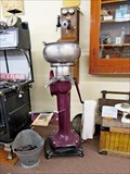 view gallery view gallerySW25.7 km | McCormick Deering Cream Separator - Lewistown MT in Household Appliances and Presses At the far northeastern corner of Lewistown, the Central Montana Museum is one of the larger museums in this part of the state. Their collection includes many examples of household appliances, implements and other apparati. posted by: T0SHEA location: Montana date approved: 03/21/2019 last visited: never |
|