 view gallery view gallery NW45.5 km NW45.5 km
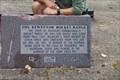
|   The Keweenaw Rocket Range The Keweenaw Rocket Range
in Military Installations The Keweenaw Rocket Range was a joint Air Force and NASA-operated base for launching sounding rockets between 1962 and 1971. posted by:  kJfishman kJfishman location: Michigan date approved: 12/26/2007 last visited: 08/28/2010 |
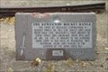 view gallery view galleryNW45.5 km |  The Keweenaw Rocket Range - Copper Harbor MI The Keweenaw Rocket Range - Copper Harbor MI
in Best Kept Secrets The Keweenaw Rocket Range - Copper Harbor MI posted by: kJfishman location: Michigan date approved: 01/21/2016 last visited: never |
 view gallery view gallery SW51 km SW51 km
|  Big Bay MI Anatomy of a Murder - 1959 Big Bay MI Anatomy of a Murder - 1959
in Movie Locations Big Bay MI Anatomy of a Murder - 1959 Big Bay Inn (Thunder Bay Inn) posted by: kJfishman location: Michigan date approved: 08/21/2009 last visited: 08/21/2009 |
 view gallery view gallerySW51 km |  Big Bay Point Lighthouse Bed & Breakfast - Big Bay MI Big Bay Point Lighthouse Bed & Breakfast - Big Bay MI
in Lighthouse Bed and Breakfasts Big Bay Point Lighthouse Bed 7 Breakfast - Big Bay MI posted by: kJfishman location: Michigan date approved: 08/06/2008 last visited: 12/13/2019 |
 view gallery view gallerySW51 km |  Big Bay Point Lighthouse - Big Bay MI Big Bay Point Lighthouse - Big Bay MI
in Coastal Lighthouses Big Bay Point Lighthouse - Big Bay MI posted by: kJfishman location: Michigan date approved: 08/05/2008 last visited: 09/20/2016 |
 view gallery view gallerySW51 km |  Big Bay Point Lighthouse - Big Bay MI Big Bay Point Lighthouse - Big Bay MI
in Official Local Tourism Attractions Big Bay Point Lighthouse posted by: kJfishman location: Michigan date approved: 08/20/2011 last visited: 12/13/2019 |
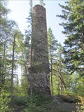 view gallery view galleryNW55.5 km |  Clark Mine Chimney - Copper Harbor, MI Clark Mine Chimney - Copper Harbor, MI
in Lonely Chimneys This lonely chimney is all that remains from one of the early copper mines of the Keweenaw Peninsula. posted by:  linkys linkys location: Michigan date approved: 09/17/2011 last visited: 08/19/2018 |
 view gallery view galleryNW55.5 km |  Clark Mine - Copper Harbor, MI Clark Mine - Copper Harbor, MI
in Mines An abandoned copper mine in Copper Harbor that unfortunately had very little copper. posted by: linkys location: Michigan date approved: 09/16/2011 last visited: 08/19/2018 |
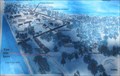
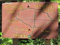 view gallery view galleryNW56.2 km |  Memorial Grove - You Are Here Map - Copper Harbor, MI Memorial Grove - You Are Here Map - Copper Harbor, MI
in 'You Are Here' Maps You Are Here map on a somewhat confusing set of trails in the oldest stand of white pines in Michigan. posted by: linkys location: Michigan date approved: 09/17/2011 last visited: 08/19/2018 |
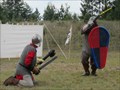 view gallery view gallerySW56.5 km |  Ishpeming Renaissance Festival -Ishpeming, MI Ishpeming Renaissance Festival -Ishpeming, MI
in Renaissance Fairs Annual Renaissance Fair held in a small Upper Peninsula town. posted by: linkys location: Michigan date approved: 08/13/2011 last visited: never |
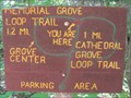 view gallery view galleryNW56.5 km | Top of the Trail - You Are Here Map - Copper Harbor, MI in 'You Are Here' Maps You Are Here map on a somewhat confusing set of trails in the oldest stand of white pines in Michigan. posted by: linkys location: Michigan date approved: 09/17/2011 last visited: never |
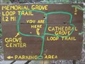 view gallery view galleryNW56.5 km | Memorial Grove- You Are Here - Copper Harbor, MI in 'You Are Here' Maps You Are Here map on a somewhat confusing set of trails in the oldest stand of white pines in Michigan. posted by: linkys location: Michigan date approved: 09/17/2011 last visited: never |
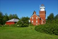
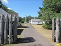
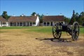 view gallery view galleryNW56.5 km |  Ft. Wilkins - Copper Harbor MI Ft. Wilkins - Copper Harbor MI
in Historic Forts Fort Wilkins Historic State Park, in the northern Keweenaw Peninsula, offers camping and day use facilities and features a restored 1844 army military outpost and one of the first lighthouses on Lake Superior built in 1866. Fort Wilkins became a State Park in 1923. Extensive restoration work and development began in the 1930s under the Work Project Administration. posted by: kJfishman location: Michigan date approved: 12/12/2007 last visited: 02/17/2012 |
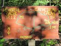 view gallery view galleryNW56.6 km | Cathederal Grove - You Are Here - Copper Harbor, MI in 'You Are Here' Maps You Are Here map on a somewhat confusing set of trails in the oldest stand of white pines in Michigan. posted by: linkys location: Michigan date approved: 09/17/2011 last visited: never |
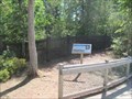
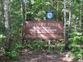 view gallery view galleryNW56.6 km |  Estivant Pines Trailhead - Copper Harbor, MI Estivant Pines Trailhead - Copper Harbor, MI
in Hiking and walking trailheads Double loop trail through the oldest stand of white pines in Michigan. posted by: linkys location: Michigan date approved: 09/18/2011 last visited: 08/19/2018 |
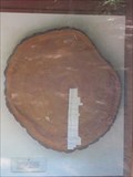 view gallery view galleryNW56.6 km |  White Pine - Estivant Pines Nature Sanctuary - Copper Harbor, MI White Pine - Estivant Pines Nature Sanctuary - Copper Harbor, MI
in Exceptional Tree Growth Ring Displays Tree cookie at the trail head to an old growth white pine sancturary that was saved from logging in the early 1970's. posted by: linkys location: Michigan date approved: 10/02/2011 last visited: 08/19/2018 |
 view gallery view galleryNW56.6 km |  Estivant Pines Nature Sanctuary - Copper Harbor, MI Estivant Pines Nature Sanctuary - Copper Harbor, MI
in Public Access Lands The Estivant Pines Nature Sanctuary is home to the oldest stands of virgin white pine forest in Michigan. posted by: linkys location: Michigan date approved: 09/18/2011 last visited: 08/19/2018 |
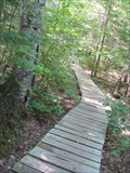 view gallery view galleryNW56.6 km |  Estivant Pines Nature Sanctuary Boardwalk - Copper Harbor, MI Estivant Pines Nature Sanctuary Boardwalk - Copper Harbor, MI
in Non-Coastal Boardwalks Boardwalk on an uphill section of the trail through the oldest stand of white pines in Michigan. posted by: linkys location: Michigan date approved: 09/18/2011 last visited: 08/19/2018 |
 view gallery view galleryNW57 km | Fort Wilkins Mine - Copper Harbor, MI in Mines One of the earliest copper mines in what became known as the Michigan Copper Country. posted by: linkys location: Michigan date approved: 09/16/2011 last visited: 12/20/2012 |
 view gallery view galleryNW57 km | History Comes Alive - You Are Here - Copper Harbor, MI in 'You Are Here' Maps Nicely done You Are Here Map on the path leading to gates of Fort Wilkins. posted by: linkys location: Michigan date approved: 09/17/2011 last visited: 08/19/2018 |
 view gallery view galleryNW57 km |  Fort Wilkins - Copper Harbor, MI Fort Wilkins - Copper Harbor, MI
in U.S. National Register of Historic Places Historic U.S. military fort located in the Michigan Copper Country. posted by: linkys location: Michigan date approved: 09/16/2011 last visited: 05/04/2016 |
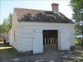 view gallery view galleryNW57 km |  Fort Wilkins Balcksmith Shop - Copper Harbor, MI Fort Wilkins Balcksmith Shop - Copper Harbor, MI
in Blacksmith Shops Early Military Fort blacksmith shop reconstructed on the site of the original. posted by: linkys location: Michigan date approved: 09/16/2011 last visited: 08/19/2018 |
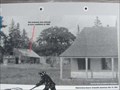 view gallery view galleryNW57.1 km |  Fort Wilkins Ice House - Copper Harbor, MI Fort Wilkins Ice House - Copper Harbor, MI
in Photos Then and Now Fort Wilkins, abandoned in the late 1860's had stood vacant for mant years when this photo was taken in 1889. posted by: linkys location: Michigan date approved: 09/16/2011 last visited: 08/19/2018 |
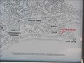 view gallery view galleryNW57.1 km | Hays' Point - You Are Here Map - Copper Harbor, MI in 'You Are Here' Maps This was the place in 1840 where the presence of copper on the Keweenaw Peninsula was confirmed by Douglas Houghton. posted by: linkys location: Michigan date approved: 09/19/2011 last visited: never |
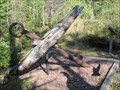 view gallery view galleryNW57.1 km |  Hays' Point Anchor - Copper Harbor, MI Hays' Point Anchor - Copper Harbor, MI
in Anchors Anchor along the path on Hays' Point leading from the boat landing to the Copper Harbor Lighthouse. posted by: linkys location: Michigan date approved: 09/16/2011 last visited: 02/28/2012 |
|