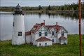
 view gallery view gallery SW8.2 km SW8.2 km
|   Model of Iroquois Point Lighthouse - Bay Mills MI Model of Iroquois Point Lighthouse - Bay Mills MI
in Roadside Attractions Located on West Lakeshore Drive about 2.5 miles from the real McCoy posted by:  nomadwillie nomadwillie location: Michigan date approved: 10/22/2015 last visited: 02/12/2019 |
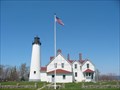 view gallery view gallery W8.9 km W8.9 km
|  Point Iroquois Lighthouse Point Iroquois Lighthouse
in Coastal Lighthouses Point Iroquois Lighthouse is located on Lakeshore Dr. just NW Of Brimley,Mi in the Upper Peninsula. posted by:  Jagman714 Jagman714 location: Michigan date approved: 12/20/2006 last visited: 08/28/2019 |
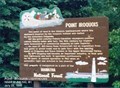 view gallery view galleryW9.3 km |  Point Iroquois - Brimley MI Point Iroquois - Brimley MI
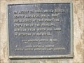
in Michigan Historical Markers This point of land is the historic battleground where the westward invasion by the Iroquois Indians was halted by the victorious Chippewa. Off the point colorful French-Canadian voyageurs paddled canoes heavily laden with furs. posted by: Don.Morfe location: Michigan date approved: 09/20/2020 last visited: 10/23/2021 |
 view gallery view galleryW9.3 km |  Point Iroquois Light Station - Brimley MI Point Iroquois Light Station - Brimley MI
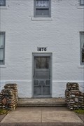
in U.S. National Register of Historic Places Built in 1870 to replace the original lighthouse built. posted by: nomadwillie location: Michigan date approved: 10/22/2015 last visited: 08/28/2019 |
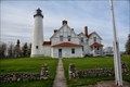 view gallery view galleryW9.3 km |  Point Iroquois Light Station - Brimley MI Point Iroquois Light Station - Brimley MI
in Maritime Museums Built in 1870 to replace the original lighthouse built. Today it is a museum. posted by: nomadwillie location: Michigan date approved: 10/22/2015 last visited: 07/08/2021 |
 view gallery view galleryW9.3 km |  1870 - Point Iroquois Light Station - Brimley MI 1870 - Point Iroquois Light Station - Brimley MI
in Dated Buildings and Cornerstones Built in 1870 to replace the original lighthouse built. posted by: nomadwillie location: Michigan date approved: 10/23/2015 last visited: 08/28/2019 |
 view gallery view gallerySW10 km |  Bay Mills Casino - Brimley, Michigan Bay Mills Casino - Brimley, Michigan
in Casinos Casino located in Brimley, Michigan. posted by: theHostas location: Michigan date approved: 07/28/2018 last visited: 07/10/2018 |
 view gallery view gallery E10.3 km E10.3 km
|  Soo Co-op Credit Union - Sault Ste. Marie, MI Soo Co-op Credit Union - Sault Ste. Marie, MI
in Time and Temperature Signs Time and temperature sign in front of the Soo Co-op Credit Union in Sault Ste. Marie, Michigan. posted by: bobfrapples8 location: Michigan date approved: 01/27/2023 last visited: never |
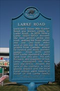 view gallery view galleryE10.6 km | Larke Road in Michigan Historical Markers The Larke Road Marker is located in front of a gas station on Three Mile Rd east of I-75 in Sault Ste. Marie. posted by: Jagman714 location: Michigan date approved: 07/12/2009 last visited: 03/19/2018 |
 view gallery view galleryE11.1 km |  Studebaker - Sault Ste Marie - Michigan. Studebaker - Sault Ste Marie - Michigan.
in Permanent Car Displays Yellow Studebaker. Mounted outside the Studebaker Restaurant, Sault Ste Marie, Michigan, USA. posted by: veritas vita location: Michigan date approved: 06/06/2012 last visited: 08/16/2017 |
 view gallery view galleryE11.1 km |  WAL*MART Supercenter #1936 - Sault Sainte Marie, Michigan WAL*MART Supercenter #1936 - Sault Sainte Marie, Michigan
in WAL*MART Stores Walmart Supercenter in Sault Sainte Marie, Michigan. posted by: theHostas location: Michigan date approved: 07/22/2018 last visited: 06/16/2021 |
 view gallery view galleryE11.3 km | Lake Superior State College in Michigan Historical Markers The Lake Superior State College marker is located on the campus of Lake Superior State University posted by: Jagman714 location: Michigan date approved: 07/12/2009 last visited: 01/05/2023 |
 view gallery view gallery SE11.3 km SE11.3 km
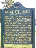
| Sault Ste. Marie in Michigan Historical Markers Sault Ste Marie city marker located at a rest area along I-75 posted by: rj_toot location: Michigan date approved: 09/01/2012 last visited: 03/02/2023 |
 view gallery view galleryE11.3 km |  International Bridge - Sault Ste Marie - Michigan - USA. International Bridge - Sault Ste Marie - Michigan - USA.
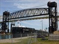
in Moving Bridges A vertical lift railroad bridge, double bascule bridge, and swing bridge, over the St. Marys River between Sault Ste Marie, Michigan, USA and Sault Ste. Marie, Ontario, Canada. posted by: veritas vita location: Michigan date approved: 06/08/2012 last visited: 01/19/2022 |
 view gallery view galleryE11.3 km |  Principal Meridian - Sault Ste. Marie - Michigan, USA. Principal Meridian - Sault Ste. Marie - Michigan, USA.
in U.S. Historic Survey Stones and Monuments A plaque dated August 25, 1840. marking the point from which all land in Michigan is surveyed. Located at Sault Ste. Marie, Upper Peninsula, Michigan. posted by: veritas vita location: Michigan date approved: 01/09/2013 last visited: 12/19/2016 |
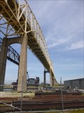
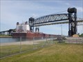 view gallery view galleryE11.3 km |  International Railway Bridge - Sault Ste Marie - Michigan - USA. International Railway Bridge - Sault Ste Marie - Michigan - USA.
in Railroad Bridges A single track, combination series of bridges including a vertical lift railroad bridge, double bascule bridge, and swing bridge, over the St. Marys River and Soo Locks, between Sault Ste Marie, Michigan, USA and Sault Ste. Marie, Ontario, Canada. posted by: veritas vita location: Michigan date approved: 06/08/2012 last visited: 08/09/2020 |
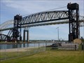 view gallery view galleryE11.3 km | International Bridge - Sault Ste Marie - Michigan - USA. in Vertical Lift Bridges A vertical lift railroad bridge, part of the International Bridge over the St. Marys River between Sault Ste Marie, Michigan, USA and the twin city of Sault Ste. Marie, Ontario, Canada. posted by: veritas vita location: Michigan date approved: 10/16/2012 last visited: 01/19/2022 |
 view gallery view galleryE11.3 km |  Sault Ste Marie - International Bridge - Michigan, USA. Sault Ste Marie - International Bridge - Michigan, USA.
in Wikipedia Entries International border crossing using the I-75 road across the 'International Road Bridge' over St. Marys River and the Soo Locks, between the twin cities of Sault Ste Marie, Michigan, USA and Sault Ste. Marie, Ontario, Canada. posted by: veritas vita location: Michigan date approved: 01/20/2013 last visited: 08/09/2020 |
 view gallery view galleryE11.3 km |  USA to Canada - I-75 - Sault Ste Marie, Michigan. USA to Canada - I-75 - Sault Ste Marie, Michigan.
in Border Crossings International border crossing using the I-75 across the 'International Bridge' over St. Marys River and the Soo Locks, between the twin cities of Sault Ste Marie, Michigan, USA and Sault Ste. Marie, Ontario, Canada. posted by: veritas vita location: Michigan date approved: 06/11/2012 last visited: 08/09/2020 |
 view gallery view galleryE11.3 km |  International Road Bridge - USA/Canada - Sault Ste Marie, Michigan International Road Bridge - USA/Canada - Sault Ste Marie, Michigan
in Satellite Imagery Oddities International border crossing using the I-75 road across the 'International Road Bridge' over St. Marys River and the Soo Locks, between the twin cities of Sault Ste Marie, Michigan, USA and Sault Ste. Marie, Ontario, Canada. posted by: veritas vita location: Michigan date approved: 01/21/2013 last visited: 08/09/2020 |
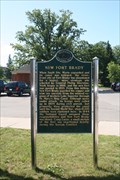 view gallery view galleryE11.4 km | New Fort Brady in Michigan Historical Markers The New Fort Brady Marker is located on the Campus of Lake Superior State University. posted by: Jagman714 location: Michigan date approved: 07/12/2009 last visited: 03/06/2023 |
 view gallery view galleryE11.7 km |  Sault Ste. Marie International Bridge Sault Ste. Marie International Bridge
in Arch Bridges Sault Ste. Marie International Bridge posted by: stagunner location: Ontario, Canada date approved: 08/10/2008 last visited: 03/28/2023 |
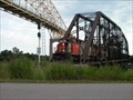 view gallery view galleryE11.9 km |  International Railroad Bridge - Swing Span - Sault Ste. Marie, ON International Railroad Bridge - Swing Span - Sault Ste. Marie, ON
in Truss Bridges Built in 1895 the International Railroad Bridge is still in operation today. posted by: mTn_biKer65 location: Ontario, Canada date approved: 03/23/2013 last visited: 09/09/2022 |
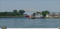
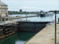
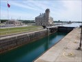 view gallery view galleryE12.2 km |  Soo Locks - Sault Saint Marie - Michigan, USA. Soo Locks - Sault Saint Marie - Michigan, USA.
in Official Local Tourism Attractions Soo locks are a set of parallel locks which enable ships to travel between Lake Superior and the lower Great Lakes. They are located on the St. Marys River between the Upper Peninsula of the US state of Michigan and the Canadian province of Ontario. posted by: veritas vita location: Michigan date approved: 09/10/2012 last visited: 07/11/2018 |
 view gallery view galleryE12.2 km | Largest Lock in the USA - Sault Saint Marie - Michigan. in Satellite Imagery Oddities Soo locks are a set of parallel locks which enable ships to travel between Lake Superior and the lower Great Lakes. They are located on the St. Marys River between the Upper Peninsula of the US state of Michigan and the Canadian province of Ontario. posted by: veritas vita location: Michigan date approved: 01/22/2013 last visited: 06/30/2019 |
|