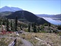
 view gallery view gallery NE0 km NE0 km
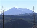
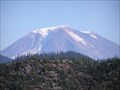
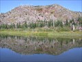
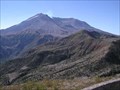
|   Mt. Adams Mt. Adams
in Mountain Summits This is a very majestic peak and fun to climb posted by:  E4han E4han location: Washington date approved: 07/02/2008 last visited: 10/21/2021 |
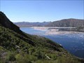
 view gallery view gallery S39.3 km S39.3 km
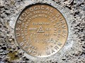
|  16WF1955 - Klickitat County, WA 16WF1955 - Klickitat County, WA
in U.S. Benchmarks In front of the Logs Inn Pub and lodge posted by: Team 11E location: Washington date approved: 03/08/2018 last visited: never |
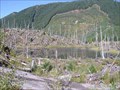
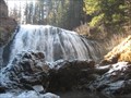 view gallery view galleryNE39.6 km |  south fork falls south fork falls
in Waterfalls wow a short wide falls where you can stand at the base and fel the mist posted by: habanero location: Washington date approved: 10/28/2007 last visited: 06/21/2008 |
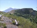
 view gallery view gallery NW40.4 km NW40.4 km
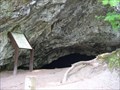
| ") Layser Cave, WA Layser Cave, WA
in Cave Entrances (Natural) An easily accessible cave formerly used by Native American Indians. posted by:  The TriVans The TriVans location: Washington date approved: 07/18/2007 last visited: 08/31/2008 |
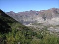
 view gallery view gallery W43.8 km W43.8 km
|  Bear Meadow View Point, Washington Bear Meadow View Point, Washington
in Scenic Roadside Look-Outs The Bear Meadow View Point is located along FS. Rd. 99 east of Mt. St. Helens National Volcanic Monument. posted by: Volcanoguy location: Washington date approved: 11/14/2006 last visited: 11/14/2006 |
 view gallery view galleryW44.4 km | Blast Edge View Point, Washington in Scenic Roadside Look-Outs The Blast Edge View Point is located along FS. Rd. 99 in Mt. St. Helens National Volcanic Monument. posted by: Volcanoguy location: Washington date approved: 11/14/2006 last visited: 12/29/2022 |
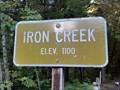 view gallery view galleryNW45.1 km |  Iron Creek - Randle, WA - 1100' Iron Creek - Randle, WA - 1100'
in Elevation Signs Along Forest Road 76 south of Randle, Washington. posted by: WR7X location: Washington date approved: 10/04/2020 last visited: never |
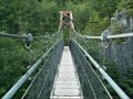 view gallery view galleryW45.7 km |  Lava Canyon Suspension Bridge Lava Canyon Suspension Bridge
in Pedestrian Suspension Bridges Suspended over Muddy River, Lava Canyon Park, Mt. Saint Helens area. posted by: Ambrosia location: Washington date approved: 04/08/2006 last visited: 08/30/2008 |
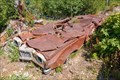 view gallery view galleryW46.2 km |  Miner's Car - Mount St. Helens National Volcanic Monument, Washington, United States Miner's Car - Mount St. Helens National Volcanic Monument, Washington, United States
in Permanent Car Displays The Miner's Car is a remnant of the eruption of Mount St. Helens, on display in the Miner's Car Interpretive Site on the side of Forest Road 99 in Mount St. Helens National Volcanic Monument. posted by: The A-Team location: Washington date approved: 09/12/2022 last visited: never |
 view gallery view galleryW46.2 km | Cascades View Point, Washington in Scenic Roadside Look-Outs The Cascades View Point is located along FS. Rd. 99 in Mt. St. Helens National Volcanic Monument. posted by: Volcanoguy location: Washington date approved: 11/13/2006 last visited: 12/29/2022 |
 view gallery view galleryW46.5 km |  Meta Lake View Point - Washington Meta Lake View Point - Washington
in Scenic Overlooks This view point is reached by a trail from a parking lot on F.S. Rd. 99 at Mt. St. Helens National Volcanic Monument. posted by: Volcanoguy location: Washington date approved: 11/13/2006 last visited: 11/13/2006 |
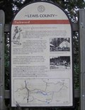 view gallery view gallery N47 km N47 km
|  Packwood Packwood
in Washington Historical Markers This sign is along U.S. Hwy. 12 in Packwood. posted by: Volcanoguy location: Washington date approved: 11/23/2006 last visited: 10/25/2015 |
 view gallery view galleryW47.2 km | Ryan Lake View Point, Washington in Scenic Roadside Look-Outs The Ryan Lake View Point is located along FS. Rd. 25 north of Mt. St. Helens National Volcanic Monument. posted by: Volcanoguy location: Washington date approved: 11/14/2006 last visited: 11/14/2006 |
 view gallery view galleryN47.2 km |  Packwood, WA, 98361 Packwood, WA, 98361
in U.S. Post Offices The Packwood Post Office. posted by: Volcanoguy location: Washington date approved: 11/01/2006 last visited: 12/29/2022 |
 view gallery view galleryN47.2 km |  Blanton’s Market Penny Smasher Blanton’s Market Penny Smasher
in Penny Smashers Penny Smasher in entrance to Blanton’s Market in Packwood, Washington. posted by: Volcanoguy location: Washington date approved: 11/19/2006 last visited: 06/14/2013 |
 view gallery view galleryW47.5 km | Independence Pass View Point - Washington in Scenic Overlooks This view point is reached by a trail from a parking lot on F.S. Rd. 99 at Mt. St. Helens National Volcanic Monument. posted by: Volcanoguy location: Washington date approved: 11/13/2006 last visited: 11/13/2006 |
 view gallery view galleryW47.8 km | Harmony View Point, Washington in Scenic Roadside Look-Outs The Harmony View Point is located along FS. Rd. 99 in Mt. St. Helens National Volcanic Monument. posted by: Volcanoguy location: Washington date approved: 11/13/2006 last visited: 12/29/2022 |
 view gallery view galleryW48.3 km | Cedar Creek View Point, Washington in Scenic Roadside Look-Outs The Cedar Creek View Point is located along FS. Rd. 99 in Mt. St. Helens National Volcanic Monument. posted by: Volcanoguy location: Washington date approved: 11/12/2006 last visited: 12/29/2022 |
 view gallery view galleryW48.4 km | Donnybrook View Point, Washington in Scenic Roadside Look-Outs The Donnybrook View Point is located along FS. Rd. 99 in Mt. St. Helens National Volcanic Monument. posted by: Volcanoguy location: Washington date approved: 11/12/2006 last visited: 12/29/2022 |
 view gallery view galleryW48.6 km | Swift Creek View Point, Washington in Scenic Roadside Look-Outs The Swift Creek View Point is located along FS. Rd. 99 in Mt. St. Helens National Volcanic Monument. posted by: Volcanoguy location: Washington date approved: 11/12/2006 last visited: 12/29/2022 |
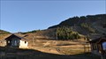
 view gallery view galleryN48.9 km |  Chair Lift 2 ~ White Pass Ski Area, Washington Chair Lift 2 ~ White Pass Ski Area, Washington
in Aerial Lifts This is one of three chair lifts at the base of the White Pass Ski Area on US Highway 12 in central Washington. posted by: brwhiz location: Washington date approved: 12/04/2013 last visited: 05/17/2014 |
 view gallery view galleryN48.9 km | Great White Express Chair Lift ~ White Pass Ski Area, Washington in Aerial Lifts This is one of three chair lifts at the base of the White Pass Ski Area on US Highway 12 in central Washington. posted by: brwhiz location: Washington date approved: 12/04/2013 last visited: never |
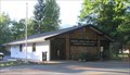
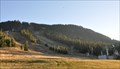
 view gallery view galleryN48.9 km |  White Pass Ski Area White Pass Ski Area
in Winter Sports Locations This ski area is located at the summit of White Pass on US Highway 12 between Centralia and Yakima, south of Mount Rainier, in central Washington. posted by: brwhiz location: Washington date approved: 12/09/2013 last visited: 05/17/2014 |
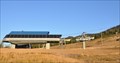
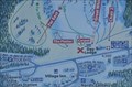 view gallery view galleryN48.9 km |  White Pass Ski Area ~ Day Lodge White Pass Ski Area ~ Day Lodge
in 'You Are Here' Maps You Are Here at the east side of the Day Lodge at the White Pass Ski Area on US Highway 12. posted by: brwhiz location: Washington date approved: 12/04/2013 last visited: never |
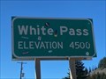 view gallery view galleryN49.1 km | White Pass - Packwood, WA - 4500' in Elevation Signs U.S. Highway 12 between Packwood and Rimrock Lake. posted by: WR7X location: Washington date approved: 10/04/2020 last visited: 12/29/2022 |
|