 view gallery view gallery SE0.8 km SE0.8 km
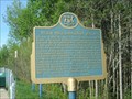
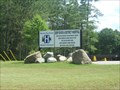
|   "NUCLEAR POWER DEMONSTRATION REACTOR" - Rolphton "NUCLEAR POWER DEMONSTRATION REACTOR" - Rolphton
in Ontario Provincial Plaques On June 4, 1962 the Nuclear Power Demonstration (NPD) Reactor 3 km east of Rolphton supplied the Ontario power grid with the first nuclear-generated electricity in Canada. posted by:  scotian scotian location: Ontario, Canada date approved: 07/17/2011 last visited: 10/05/2022 |
 view gallery view gallery E6 km E6 km
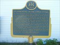
| "STEAMBOATING ON THE UPPER OTTAWA" - Laurentian Hills in Ontario Provincial Plaques A Plaque denoting the history of steamboating on the Ottawa River. The plaque is outside of the Schoolhouse Museum. posted by: scotian location: Ontario, Canada date approved: 07/17/2011 last visited: 10/05/2022 |
 view gallery view gallery W9.5 km W9.5 km
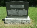
|  100 - Augustus "Gus" Meilleur - Mackey, Ontario 100 - Augustus "Gus" Meilleur - Mackey, Ontario
in Headstones of Centenarians Augustus "Gus" Meilleur was born at Meilleur's Bay, one of 12 children of Joseph and Almira Moore Meilleur. Gus saw many changes in the area during a life time of logging, railroad work, farming, camp cooking and store keeping. posted by: scotian location: Ontario, Canada date approved: 07/16/2011 last visited: 07/16/2011 |
 view gallery view gallerySE10.3 km |  CPR North Bay Sub, MP 10.3 CPR North Bay Sub, MP 10.3
in Canadian Benchmarks CGC Vertical Bench Mark location on the Canadian Pacific Railway's North Bay Subdivision, Mile Post 10.3 posted by: bandsaw1 location: Ontario, Canada date approved: 03/28/2010 last visited: never |
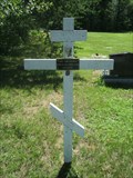 view gallery view gallerySE15.8 km |  Pawel (Sam) Kukzmicz, Deep River Cemetery, Ontario Pawel (Sam) Kukzmicz, Deep River Cemetery, Ontario
in Homemade Tombstones A homemade wooden cross in the Deep River Cemetery in Deep River Ontario. posted by: scotian location: Ontario, Canada date approved: 07/17/2011 last visited: 07/18/2011 |
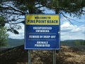 view gallery view gallerySE16.7 km |  Pine Point Beach - Deep River Ontario Pine Point Beach - Deep River Ontario
in Beaches Pine Point Beach is a beautiful sandy beach on the Ottawa River in Deep River Ontario. posted by: scotian location: Ontario, Canada date approved: 06/21/2011 last visited: 07/17/2011 |
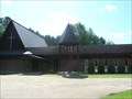 view gallery view gallerySE17.2 km |  Faith Lutheran Church - Deep River, Ontario Faith Lutheran Church - Deep River, Ontario
in Lutheran Churches Faith Lutheran Church is located at the corner of Avon and Ridge Rd. in Deep River Ontario. posted by: scotian location: Ontario, Canada date approved: 07/16/2011 last visited: 03/15/2013 |
 view gallery view gallerySE17.7 km |  MacDonald St. - Deep River Ontario MacDonald St. - Deep River Ontario
in Your Name Here My last name on a sign at the corner of MacDonald St. and Ridge Rd. in Deep River Ontario. posted by: scotian location: Ontario, Canada date approved: 06/23/2011 last visited: 03/15/2013 |
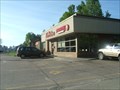 view gallery view gallerySE17.7 km |  Tim Horton's - Deep River, Ontario Tim Horton's - Deep River, Ontario
in Tim Horton's Restaurants Tim Horton's on Highway 17 in Deep River, Ontario. posted by: scotian location: Ontario, Canada date approved: 05/25/2011 last visited: 06/05/2015 |
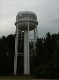 view gallery view gallerySE18 km |  Water Tower - Deep River, Ontario Water Tower - Deep River, Ontario
in Water Towers Water tower on Highway 17 in Deep River, Ontario. posted by: Slyyy location: Ontario, Canada date approved: 06/12/2011 last visited: 04/03/2022 |
 view gallery view gallerySE18.2 km |  FIRST - Canada's Nuclear Laboratory FIRST - Canada's Nuclear Laboratory
in First of its Kind A monument showing two electrons in orbit at the home of Canada's first nuclear reactor site. posted by: Loonwatcher location: Ontario, Canada date approved: 05/19/2015 last visited: 10/05/2022 |
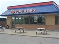 view gallery view gallerySE18.2 km |  Burger King - Hwy 17 - Deep River, Ontario Burger King - Hwy 17 - Deep River, Ontario
in Burger King Restaurants A Burger King catering to the hungry traveller. posted by: Loonwatcher location: Ontario, Canada date approved: 06/09/2015 last visited: never |
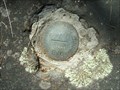
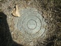
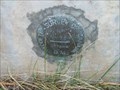 view gallery view gallerySE18.5 km | 70U480 in Canadian Benchmarks A Canadian Geodetic Survey Benchmark on the RC Church in Deep River posted by: scotian location: Ontario, Canada date approved: 10/27/2009 last visited: 07/17/2011 |
 view gallery view gallerySE19.8 km |  Deep River & District Hospital - Deep River, Ontario Deep River & District Hospital - Deep River, Ontario
in Hospitals The Deep River and District Hospital is located in Deep River, Ontario along Highway 17. posted by: scotian location: Ontario, Canada date approved: 07/08/2011 last visited: 03/15/2013 |
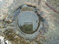
 view gallery view gallerySE20.8 km | 70U481 in Canadian Benchmarks A Canadian Geodetic Survey Benchmark on Highway 17 outside of Deep River posted by: scotian location: Ontario, Canada date approved: 05/21/2010 last visited: 07/17/2011 |
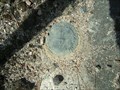 view gallery view gallerySE20.8 km | 883007 in Canadian Benchmarks A Canadian Geodetic Survey Benchmark on Highway 17 outside of Deep River. posted by: scotian location: Ontario, Canada date approved: 05/18/2010 last visited: 07/17/2011 |
 view gallery view gallerySE20.8 km | 68D0081 in Canadian Benchmarks A Control Survey mark for the Department of Highways Ontario on Highway 17 outside of Deep River posted by: scotian location: Ontario, Canada date approved: 05/19/2010 last visited: 07/17/2011 |
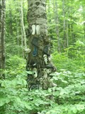 view gallery view gallerySE22.7 km |  Shoe Tree - Chalk River Ontario Shoe Tree - Chalk River Ontario
in Shoe Trees There are actually two shoe trees close to each other on Wylie Rd. outside of Chalk River Ontario. I have no idea why they were created. posted by: scotian location: Ontario, Canada date approved: 06/25/2011 last visited: 07/17/2011 |
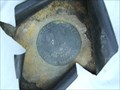
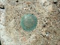
 view gallery view gallerySE24.1 km | 70U483 in Canadian Benchmarks A Canadian Geodetic Survey Benchmark at the junction of Highway 17 and Kings Road in Deep River posted by: scotian location: Ontario, Canada date approved: 10/27/2009 last visited: 07/17/2011 |
 view gallery view gallerySE25.6 km | 70U484 in Canadian Benchmarks A Canadian Geodetic Survey Benchmark on a concrete box culvert on Highway 17 in Chalk River posted by: scotian location: Ontario, Canada date approved: 05/21/2010 last visited: 07/17/2011 |
 view gallery view gallerySE26.1 km | 93U674 in Canadian Benchmarks A Canadian Geodetic Survey Benchmark in a cemetery in Chalk River, Ontario. posted by: scotian location: Ontario, Canada date approved: 08/21/2011 last visited: 08/24/2011 |
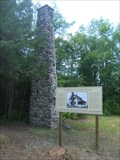 view gallery view gallerySE28.3 km |  Lonely Chimney - Chalk River Ontario Lonely Chimney - Chalk River Ontario
in Lonely Chimneys A lonely chimney on Clouthier Rd. in the Petawawa Research Forest in Chalk River Ontario. This chimney is the sole remaining structure of the Petawawa Forest Experiment Station (PFES) founded in 1918. posted by: scotian location: Ontario, Canada date approved: 06/21/2011 last visited: 09/24/2011 |
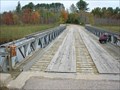 view gallery view gallerySE29.1 km |  The Forestry Road Bridge, Petawawa Research Forest, Ontario, Canada The Forestry Road Bridge, Petawawa Research Forest, Ontario, Canada
in Bailey Bridges On a back road in the Petawawa Research Forest this short Bailey Bridge spans the Chalk River. posted by: bluelamb03 location: Ontario, Canada date approved: 10/16/2011 last visited: 10/16/2011 |
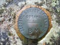 view gallery view gallerySE29.3 km | 28U96S in Canadian Benchmarks A Canadian Geodetic Survey Benchmark in the Petawawa Forestry Institute. posted by: scotian location: Ontario, Canada date approved: 10/27/2009 last visited: 07/17/2011 |
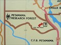 view gallery view gallerySE31.1 km |  You Are Here - Petawawa Research Forest - Chalk River Ontario You Are Here - Petawawa Research Forest - Chalk River Ontario
in 'You Are Here' Maps A Tourist Information map of the Townships of Rolph Buchanan Wylie and McKay in Ontario. You Are Here at the Petawawa Research Forest. posted by: scotian location: Ontario, Canada date approved: 06/21/2011 last visited: 10/01/2011 |
|