 view gallery view gallery S1.8 km S1.8 km
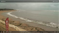
|   Webcam Plage de la Perroche - Dolus d'Oléron, France Webcam Plage de la Perroche - Dolus d'Oléron, France
in Web Cameras [EN] Static webcam broadcasting live images, located on the roof of the sailing school of the Dolus d'Oléron beach.
[FR] Webcam statique diffusant des images en direct, située sur le toit de l'école de voile de la plage de Dolus d'Oléron. posted by:  pmaupin pmaupin location: Nouvelle-Aquitaine, France date approved: 07/27/2019 last visited: never |
 view gallery view gallery W2.1 km W2.1 km
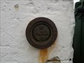
|  Syndicat d'initiative de la Cotinière Syndicat d'initiative de la Cotinière
in French Benchmarks repère bourdaloue posted by: Tooms et Jess location: Nouvelle-Aquitaine, France date approved: 11/15/2013 last visited: 02/23/2023 |
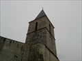
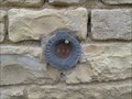 view gallery view galleryW2.4 km | Eglise de la Cotinière in French Benchmarks repère de nivellement cylindrique posted by: Tooms et Jess location: Nouvelle-Aquitaine, France date approved: 11/15/2013 last visited: 02/23/2023 |
 view gallery view gallery E2.7 km E2.7 km
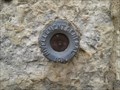
| Mairie de Dolus d'oléron in French Benchmarks repère de nivellement cylindrique posted by: Tooms et Jess location: Nouvelle-Aquitaine, France date approved: 11/15/2013 last visited: 02/23/2023 |
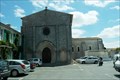
 view gallery view galleryE2.9 km | Eglise de Dolus d'Oléron in French Benchmarks repère de nivellement cylindrique posted by: Tooms et Jess location: Nouvelle-Aquitaine, France date approved: 11/15/2013 last visited: 02/23/2023 |
 view gallery view galleryE2.9 km | Eglise de Dolus d'Oléron in French Benchmarks réseau géodésique de détail posted by: Tooms et Jess location: Nouvelle-Aquitaine, France date approved: 11/15/2013 last visited: 02/23/2023 |
 view gallery view gallery N3.1 km N3.1 km
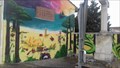
|  Mur peint - Saint-Pierre d'Oléron, Charente-Maritime Mur peint - Saint-Pierre d'Oléron, Charente-Maritime
in Murals Un magnifique mur peint
A wonderfull mural posted by: Caty1723 location: Nouvelle-Aquitaine, France date approved: 12/23/2017 last visited: 02/23/2023 |
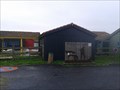
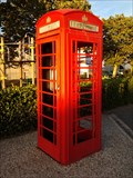 view gallery view galleryN3.2 km |  Cabine Téléphonique Rouge - Saint-Pierre-d'Oléron, France Cabine Téléphonique Rouge - Saint-Pierre-d'Oléron, France
in Red Telephone Boxes [FR] Une cabine téléphonique rouge dans la première ville de l'île d'Oléron. [EN] A red telephone box in the largest city on the Oléron island. posted by: RakeInTheCache location: Nouvelle-Aquitaine, France date approved: 10/12/2014 last visited: 04/02/2018 |
 view gallery view galleryN7.4 km | Eglise de st Georges d'Oléron in French Benchmarks repère de nivellement cylindrique posted by: Tooms et Jess location: Nouvelle-Aquitaine, France date approved: 07/15/2014 last visited: 02/23/2023 |
 view gallery view galleryN7.4 km | SAINT-GEORGES-D'OLERON VII in French Benchmarks repère géodésique de détail posted by: Tooms et Jess location: Nouvelle-Aquitaine, France date approved: 07/15/2014 last visited: 02/23/2023 |
 view gallery view gallery SE7.7 km SE7.7 km
|  Adolphe BRERET. Grand Village. France Adolphe BRERET. Grand Village. France
in Stolpersteine Un pavé à la mémoire de Adolphe Breret posted by: lulu_et_compagnie location: Nouvelle-Aquitaine, France date approved: 03/05/2022 last visited: 02/23/2023 |
 view gallery view gallerySE8.2 km |  Port des Salines - Ile d'Oléron, France Port des Salines - Ile d'Oléron, France
in Salt Pans and Mines Port des Salines, natural setting labeled Pole Nature, proposes to unveil the history of salt production oléronaise and know-how saulnier. posted by: Tooms et Jess location: Nouvelle-Aquitaine, France date approved: 12/05/2013 last visited: 02/23/2023 |
 view gallery view galleryN8.5 km |  Plage des Saumonards. Oleron . France Plage des Saumonards. Oleron . France
in Nude Beaches Plage naturiste des Saumonards posted by: lulu_et_compagnie location: Nouvelle-Aquitaine, France date approved: 09/17/2015 last visited: 02/23/2023 |
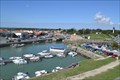 view gallery view gallerySE9.2 km |  Le Port du Château-d’Oléron - Atlantique - Charente-Maritime - France Le Port du Château-d’Oléron - Atlantique - Charente-Maritime - France
in Commercial Fishing Ports [EN] The Port du Château-d'Oléron is a major center for oyster transit
[FR] Le port du Château-d’Oléron est un important centre de transit d’huîtres posted by: pmaupin location: Nouvelle-Aquitaine, France date approved: 11/09/2016 last visited: 02/23/2023 |
 view gallery view galleryE9.2 km |  Citadelle du Château-d'Oléron - Château-d'Oléron, France Citadelle du Château-d'Oléron - Château-d'Oléron, France
in Monuments Historiques Français [FR] La citadelle du Château-d'Oléron est un ouvrage militaire édifié de 1630 à 1704 afin de protéger la partie méridionale de l'île d'Oléron.
[EN] The citadel of Château-d'Oléron is a military structure built from 1630 to 1704 to protect the southern part of the island of Oléron. posted by: pmaupin location: Nouvelle-Aquitaine, France date approved: 06/23/2018 last visited: 02/23/2023 |
 view gallery view galleryE9.2 km |  Citadelle du Château-d'Oléron - Château-d'Oléron, France Citadelle du Château-d'Oléron - Château-d'Oléron, France
in Wikipedia Entries [EN] The citadel of Château-d'Oléron is a military structure built from 1630 to 1704 to protect the southern part of the island of Oléron.
[FR] La citadelle du Château-d'Oléron est un ouvrage militaire édifié de 1630 à 1704 afin de protéger la partie méridionale de l'île d'Oléron. posted by: pmaupin location: Nouvelle-Aquitaine, France date approved: 06/22/2018 last visited: 02/23/2023 |
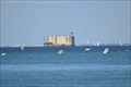
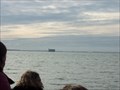 view gallery view gallery NE11.4 km NE11.4 km
| Repere geodesique SAINT-GEORGES-D'OLERON VIII in French Benchmarks Fort Boyard comme à la Television. posted by: sara et gege location: Nouvelle-Aquitaine, France date approved: 10/24/2015 last visited: 02/23/2023 |
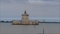
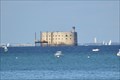 view gallery view galleryNE11.4 km |  Fort Boyard - Ile-d'Aix, France Fort Boyard - Ile-d'Aix, France
in Satellite Imagery Oddities [EN] Fort Boyard is a fortification located on a high bottom formed of a sandbar at the origin, called the "Boyard's lanyard" which is discovered at low tide. [FR]Le fort Boyard est une fortification située sur un haut fond formé d'un banc de sable à l'origine, appelé la « longe de Boyard » qui se découvre à marée basse. posted by: pmaupin location: Nouvelle-Aquitaine, France date approved: 07/26/2019 last visited: 02/23/2023 |
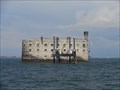 view gallery view galleryNE11.4 km |  Fort Boyard - Ile-d'Aix, Nouvelle Aquitaine, France Fort Boyard - Ile-d'Aix, Nouvelle Aquitaine, France
in Historic Forts [EN]Fort Boyard is a fortification located on a high bottom.
[FR] Le fort Boyard est une fortification située sur un haut fond. posted by: sara et gege location: Nouvelle-Aquitaine, France date approved: 03/13/2019 last visited: 02/23/2023 |
 view gallery view galleryNE11.4 km | Fort Boyard - Ile-d'Aix, France in Wikipedia Entries [EN] Fort Boyard is a fortification located on a high bottom formed of a sandbar at the origin, called the "Boyard's lanyard" which is discovered at low tide.
[FR]Le fort Boyard est une fortification située sur un haut fond formé d'un banc de sable à l'origine, appelé la « longe de Boyard » qui se découvre à marée basse. posted by: pmaupin location: Nouvelle-Aquitaine, France date approved: 06/23/2018 last visited: 02/23/2023 |
 view gallery view galleryNE11.4 km | Fort Boyard - Ile-d'Aix, France in Monuments Historiques Français [FR] Le fort Boyard est une fortification située sur un haut fond formé d'un banc de sable à l'origine, appelé la « longe de Boyard » qui se découvre à marée basse.
[EN]Fort Boyard is a fortification located on a high bottom formed of a sandbar at the origin, called the "Boyard's lanyard" which is discovered at low tide. posted by: pmaupin location: Nouvelle-Aquitaine, France date approved: 06/23/2018 last visited: 02/23/2023 |
 view gallery view galleryN11.6 km | Mur peint - La Brée-les-bains - Ile d'Oléron, Charente-Maritime in Murals Un magnifique mur peint face à la mer
A beautiful painted wall facing the sea posted by: Caty1723 location: Nouvelle-Aquitaine, France date approved: 01/14/2018 last visited: 01/14/2018 |
 view gallery view gallerySE11.7 km | Fort Louvois - Bourcefranc in Historic Forts Dernier ouvrage de fortification maritime commandé par Louis XIV posted by: Caty1723 location: Nouvelle-Aquitaine, France date approved: 07/07/2017 last visited: 02/23/2023 |
![Image for [Arm] La Brée-les-Bains - Canon](https://img.geocaching.com/waymarking/small/9164fee6-4263-4099-9ffb-36ef45b570cc.jpg) view gallery view galleryN12.1 km |  [Arm] La Brée-les-Bains - Canon [Arm] La Brée-les-Bains - Canon
in Static Artillery Displays This cannon is displayed in front of the sea.
---
Canon exposé en bord de mer. posted by: BmarcW location: Nouvelle-Aquitaine, France date approved: 05/20/2015 last visited: 07/21/2018 |
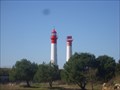 view gallery view galleryNE14 km |  Phare de l'ile d'Aix . France Phare de l'ile d'Aix . France
in Coastal Lighthouses Phare de l'ile d'Aix posted by: lulu_et_compagnie location: Nouvelle-Aquitaine, France date approved: 03/29/2014 last visited: 07/22/2016 |
|