 view gallery view gallery W10.3 km W10.3 km
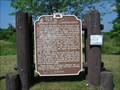
|   Historic Rush City Ferry Landing Historic Rush City Ferry Landing
in Ferries and Ferry Landings The Rush City Ferry Landing is on the St Croix National Riverway with matching landings on the Minnesota and Wisconsin sides of the river. The ferry is no longer operational. posted by:  Java and Me Java and Me location: Minnesota date approved: 08/05/2012 last visited: never |
 view gallery view gallery NE10.9 km NE10.9 km
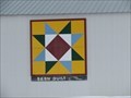
|  Burnett County Barn Quilt – Grantsburg, WI Burnett County Barn Quilt – Grantsburg, WI
in Painted Barn Quilts This colorful eight pointed star is mounted on one of the agricultural buildings at the Burnett County Fairgrounds. posted by:  wildernessmama wildernessmama location: Wisconsin date approved: 03/12/2018 last visited: never |
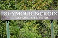 view gallery view galleryW11.1 km |  Seymour-St Croix School Site No 60 Seymour-St Croix School Site No 60
in Minnesota Historical Markers This Seymour-St Croix School Site No 60 historical marker is one of a series of wooden markers placed by the North Chisago Historical Society. It marks the location of the site where School District No 60 once stood. posted by: Java and Me location: Minnesota date approved: 08/08/2012 last visited: never |
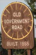 view gallery view galleryW14.3 km | Old Government Road #1 in Minnesota Historical Markers This historical marker is one of a series of wooden markers placed by the North Chisago Historical Society. It represents a wagon wheel and marks the Old Government Road, also known as the Point Douglas Superior Military Road. posted by: Java and Me location: Minnesota date approved: 08/11/2012 last visited: never |
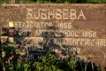 view gallery view galleryW14.3 km | Rushseba, Minnesota in Minnesota Historical Markers This Rushseba Township historical marker is one of a series of wooden markers placed by the North Chisago Historical Society. Located on the Old Government Road, it shows where the Stage Stop, School, Post Office, Saw Mill and Flour Mill once stood. posted by: Java and Me location: Minnesota date approved: 08/05/2012 last visited: never |
 view gallery view galleryW14.5 km | Peers School Site No 18 in Minnesota Historical Markers This Peers School Site No 18 historical marker is one of a series of wooden markers placed by the North Chisago Historical Society. Located on the Old Government Road, it marks the location of the school site for School District No 18. posted by: Java and Me location: Minnesota date approved: 08/06/2012 last visited: never |
 view gallery view galleryW14.6 km | Old Government Road #2 in Minnesota Historical Markers This historical marker is one of a series of wooden markers placed by the North Chisago Historical Society. It represents a wagon wheel and marks the Old Government Road, also known as the Point Douglas Superior Military Road. posted by: Java and Me location: Minnesota date approved: 08/11/2012 last visited: never |
 view gallery view galleryW14.6 km | French School Site No 47 in Minnesota Historical Markers This French School Site No 47 historical marker is one of a series of wooden markers placed by the North Chisago Historical Society. It marks the location of the site where School District No 47 once stood. posted by: Java and Me location: Minnesota date approved: 08/08/2012 last visited: never |
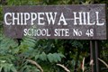 view gallery view gallery SW15.6 km SW15.6 km
| Chippewa Hill School Site No 48 in Minnesota Historical Markers This Chippewa Hill School Site No 48 historical marker is one of a series of wooden markers placed by the North Chisago Historical Society. It marks the location of the site where School District No 48 once stood. posted by: Java and Me location: Minnesota date approved: 08/08/2012 last visited: never |
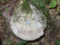 view gallery view gallery S15.9 km S15.9 km
|  MINN 4 MINN 4
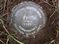
in U.S. Benchmarks USGS mark set in Wild River State Park, Amador Township, Minnesota. posted by: msrubble location: Minnesota date approved: 09/11/2011 last visited: never |
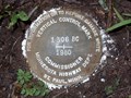 view gallery view galleryS16.4 km | 1306 BG in U.S. Benchmarks Minnesota Highway Department vertical control disk along park road in Wild River State Park. posted by: msrubble location: Minnesota date approved: 09/03/2011 last visited: never |
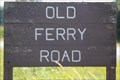 view gallery view galleryW16.7 km | Old Ferry Road in Minnesota Historical Markers This Old Ferry Road historical marker is one of a series of wooden markers placed by the North Chisago Historical Society. It marks the road that used to go to the Deering Ferry (also called the Rush City Ferry). posted by: Java and Me location: Minnesota date approved: 08/09/2012 last visited: never |
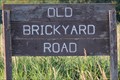 view gallery view galleryW17.1 km | Old Brick Yard Road in Minnesota Historical Markers This Old Brick Yard Road historical marker is one of a series of wooden markers placed by the North Chisago Historical Society. It marks the road that used to go by the Rush City Pressed Brick Company. posted by: Java and Me location: Minnesota date approved: 08/09/2012 last visited: never |
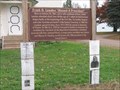 view gallery view gallerySW17.2 km | Frank O. Lowden ~ "Almost a President" in Minnesota Historical Markers Frank O. Lowden was born in Chisago County, Minnesota on January 26, 1861. Starting his career as a school teacher, he saved enough money to attend Union College of Law, now Northwestern University School of Law. posted by: MNSearchers location: Minnesota date approved: 11/03/2007 last visited: never |
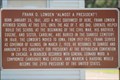 view gallery view gallerySW17.2 km | Frank O. Lowden "Almost a President"! in Minnesota Historical Markers This historical marker is located in front of the Sunrise, Minnesota town hall where Frank Orren Lowden attended school. posted by: Java and Me location: Minnesota date approved: 08/07/2012 last visited: never |
 view gallery view galleryS17.4 km | 1306 BF in U.S. Benchmarks A Minnesota Highway Department vertical control disk just inside Wild River State Park, Amador Township. posted by: msrubble location: Minnesota date approved: 09/03/2011 last visited: never |
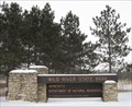 view gallery view galleryS17.5 km |  Wild River SP - Minnesota Wild River SP - Minnesota
in State/Provincial Parks Wild River State Park, MN posted by: joshismycopilot location: Minnesota date approved: 01/18/2009 last visited: 01/18/2009 |
 view gallery view gallerySW17.5 km | Richard Widmark's Birthsite, "Hollywood Legend!" in Minnesota Historical Markers This historical marker is located in Sunrise, Minnesota, marking the place where Richard Widmark was born. posted by: Java and Me location: Minnesota date approved: 08/07/2012 last visited: 11/03/2013 |
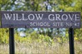 view gallery view galleryW20 km | Willow Grove School Site No 42 in Minnesota Historical Markers This Willow Grove School Site No 42 historical marker is one of a series of wooden markers placed by the North Chisago Historical Society. Located near Harris, it marks the location where the rural Willow Grove School once stood posted by: Java and Me location: Minnesota date approved: 08/07/2012 last visited: never |
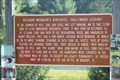
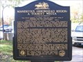 view gallery view gallerySW21.4 km | Minnesota's Arrowhead Region: A Tourist Mecca in Minnesota Historical Markers Lured by America's premier wilderness canoe region, Lake Superiors rugged shoreline and cascading streams, and Duluth's reputation as America's great inland seaport, tourists have been coming to northeastern Minnesota since the 1890's. posted by: MNSearchers location: Minnesota date approved: 11/03/2007 last visited: 10/06/2013 |
 view gallery view gallery SE23.3 km SE23.3 km
|  Danish Dairy Cooperative Danish Dairy Cooperative
in Wisconsin Historical Markers Danish Dairy Cooperative Marker in Luck posted by: frankhj location: Wisconsin date approved: 07/22/2007 last visited: 09/15/2015 |
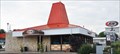 view gallery view gallery NW23.5 km NW23.5 km
|  A&W - Pine City, Minnesota A&W - Pine City, Minnesota
in A + W Restaurants This restaurant is near the highway exit but just off on the Business Route. posted by: SageInThyme82 location: Minnesota date approved: 08/14/2015 last visited: 03/12/2018 |
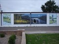 view gallery view galleryNW24.1 km |  Minnesota Outdoors Minnesota Outdoors
in Murals Scene depicting the great Minnesota Outdoors posted by: beagle39z location: Minnesota date approved: 06/07/2007 last visited: 03/12/2018 |
 view gallery view gallery N24.1 km N24.1 km
| Crex Meadows in Wisconsin Historical Markers Crex Meadows marker N. of Grantsburg. Marker is on North Refuge Road 3 miles E. of F. This is a narrow but paved road. There are no signs that let you know the marker is there. posted by: frankhj location: Wisconsin date approved: 07/22/2007 last visited: 12/19/2011 |
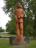 view gallery view galleryNW24.3 km |  Pine City's "Voyageur" Pine City's "Voyageur"
in Outside Wooden Display Carvings Pine City's "Voyageur" stands watch over the Snake River, Cross Lake and historic downtown Pine City, MN. posted by: beagle39z location: Minnesota date approved: 06/08/2007 last visited: 03/12/2018 |
|