 view gallery view gallery NE7.1 km NE7.1 km
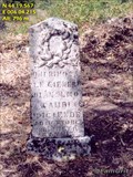
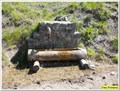
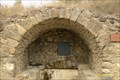
|   Acient cemetery near Clamensane (F) Acient cemetery near Clamensane (F)
in Abandoned Cemeteries A acient cemetry with only two graves left posted by:  FamGrit FamGrit location: Provence-Alpes-Côte d'Azur, France date approved: 01/24/2006 last visited: never |
 view gallery view gallery W7.7 km W7.7 km
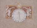
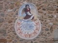
|  Vitruvian Man Sundial, Le Poet, Hautes Alpes, France Vitruvian Man Sundial, Le Poet, Hautes Alpes, France
in Sundials In the hill village of Le Poet in the Laragnais area of Haute Alpes the is a sundial on the village church based on the Vitruvian Man image of Leonardo de Vinci. posted by:  arby101ca arby101ca location: France date approved: 10/23/2009 last visited: never |
 view gallery view galleryNE8.2 km |  Clamensane Aquaduct Clamensane Aquaduct
in Ancient Aqueducts Ancient Roman auqaduct at 819 m near Clamensane in France. posted by: FamGrit location: France date approved: 01/24/2006 last visited: never |
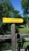
 view gallery view galleryNE8.4 km |  845 m - Font Reynier - Clamensane, Paca, France 845 m - Font Reynier - Clamensane, Paca, France
in Elevation Signs Cette altitude est présente sur un panneau à destination des randonneurs posted by: YvesProvence location: Provence-Alpes-Côte d'Azur, France date approved: 01/10/2018 last visited: never |
 view gallery view galleryNE8.9 km |  Fontaine rustique dans la montagne - Clamensane, Paca, France Fontaine rustique dans la montagne - Clamensane, Paca, France
in Fountains Une fontaine dans la montagne posted by: YvesProvence location: Provence-Alpes-Côte d'Azur, France date approved: 01/10/2018 last visited: never |
 view gallery view galleryNE9.5 km | 1290 m - Chapelle Saint Amand - Clamensane, Paca, France in Elevation Signs Cette altitude est présente sur un panneau à destination des randonneurs posted by: YvesProvence location: Provence-Alpes-Côte d'Azur, France date approved: 01/10/2018 last visited: never |
 view gallery view galleryNE9.5 km |  La chapelle Saint Amand - Clamensane, Paca, France La chapelle Saint Amand - Clamensane, Paca, France
in Waychapels La chapelle Saint Amand sur les hauteurs de Clamensane. posted by: YvesProvence location: Provence-Alpes-Côte d'Azur, France date approved: 01/12/2018 last visited: never |
 view gallery view galleryNE9.5 km |  La chapelle Saint Amand - Clamensane, Paca, France La chapelle Saint Amand - Clamensane, Paca, France
in This Old Church La chapelle Saint Amand sur les hauteurs de Clamensane. posted by: YvesProvence location: Provence-Alpes-Côte d'Azur, France date approved: 01/10/2018 last visited: never |
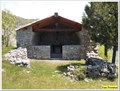 view gallery view galleryNE9.5 km | La chapelle Saint Amand - Clamensane, Paca, France in Roman Catholic Churches La chapelle Saint Amand sur les hauteurs de Clamensane. posted by: YvesProvence location: Provence-Alpes-Côte d'Azur, France date approved: 01/10/2018 last visited: never |
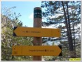 view gallery view galleryNE9.7 km | 1237 m - Col de la Croix - Clamensane, Paca, France in Elevation Signs Cette altitude est présente sur un panneau à destination des randonneurs posted by: YvesProvence location: Provence-Alpes-Côte d'Azur, France date approved: 01/10/2018 last visited: never |
 view gallery view galleryW9.7 km |  Le lac de Mison- Upaix- PACA- France Le lac de Mison- Upaix- PACA- France
in Natural Lakes FR: Le lax collinaire de Mison-Upaix- France.
EN: The hill lax of Mison-Upaix- France posted by: SISABIEL location: Provence-Alpes-Côte d'Azur, France date approved: 06/15/2018 last visited: never |
 view gallery view galleryW10 km | 630 m. Lac de Mison- Mison- Alpes de Hautes Provence- PACA- France in Elevation Signs FR: Panneau indicateur pour les randonneurs. EN: Signpost for hikers. posted by: SISABIEL location: Provence-Alpes-Côte d'Azur, France date approved: 06/01/2018 last visited: never |
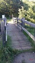 view gallery view galleryW10 km |  Le petit pont en bois du lac de Mison- Alpes de Hautes Provence Le petit pont en bois du lac de Mison- Alpes de Hautes Provence
in Hiking Path Footbridges FR: Le petit pont en bois du lac de Mison.
EN: The little wooden bridge of Lake Mison. posted by: SISABIEL location: Provence-Alpes-Côte d'Azur, France date approved: 06/03/2018 last visited: never |
 view gallery view galleryW10.1 km | Penitents Chapel Sundial, Upaix, Hautes, Alpes, France in Sundials A sundial by Remi Potey on the penitents chapel in Upaix, in the Laragnais of Haute Alpes posted by: arby101ca location: France date approved: 10/23/2009 last visited: 10/21/2017 |
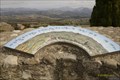 view gallery view galleryW10.1 km |  3 tables orientation à Upaix- Upaix- Hautes-Alpes- PACA- France 3 tables orientation à Upaix- Upaix- Hautes-Alpes- PACA- France
in Orientation Tables 3 tables orientation pour une magnifique vue à 360° posted by: SISABIEL location: Provence-Alpes-Côte d'Azur, France date approved: 11/05/2017 last visited: never |
 view gallery view galleryW10.3 km | ") Lavoir de Upaix- Hautes-Alpes- PACA- France Lavoir de Upaix- Hautes-Alpes- PACA- France
in Lavoir (wash houses) Lavoir de Upaix. posted by: SISABIEL location: Provence-Alpes-Côte d'Azur, France date approved: 11/05/2017 last visited: never |
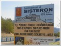 view gallery view galleryW10.6 km |  Blason de Sisteron - Sisteron, Paca, France Blason de Sisteron - Sisteron, Paca, France
in Coats of Arms Le blason de Sisteron sur un panneau d'entrée de la commune posted by: YvesProvence location: Provence-Alpes-Côte d'Azur, France date approved: 08/25/2017 last visited: 06/04/2018 |
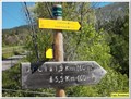
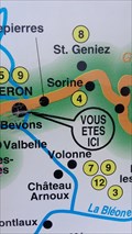
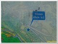 view gallery view galleryW10.6 km |  Vous êtes ici - Mison, Paca, France Vous êtes ici - Mison, Paca, France
in 'You Are Here' Maps La Carte de Ribiers-Val de Méouge posted by: YvesProvence location: Provence-Alpes-Côte d'Azur, France date approved: 08/23/2017 last visited: 11/14/2017 |
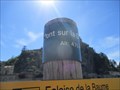 view gallery view gallery S10.9 km S10.9 km
| 470 m - Pont sur la Durance - Sisteron, Paca, France in Elevation Signs Un panneau comme on en trouve sur les chemins de randonnée posted by: YvesProvence location: Provence-Alpes-Côte d'Azur, France date approved: 07/16/2017 last visited: never |
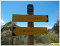
 view gallery view galleryS10.9 km | La France par les Sentiers - Sisteron, France in 'You Are Here' Maps Point info Rando, au carrefour des GR6 et de la GTPA posted by: JMRetSB location: Provence-Alpes-Côte d'Azur, France date approved: 05/18/2015 last visited: 05/11/2015 |
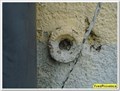 view gallery view galleryS10.9 km |  Repère de nivellement - I'.A.H3I3 - 2 - Sisteron, France Repère de nivellement - I'.A.H3I3 - 2 - Sisteron, France
in French Benchmarks Un répère de nivellement à Sisteron. A leveling mark in Sisteron. posted by: YvesProvence location: Provence-Alpes-Côte d'Azur, France date approved: 02/05/2021 last visited: 02/05/2021 |
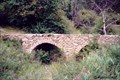
 view gallery view galleryS10.9 km |  Le pont de la Baume - Sisteron, Paca, France Le pont de la Baume - Sisteron, Paca, France
in Arch Bridges Le pont de la Baume actuel date de 1886 mais un autre l’avait précédé construit en « dos d’âne » en 1365. Un pont encore plus ancien a sûrement existé mais point de trace. posted by: YvesProvence location: Provence-Alpes-Côte d'Azur, France date approved: 07/16/2017 last visited: never |
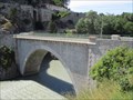 view gallery view galleryS10.9 km |  Le pont de la Baume - Sisteron, Paca, France Le pont de la Baume - Sisteron, Paca, France
in Stone Bridges Le pont de la Baume actuel date de 1886 mais un autre l’avait précédé construit en « dos d’âne » en 1365. Un pont encore plus ancien a sûrement existé mais point de trace. posted by: YvesProvence location: Provence-Alpes-Côte d'Azur, France date approved: 07/22/2017 last visited: never |
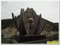 view gallery view galleryS10.9 km |  A pour nom la vie - Sisteron, France A pour nom la vie - Sisteron, France
in Abstract Public Sculptures Un œuvre à voir sur l'espace public.A work to be seen in the public space. posted by: YvesProvence location: France date approved: 02/05/2021 last visited: 03/02/2021 |
 view gallery view galleryS10.9 km | Equilibre - Sisteron, France in Abstract Public Sculptures Un œuvre à voir sur l'espace public.A work to be seen in the public space. posted by: YvesProvence location: Provence-Alpes-Côte d'Azur, France date approved: 02/05/2021 last visited: 03/02/2021 |
|