 view gallery view gallery SW0 km SW0 km
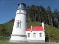
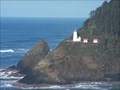
|   Heceta Head Lighthouse and Keepers Quarters - Florence, Oregon Heceta Head Lighthouse and Keepers Quarters - Florence, Oregon
in U.S. National Register of Historic Places The historic Heceta Head Lighthouse and Keepers Quarters near Florence, Oregon. posted by:  Volcanoguy Volcanoguy location: Oregon date approved: 10/21/2013 last visited: 07/03/2019 |
 view gallery view gallery S0 km S0 km
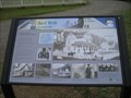
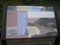
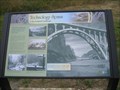
|  A Battle With the Elements - Heceta Head, Lane County, Oregon A Battle With the Elements - Heceta Head, Lane County, Oregon
in Oregon Historical Markers Historic marker at Heceta Head Lighthouse posted by:  ddtfamily ddtfamily location: Oregon date approved: 08/19/2013 last visited: never |
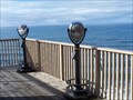
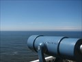 view gallery view gallerySW0 km |  Monocular-Heceta Head Lighthouse Vista Monocular-Heceta Head Lighthouse Vista
in Coin-Op Binoculars Coordinates lead to a landing at the base of Heceta Head Lighthouse. There is a 1/2 mile hike up to the lighthouse from the beach below. There is a $3.00 fee to park in the parking lot. posted by: TheBeanTeam location: Oregon date approved: 08/14/2007 last visited: 08/11/2014 |
 view gallery view gallery SE0 km SE0 km
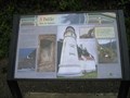
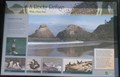
| Designed for Seafarer Safety in Oregon Historical Markers This history sign is located in Devils Elbow State Park. posted by: Volcanoguy location: Oregon date approved: 10/07/2013 last visited: 05/20/2013 |
 view gallery view gallery E0.2 km E0.2 km
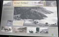
| Road Behind And Sea Beyond in Oregon Historical Markers This history sign is located in Devils Elbow State Park. posted by: Volcanoguy location: Oregon date approved: 10/07/2013 last visited: 05/20/2013 |
 view gallery view gallery NE0.2 km NE0.2 km
|  Heceta Head Lighthouse Heceta Head Lighthouse
in Coastal Lighthouses Walk a half mile for some of the greatest views of your life. posted by: cachegame location: Oregon date approved: 09/25/2006 last visited: 10/01/2022 |
 view gallery view gallerySE0.2 km | Hard Work - Heceta Head, Lane County, Oregon in Oregon Historical Markers Historical marker describing life as a lightstation keeper posted by: ddtfamily location: Oregon date approved: 08/19/2013 last visited: 09/30/2018 |
 view gallery view gallerySE0.2 km | A Rocky Refuge With a Fiery Past in Oregon Historical Markers This history sign is located in Devils Elbow State Park. posted by: Volcanoguy location: Oregon date approved: 10/07/2013 last visited: 05/20/2013 |
 view gallery view gallerySE0.3 km |  Heceta Head Lighthouse and Light Keeper’s house Heceta Head Lighthouse and Light Keeper’s house
in Lighthouse Bed and Breakfasts On one of the most rugged and picturesque sections of the Oregon coast. This lighthouse is considered to be one of the most photographed lighthouses in the world. posted by: TheBeanTeam location: Oregon date approved: 03/10/2006 last visited: 11/27/2020 |
 view gallery view gallerySE0.3 km |  Haunted- Heceta Head Lighthouse and Innkeepers House Haunted- Heceta Head Lighthouse and Innkeepers House
in Ghosts and Hauntings The resident ghost is said to be the spirit of a broken hearted mother who lost her child due to a fall from the cliffs or by drowning. posted by: TheBeanTeam location: Oregon date approved: 05/01/2007 last visited: 07/03/2019 |
 view gallery view gallerySE0.3 km |  Heceta Head Light Keepers' House Compass Rose - Lane County, Oregon Heceta Head Light Keepers' House Compass Rose - Lane County, Oregon
in Mosaics Mosaic compass Rose at the Keepers' House at Heceta Head Lighthouse posted by: ddtfamily location: Oregon date approved: 08/18/2013 last visited: never |
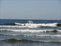 view gallery view gallerySE0.5 km |  Heceta Head, Cape Creek Beach Heceta Head, Cape Creek Beach
in Wavy Places In Lane County Oregon at Devils Elbow State Park, Cape Creek meets the Pacific Ocean at this point on a small beach nestled between Heceta Head and Devils Elbow. posted by: TheBeanTeam location: Oregon date approved: 08/14/2007 last visited: 11/27/2020 |
 view gallery view gallerySE0.5 km |  DESTINATION-Cape Creek-Pacific Ocean DESTINATION-Cape Creek-Pacific Ocean
in River Origins, Destinations and Confluences Cape Creek at Heceta Head State Park (which includes Devils Elbow State Park. Where Cape Creek meets the Pacific Ocean. posted by: TheBeanTeam location: Oregon date approved: 08/14/2007 last visited: 07/03/2019 |
 view gallery view gallerySE0.5 km | Heceta Head Lightstation - Lane County, Oregon in Oregon Historical Markers Marker describing the history of the Heceta Head Lighthouse posted by: ddtfamily location: Oregon date approved: 08/19/2013 last visited: 09/30/2018 |
 view gallery view gallerySE0.5 km | Cape Creek Bridge No. 01113 - Lane County, Oregon in U.S. National Register of Historic Places The Cape Creek Bridge was listed on the National Register on August 5th of 2005. posted by: TheBeanTeam location: Oregon date approved: 08/30/2007 last visited: 07/03/2019 |
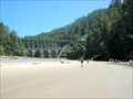
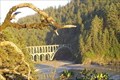
 view gallery view gallerySE0.5 km |  Heceta Head/Cape Creek Bridge & Tunnel Heceta Head/Cape Creek Bridge & Tunnel
in American Guide Series Heceta Head Lighthouse and the historic Cape Creek Bridge and Tunnel were mentioned in the 1940's edition of the Oregon: End of the Trail American Guide Series publication. posted by: TheBeanTeam location: Oregon date approved: 08/15/2007 last visited: 11/27/2020 |
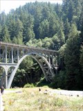
 view gallery view gallerySE0.5 km |  Cape Creek Bridge Cape Creek Bridge
in Arch Bridges Designed by Conde B. McCullough the Cape Creek bridge is unique in that it crosses the creek at this location and immediately enters a tunnel through the "Devils Elbow". The Cape Creek bridge was listed on the National Historic Register in 2005. posted by: TheBeanTeam location: Oregon date approved: 12/07/2007 last visited: 07/03/2019 |
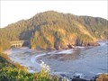
 view gallery view gallerySE0.6 km |  Devils Elbow, Oregon Devils Elbow, Oregon
in Geological Devilish Locations Devils Elbow on the central Oregon Coast. posted by: Volcanoguy location: Oregon date approved: 10/26/2005 last visited: 11/27/2020 |
 view gallery view gallerySE0.6 km | Technology Spans (Cape Creek Bridge) - Lane County, Oregon in Oregon Historical Markers Marker describing the historic Cape Creek Bridge posted by: ddtfamily location: Oregon date approved: 08/19/2013 last visited: never |
 view gallery view galleryS1.8 km |  Indian Maiden and Indian Brave - Florence, Oregon Indian Maiden and Indian Brave - Florence, Oregon
in Simulacra An Indian Brave and an Indian Maiden decorate the walls of the Sea Lion Cave. posted by: GT.US location: Oregon date approved: 02/07/2008 last visited: 08/25/2012 |
 view gallery view galleryS1.8 km |  Sea Lion Caves - Florence, Oregon Sea Lion Caves - Florence, Oregon
in Web Cameras Looking across the rocks where the Sea Lions play. posted by: GT.US location: Michigan date approved: 01/22/2008 last visited: 01/03/2015 |
 view gallery view galleryS1.8 km | Abraham Lincoln, Sea Lion Cave, Oregon in Simulacra Outline of Lincoln's profile in the rock. posted by: gypsie2 location: Oregon date approved: 01/02/2015 last visited: never |
 view gallery view galleryS1.8 km | Sea Lion Cave Binoculars, Florrence, Oregon in Coin-Op Binoculars Inside the cave itself. posted by: gypsie2 location: Oregon date approved: 01/04/2015 last visited: never |
 view gallery view galleryS1.8 km | BINO - Sea Lion Cave - Florence, Oregon in Coin-Op Binoculars From these Binoculars, you can see the Sea Lions on the rocks below. They are inside the area that you have to pay for admittance. posted by: GT.US location: Oregon date approved: 01/22/2008 last visited: 08/25/2012 |
 view gallery view galleryS1.8 km |  Sea Lion Caves Penny Smasher #1 - Florence, Oregon Sea Lion Caves Penny Smasher #1 - Florence, Oregon
in Penny Smashers This Penny Smasher is located in the gift shop. This machine is now located on a landing for the stairs down to the caves. Admission is required to access this machine. posted by: GT.US location: Oregon date approved: 01/21/2008 last visited: 01/01/2015 |
|