 view gallery view gallery SE5.3 km SE5.3 km
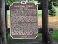
|   Thorstein Veblen (1857-1929) Thorstein Veblen (1857-1929)
in Wisconsin Historical Markers Thorstein Veblen Marker in Valders. posted by:  frankhj frankhj location: Wisconsin date approved: 07/24/2007 last visited: 05/11/2009 |
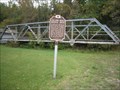 view gallery view gallery E10.1 km E10.1 km
| Collins Rd Bridge Span in Wisconsin Historical Markers A marker in the Pinecrest historical village near Manitowoc posted by:  Benron Benron location: Wisconsin date approved: 03/25/2010 last visited: 07/07/2015 |
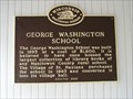 view gallery view gallery S11.6 km S11.6 km
| George Washington School in Wisconsin Historical Markers George Washington School Marker in St. Nazianz. The property is listed in the Wisconsin State Register of Historic Place. posted by: frankhj location: Wisconsin date approved: 07/24/2007 last visited: never |
 view gallery view galleryS11.7 km | St. Nazianz in Wisconsin Historical Markers St. Nazianz Marker in St. Nazianz. posted by: frankhj location: Wisconsin date approved: 07/24/2007 last visited: never |
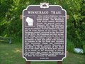 view gallery view galleryE15.3 km | Winnebago Trail in Wisconsin Historical Markers Winnebago Trail Marker in Silver Lake Park in Manitowoc County posted by: frankhj location: Wisconsin date approved: 07/13/2009 last visited: 08/24/2009 |
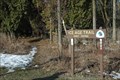
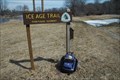 view gallery view galleryE18.2 km |  Ice Age Trail - Manitowoc Segment Ice Age Trail - Manitowoc Segment
in Ice Age Trail Manitowoc Segment Sign posted by: The Troops location: Wisconsin date approved: 10/14/2012 last visited: never |
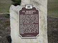 view gallery view gallery SW19 km SW19 km
| St. Martin's Church in Wisconsin Historical Markers St Martins Church Marker North of New Holstein. posted by: frankhj location: Wisconsin date approved: 04/19/2012 last visited: never |
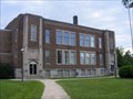 view gallery view galleryE19.5 km |  Manitowoc County Teachers College - Manitowoc, WI Manitowoc County Teachers College - Manitowoc, WI
in Former Schools Built in 1922 the Manitowoc County Teachers College now serves as the home for the Manitowoc County Historical Society. posted by: REUAHNESIE location: Wisconsin date approved: 08/06/2012 last visited: 10/10/2016 |
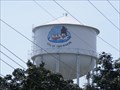
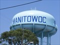 view gallery view galleryE20.4 km |  Reed Avenue Water Tower - Manitowoc, WI Reed Avenue Water Tower - Manitowoc, WI
in Water Towers This is one of the towers that supplies water to the city of Manitowoc, WI. posted by: REUAHNESIE location: Wisconsin date approved: 08/11/2012 last visited: never |
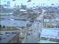 view gallery view galleryE20.4 km |  wbay skycam wbay skycam
in Web Cameras A skycam of Manitowoc, WI posted by: really I'm not lost location: Wisconsin date approved: 08/22/2005 last visited: 05/08/2009 |
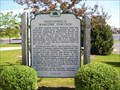 view gallery view galleryE20.6 km | Manitowoc's Maritime Heritage in Wisconsin Historical Markers Manitowoc's Maritime Heritage Marker in Manitowoc. posted by: frankhj location: Wisconsin date approved: 07/31/2007 last visited: 10/10/2016 |
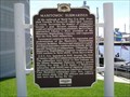 view gallery view galleryE20.6 km | Manitowoc Submarines in Wisconsin Historical Markers Manitowoc Submarines Marker in Manitowoc. The Wisconsin Maritime Museum here has a submarine on display. posted by: frankhj location: Wisconsin date approved: 07/31/2007 last visited: 10/10/2016 |
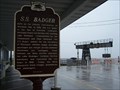 view gallery view galleryE21.1 km | S.S. Badger in Wisconsin Historical Markers Manitowoc and the Car Ferries posted by: jcak1979 location: Wisconsin date approved: 05/10/2006 last visited: 10/10/2016 |
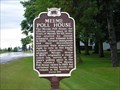 view gallery view galleryS21.6 km | Meeme Poll House in Wisconsin Historical Markers Meeme Poll House Marker in Meeme. posted by: frankhj location: Wisconsin date approved: 07/24/2007 last visited: never |
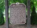 view gallery view gallerySW23 km | New Holstein in Wisconsin Historical Markers New Holstein Marker in New Holstein. posted by: frankhj location: Wisconsin date approved: 07/24/2007 last visited: never |
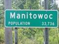 view gallery view galleryE23.3 km |  Manitowoc, WI, USA Manitowoc, WI, USA
in Population Signs The city of Manitowoc is the county seat of Manitowoc County, WI, USA with a population of 33,736 according to the 2010 census. posted by: REUAHNESIE location: Wisconsin date approved: 09/03/2012 last visited: 08/11/2013 |
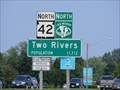 view gallery view galleryE23.5 km | Two Rivers, WI, USA in Population Signs The city of Two Rivers is in Manitowoc County, WI, USA with a population of 11,712 according to the 2010 census. posted by: REUAHNESIE location: Wisconsin date approved: 09/03/2012 last visited: never |
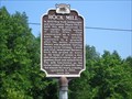 view gallery view gallery NE23.5 km NE23.5 km
| Rock Mill in Wisconsin Historical Markers Rock Mill Marker in Devils River Camper's Park near Maribel. The site has the old mill and a few other buildings. posted by: frankhj location: Wisconsin date approved: 07/24/2007 last visited: 08/04/2018 |
 view gallery view gallery N24.3 km N24.3 km
| Wisconsin's Dairy Industry in Wisconsin Historical Markers Wisconsin's Dairy Industry Marker near Denmark. posted by: frankhj location: Wisconsin date approved: 08/25/2007 last visited: 08/04/2018 |
 view gallery view galleryN24.6 km | Wisconsin's Maritime Industries in Wisconsin Historical Markers Wisconsin's Maritime Industries Marker near Denmark. posted by: frankhj location: Wisconsin date approved: 08/25/2007 last visited: 08/04/2018 |
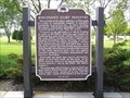
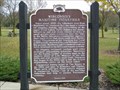
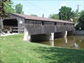 view gallery view galleryNE25.7 km |  Rockway Bridge Rockway Bridge
in Covered Bridges Here is a beautiful covered pedestrian bridge connecting Scenic Mishicot Park with Main Street Mishicot. posted by: peach107 location: Wisconsin date approved: 07/24/2012 last visited: 03/18/2015 |
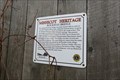
 view gallery view galleryNE25.7 km |  Mishicot Heritage, Rockway Bridge – Mishicot, WI Mishicot Heritage, Rockway Bridge – Mishicot, WI
in Signs of History This historical sign is attached to the covered pedestrian Rockway Bridge. It was sponsored by the Lions Club and the Mishicot Area Growth and Improvement Committee. posted by: wildernessmama location: Wisconsin date approved: 03/24/2015 last visited: never |
 view gallery view galleryNE25.7 km |  Mishicot Heritage, Rockway Bridge – Mishicot, WI Mishicot Heritage, Rockway Bridge – Mishicot, WI
in Lions Clubs International Markers This historical sign is attached to the covered pedestrian Rockway Bridge. It was sponsored by the Lions Club and the Mishicot Area Growth and Improvement Committee. posted by: wildernessmama location: Wisconsin date approved: 03/24/2015 last visited: never |
 view gallery view galleryE26.2 km | Ice Age Trail - Dunes Segment in Ice Age Trail IAT Dunes Segment posted by: The Troops location: Wisconsin date approved: 10/14/2012 last visited: 02/06/2016 |
 view gallery view galleryE26.4 km | 13th Street Water Tower - Two Rivers, WI, USA in Water Towers This is one of the twin towers supplying water to the city of Two Rivers, WI. posted by: REUAHNESIE location: Wisconsin date approved: 09/02/2012 last visited: 04/07/2011 |
|