 view gallery view gallery SE6.1 km SE6.1 km
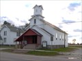
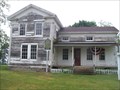
|   Gilford United Methodist Church Gilford United Methodist Church
in Michigan Historical Markers Located on the west side of Bradleyville Road, just north of West Gilford Road. Parking available at the church. posted by:  S5280ft S5280ft location: Michigan date approved: 10/17/2006 last visited: 01/12/2015 |
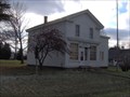
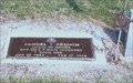 view gallery view gallerySE6.1 km |  Samuel S. French-Gilford, MI Samuel S. French-Gilford, MI
in Medal Of Honor Resting Places Civil War Medal of Honor Recipient for action at Fair Oaks, VA on May 31, 1862. He is buried in Gilford Cemetery, Gilford, MI. posted by:  Don.Morfe Don.Morfe location: Michigan date approved: 08/25/2018 last visited: 12/09/2021 |
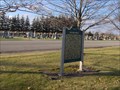
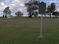 view gallery view gallery NE7.4 km NE7.4 km
| Indian Dave in Michigan Historical Markers Located at the entrance to Wisner Cemetery, on the north side of Bay City-Forrestville Road, between Bradleyville and Garner Roads. Plentiful parking at the cemetery, or the nearby township office. posted by: S5280ft location: Michigan date approved: 10/17/2006 last visited: 09/02/2016 |
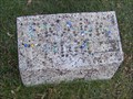 view gallery view galleryNE7.6 km |  Frank Thum - Wisner Cemetery Frank Thum - Wisner Cemetery
in Homemade Tombstones Marbles (not marble) spelling out a name set in concrete. posted by: S5280ft location: Michigan date approved: 10/28/2007 last visited: 06/04/2016 |
 view gallery view gallerySE14.8 km | Watrous General Store in Michigan Historical Markers Located on the southwest corner of Caro Road (M-81) and 2nd Street. Parking available on 2nd Street. posted by: S5280ft location: Michigan date approved: 12/05/2006 last visited: 01/12/2015 |
 view gallery view gallerySE14.8 km | Juniata House in Michigan Historical Markers Across the street from the other marker and is like the 3rd marker in a short stretch. Marked on side of road here. posted by: Historic Markers location: Michigan date approved: 06/06/2016 last visited: 06/07/2016 |
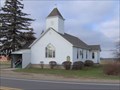
 view gallery view gallery S15 km S15 km
| Frankenhilf in Michigan Historical Markers Located on the east side of Van Buren between Sanilac (M-46) and Saginaw Roads (M-15), north of the church. Parking available at the church. posted by: S5280ft location: Michigan date approved: 12/05/2006 last visited: 03/17/2014 |
 view gallery view gallerySE15.1 km | Watrousville United Methodist Church in Michigan Historical Markers Located on the north side of Caro Road (M-81), 0.1 miles east of Ringle Road. Parking available in the parking lot. posted by: S5280ft location: Michigan date approved: 12/05/2006 last visited: 01/12/2015 |
 view gallery view gallery SW16.3 km SW16.3 km
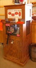
|  Johnson's Giant Pumpkin Farm Penny - Saginaw, MI Johnson's Giant Pumpkin Farm Penny - Saginaw, MI
in Penny Smashers Johnson's Giant Pumpkin Farm is located at 4715 N Portsmouth Rd., in Saginaw, Michigan posted by: DougandSandra location: Michigan date approved: 08/15/2016 last visited: 01/13/2021 |
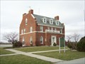
 view gallery view gallery NW16.4 km NW16.4 km
|  Hughes School, Bay City, Michigan Hughes School, Bay City, Michigan
in Civil Defense Fallout Shelters This shelter is located at 810 Langstaff St in Bay City posted by: EL1998P71 location: Michigan date approved: 09/08/2013 last visited: never |
![Image for Center Avenue [east end at Livingston Street]](https://img.geocaching.com/waymarking/small/ac087e07-21fc-4194-97f3-da076aff0db9.jpg) view gallery view gallery W16.7 km W16.7 km
| Center Avenue [east end at Livingston Street] in Michigan Historical Markers Located on the north side of Center Avenue at Livingston (but you probably guessed that from the title). Parking available at various expeditious cuisine cafés (fast food joints). posted by: S5280ft location: Michigan date approved: 01/14/2007 last visited: 06/04/2016 |
 view gallery view galleryNW16.9 km | Beet Sugar Industry in Michigan Historical Markers On the north side of Woodside Avenue where McDonnell Street T's in from the south. Plenty of parking at the Knight's of Columbus hall. posted by: S5280ft location: Michigan date approved: 07/22/2006 last visited: 03/17/2014 |
 view gallery view galleryNW16.9 km | Bay City Boating and Fishing Club in Michigan Historical Markers On the west side of Pine Street (which changes names to Weadock Highway, which then dead-ends at the power plant), north of the town of Essexville. It is a private yacht club. The only place to park is the road shoulder. Be careful. posted by: S5280ft location: Michigan date approved: 07/22/2006 last visited: 03/17/2014 |
 view gallery view galleryW18 km | Beet Sugar in Michigan Historical Markers Located in Veteran's Memorial Park on M-13 (River Road) along the Saginaw River, about 3.5 miles from I-75. Plentiful parking is available. posted by: S5280ft location: Michigan date approved: 01/14/2007 last visited: 11/05/2021 |
 view gallery view galleryW18.3 km | St. Stanislaus Kostka Roman Catholic Church in Michigan Historical Markers Located on the northeast corner of Grant and Kosciuszko Avenue. Parking available. posted by: S5280ft location: Michigan date approved: 01/14/2007 last visited: 01/07/2014 |
 view gallery view galleryW18.7 km | James Clements Memorial Airport in Michigan Historical Markers Located on River Road (M-13), about 2.2 miles south of Lafayette Avenue in Bay City. Parking is available. The administration building and marker are on airport property, within the security fence, but I would, by no means, call it high security. posted by: S5280ft location: Michigan date approved: 01/14/2007 last visited: 11/05/2021 |
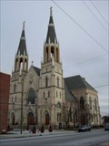
![Image for Trinity Church/Trinity Episcopal Church [of Bay City]](https://img.geocaching.com/waymarking/small/12d1f95c-557a-4474-9ecc-37b940250458.jpg) view gallery view galleryW18.8 km | Trinity Church/Trinity Episcopal Church [of Bay City] in Michigan Historical Markers Located on the north side of historic Center Avenue, between Grant and Van Buren Streets. Parking available. posted by: S5280ft location: Michigan date approved: 01/14/2007 last visited: 12/09/2021 |
![Image for St. Joseph Catholic Church [of Bay City]](https://img.geocaching.com/waymarking/small/c3c0117d-85fb-4798-8828-07c2c6c1dda5.jpg) view gallery view galleryW18.8 km | St. Joseph Catholic Church [of Bay City] in Michigan Historical Markers Located on the north side of 3rd Street, just east of Grant Street. Parking available. posted by: S5280ft location: Michigan date approved: 01/14/2007 last visited: 03/17/2014 |
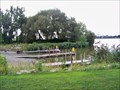
 view gallery view galleryNW18.8 km |  Independance Park - Bangor Township, Michign Independance Park - Bangor Township, Michign
in Boat Ramps This boat launch is located in Independence Park, just North of the Independence ridge in Bangor Townshp, Michigan posted by: GT.US location: Michigan date approved: 08/26/2010 last visited: never |
 view gallery view galleryNW18.8 km | Saginaw River Mouth - Boating Access Site - Bay City, Michigan in Boat Ramps This sall park is located near where the Saginaw River meets the Saginaw Bay. posted by: GT.US location: Michigan date approved: 08/26/2010 last visited: never |
![Image for First Presbyterian Church [of Bay City]](https://img.geocaching.com/waymarking/small/41060f7a-ba8e-4f5e-adaf-f4e74b3b895f.jpg) view gallery view galleryW18.8 km | First Presbyterian Church [of Bay City] in Michigan Historical Markers Located on the north side of historic Center Avenue, between Jackson and Van Buren Street. I think there is a presidential theme here. Parking available. posted by: S5280ft location: Michigan date approved: 01/14/2007 last visited: 12/09/2021 |
 view gallery view galleryW18.8 km |  Flamingo Motel - Bay City, MI Flamingo Motel - Bay City, MI
in Dixie Highway A classic motel sign.
posted by: Team Farkle 7 location: Michigan date approved: 11/29/2007 last visited: never |
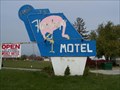 view gallery view galleryW18.8 km |  Flamingo Motel - Bay City, MI Flamingo Motel - Bay City, MI
in Neon Signs A classic motel sign. posted by: Team Farkle 7 location: Michigan date approved: 11/18/2007 last visited: never |
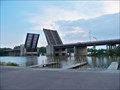 view gallery view galleryNW18.8 km |  Independence Bridge - Harry Truman Parkway - Saginaw, Michigan Independence Bridge - Harry Truman Parkway - Saginaw, Michigan
in Moving Bridges The Independence Bridge is a drawbridge located in Bay City, Michigan. It carries Truman Parkway over the Saginaw River and was opened in 1973. posted by: GT.US location: Michigan date approved: 08/24/2010 last visited: never |
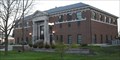 view gallery view galleryW19 km |  Thumb National Bank; Bay City, Michigan Thumb National Bank; Bay City, Michigan
in Carnegie Library Buildings Bay County, Michigan has a long history of library service. The onetime Bay City Carnegie Library is now in use as a bank. posted by: boatchick location: Michigan date approved: 12/10/2009 last visited: never |
|