 view gallery view gallery NE1 km NE1 km
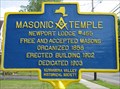
|   Masonic Temple Newport Lodge #455 Masonic Temple Newport Lodge #455
in New York Historical Markers Masonic Temple
Newport Lodge #455
Free and Accepted Masons
Organized 1858
Erected Building 1902
Dedicated 1903
Listed on the NYS and National Registers of Historic Places posted by:  OctaviaGraystone OctaviaGraystone location: New York date approved: 05/14/2013 last visited: never |
 view gallery view gallery NW1.3 km NW1.3 km
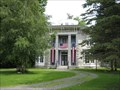
|  Yale-Cady Octagon House Yale-Cady Octagon House
in Octagon Buildings The Yale-Cady Octagon House built in 1850 from locally quarried limestone by Linus Yale, Sr., for his daughter, son-in-law and their children from Orson Fowler's book, The Octagon House, a Home for All. posted by: OctaviaGraystone location: New York date approved: 05/11/2013 last visited: never |
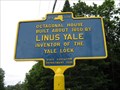 view gallery view galleryNW1.3 km | Octagonal House in New York Historical Markers Octagonal House
Built about 1850 by
Linus Yale
Inventor of the
Yale Lock
[New York] State Education Department
1932 posted by: OctaviaGraystone location: New York date approved: 05/14/2013 last visited: never |
 view gallery view gallery SE6.3 km SE6.3 km
|  Herkimer Diamond Mines - Herkimer, NY Herkimer Diamond Mines - Herkimer, NY
in Rock-Hounding Herkimer Diamond Mines is located North of Herkimer, NY at 4601 State Route 28. posted by:  mTn_biKer65 mTn_biKer65 location: New York date approved: 08/23/2013 last visited: never |
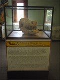 view gallery view gallerySE6.4 km |  Herkimer Diamond Mines - Randy's Room and Fossils - Herkimer, NY Herkimer Diamond Mines - Randy's Room and Fossils - Herkimer, NY
in Paleontology and Fossils Fossils display at Herkimer Diamond Mines located North of Herkimer, NY at 4601 State Route 28. posted by: mTn_biKer65 location: New York date approved: 09/02/2013 last visited: never |
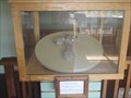 view gallery view gallerySE6.4 km |  Herkimer Diamond Mines - Gem + Mineral Shop - Herkimer, NY Herkimer Diamond Mines - Gem + Mineral Shop - Herkimer, NY
in Rock and Mineral Displays Herkimer Diamond Mines - Gem + Mineral Shop located North of Herkimer, NY at 4601 State Route 28. posted by: mTn_biKer65 location: New York date approved: 08/24/2013 last visited: never |
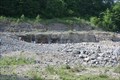 view gallery view gallerySE6.8 km |  Herkimer "Diamond" Mine - Herkimer, NY Herkimer "Diamond" Mine - Herkimer, NY
in Mines Quartz mine located in Herkimer, NY posted by: KDubs location: New York date approved: 09/27/2009 last visited: 07/28/2011 |
 view gallery view gallerySE6.8 km |  Astronomy "Sky Catcher" Lodge - Herkimer KOA - Herkimer, NY Astronomy "Sky Catcher" Lodge - Herkimer KOA - Herkimer, NY
in Astronomical Observatories Astronomy based lodge with its own observatory and telescope. Located North of Herkimer, NY at 4626 State Route 28. posted by: mTn_biKer65 location: New York date approved: 08/23/2013 last visited: never |
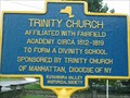 view gallery view gallerySE9.5 km | Trinity Church - Fairfield, NY in New York Historical Markers This is one of those rare 2-sided signs to tell us a bit of the history of Trinity Church! posted by: BarbershopDru location: New York date approved: 09/18/2008 last visited: never |
 view gallery view gallery SW13.8 km SW13.8 km
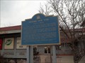
| Steuben Memorial in New York Historical Markers The first of two markers at this Westbound NYS thruway travel plaza. posted by: ChileHead location: New York date approved: 09/27/2008 last visited: 04/08/2014 |
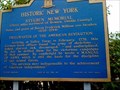
 view gallery view gallerySW13.8 km | Historic New York Utica Area in New York Historical Markers Second of two signs at this rest area on the westbound lane of the NYS Thruway. An identical sign exists at an eastbound rest stop about 20 miles west on the thruway. posted by: sagefemme location: New York date approved: 11/25/2011 last visited: 04/08/2014 |
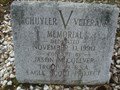 view gallery view gallerySW14 km |  Schuyler Veterans Memorial - Schuyler, NY Schuyler Veterans Memorial - Schuyler, NY
in Eagle Scout Project Sites Best access is from New York state highway 5. posted by: elyob location: New York date approved: 06/01/2016 last visited: never |
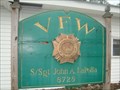 view gallery view gallerySW14 km |  Post 8728 S/Sgt John A. LaPolla Post - Schuyler, NY Post 8728 S/Sgt John A. LaPolla Post - Schuyler, NY
in VFW Posts Best access is from New York state highway 5. posted by: elyob location: New York date approved: 06/07/2016 last visited: never |
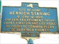 view gallery view gallerySW14.3 km | HENRICH STARING - Frankfort/Utica, New York in New York Historical Markers This plaque and another one related to Mr. Staring is located on Route 5 a few miles East of the city of Utica, New York. posted by: PTCrazy location: New York date approved: 05/26/2011 last visited: never |
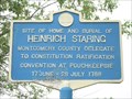 view gallery view gallerySW14.3 km | HEINRICH STARING - Frankfort/Utica, New York in New York Historical Markers This historical plaque along with another one relating to Mr. Staring is located on Route 5, a few miles East of the city of Utica, New York. posted by: PTCrazy location: New York date approved: 05/26/2011 last visited: never |
 view gallery view gallery S15 km S15 km
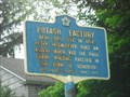
| POTASH FACTORY - Frankfort, New York in New York Historical Markers This historical plaque is located on Route 5, a few miles East of the city of Utica, New York. posted by: PTCrazy location: New York date approved: 05/26/2011 last visited: never |
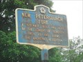 view gallery view galleryS15 km | NEW PETERSBURGH FORT - Frankfort, New York in New York Historical Markers This historical plaque is located on Route 5, a few miles East of the city of Utica, New York. posted by: PTCrazy location: New York date approved: 05/26/2011 last visited: never |
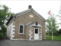 view gallery view galleryS16.4 km |  Schuyler District No. 3 Fire House - Schuyler District No. 3 Fire House -
in Cobblestone Buildings This cobblestone building served the Schuyler area as a fire house for many years, until recently, when a new firehouse was built next to it. posted by: PTCrazy location: New York date approved: 05/23/2011 last visited: 06/01/2016 |
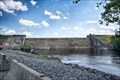 view gallery view galleryNW16.6 km |  Hinckley Reservoir Dam - Hinckley, New York Hinckley Reservoir Dam - Hinckley, New York
in Water Dams Built across the West Canada Creek near the village of Hinckley. The dam was constructed by the State of New York and completed in 1915 for the purpose of supplying water to the enlarged canal. posted by: nomadwillie location: New York date approved: 12/14/2022 last visited: never |
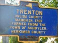 view gallery view galleryNW17.2 km | TRENTON - Barneveld, New York in New York Historical Markers This historical plaque is located on Mappa Avenue, near the Village of Barneveld, New York. posted by: PTCrazy location: New York date approved: 09/06/2009 last visited: never |
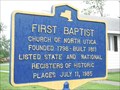 view gallery view gallerySW17.2 km | FIRST BAPTIST - Utica, New York in New York Historical Markers This historical plaque is located along Route 5 in North Utica, New York. posted by: PTCrazy location: New York date approved: 05/26/2011 last visited: never |
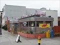 view gallery view galleryS17.4 km |  Empire Diner, Herkimer, New York, 13350 Empire Diner, Herkimer, New York, 13350
in Dining Car Restaurants Justifiably claiming to be the "Best Breakfast in the Mohawk Valley". posted by: Andy Too location: New York date approved: 09/17/2008 last visited: 03/26/2010 |
 view gallery view galleryS17.7 km |  WalMart- Herkimer, NY WalMart- Herkimer, NY
in WAL*MART Stores This WalMart was in New Yore just had to stop. posted by: barkertrackers location: New York date approved: 08/01/2007 last visited: 06/01/2016 |
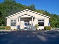 view gallery view galleryNW18 km |  Barneveld, New York 13304 Barneveld, New York 13304
in U.S. Post Offices Barneveld is a small community located in Oneida County, and is located in the Leatherstocking region of New York State. posted by: PTCrazy location: New York date approved: 09/14/2009 last visited: never |
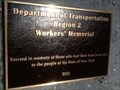 view gallery view gallerySW18.5 km |  State Workers' Memorial - Utica, New York State Workers' Memorial - Utica, New York
in Citizen Memorials Harbor Lock Road Park & Ride, off of North Genesee Street posted by: elyob location: New York date approved: 07/12/2018 last visited: never |
|