 view gallery view gallery SE2.4 km SE2.4 km
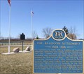
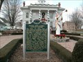
|   The Baldoon Settlement The Baldoon Settlement
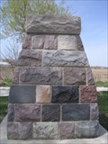
in Ontario Provincial Plaques This plaque marks the short-lived Baldoon Settlement established in 1804 by 15 families of Scottish immigrants posted by:  Hard Oiler Hard Oiler location: Ontario, Canada date approved: 03/19/2006 last visited: 05/11/2015 |
 SE2.4 km |  Baldoon Mystery Baldoon Mystery
in Weird Story Locations The coordinates will take you to plaques marking the site of the Baldoon Mystery, a story of supernatural events which took place between 1830 and 1840. posted by: Hard Oiler location: Ontario, Canada date approved: 08/16/2005 last visited: 05/11/2015 |
 view gallery view gallery SW2.7 km SW2.7 km
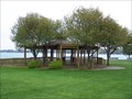
|  June E. Crocker Memorial Gazebo - Algonac, Michigan June E. Crocker Memorial Gazebo - Algonac, Michigan
in Gazebos The June E. Crocker Memorial Gazebo was dedicated on June 27, 1991. It is located at the northeast end of the river front park just north of the Historical Museum. posted by:  Leader1 Leader1 location: Michigan date approved: 06/11/2010 last visited: 03/08/2023 |
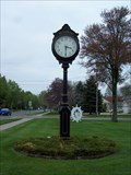 view gallery view gallerySW2.9 km |  Algonac Town Clock - Algonac, Michigan Algonac Town Clock - Algonac, Michigan
in Town Clocks Town Clock in Algonac, MI Along St. Clair River Drive. posted by: Leader1 location: Michigan date approved: 06/12/2010 last visited: 03/08/2023 |
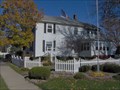 view gallery view gallerySW2.9 km |  Clay Township Library Clay Township Library
in Michigan Historical Markers It is now the location of the Algonac-Clay [Township] Historical Society. Located on the river side of St. Clair River Road at the end of Clay Street. Parking available on site. posted by: S5280ft location: Michigan date approved: 11/02/2006 last visited: 03/08/2023 |
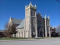
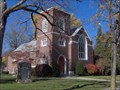 view gallery view gallerySW2.9 km | Saint Andrew's Parish/Saint Andrew's Church in Michigan Historical Markers The Church building is now a private residence and the marker was moved to the above location on the southwest side of the Museum of Local History at 1240 St. Clair River Road. The Church building is up the street at 1507 St. Clair River Road. posted by: S5280ft location: Michigan date approved: 11/01/2006 last visited: 03/08/2023 |
 view gallery view gallerySW3.2 km | Water Speed Capital in Michigan Historical Markers Located in the City of Algonac Park between St.Clair River Road and the St. Clair River. Parking available in many places along the park. posted by: S5280ft location: Michigan date approved: 11/02/2006 last visited: 01/14/2023 |
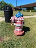 view gallery view gallerySW3.2 km |  Old Glory - Algonac, MI Old Glory - Algonac, MI
in Painted Hydrants Painted hydrant located along St. Clair Rive Drive in Algonac, Michigan with a few of the St. Clair River. posted by: bobfrapples8 location: Michigan date approved: 04/13/2023 last visited: never |
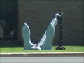 view gallery view gallerySW3.4 km |  Seafarer's Anchor Seafarer's Anchor
in Anchors Anchor standing guard at the Seafarer's building in Algonac. posted by: paldog0603 location: Michigan date approved: 08/25/2009 last visited: 06/02/2015 |
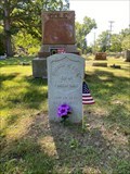 view gallery view gallery W3.5 km W3.5 km
|  Algonac Civil War veteran honored in grave dedication - Algonac, MI Algonac Civil War veteran honored in grave dedication - Algonac, MI
in News Article Locations News story about a Civil War veteran from Michigan who served under General Custer at Gettysburg getting a proper gravestone. posted by: bobfrapples8 location: Michigan date approved: 03/08/2023 last visited: never |
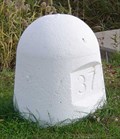
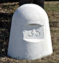 view gallery view gallery N3.5 km N3.5 km
|  24U3270 - MMMCCLXX - IBC Marker 35 24U3270 - MMMCCLXX - IBC Marker 35
in Canadian Benchmarks IBC Marker 35 is one of the land based International Boundary Commission markers used to define the US/Canada border along the St Clair River between Michigan and Ontario posted by: Hard Oiler location: Ontario, Canada date approved: 03/19/2006 last visited: 06/10/2020 |
 view gallery view gallerySW6.4 km | Stewart Farm/Memoir of Aura Stewart in Michigan Historical Markers Located on the south side of Stewart Road east of Golf Course Road, on beautiful Harsons Island. Take the ferry to get there. You will have to park beside the road to visit the marker. posted by: S5280ft location: Michigan date approved: 11/02/2006 last visited: 01/06/2014 |
 view gallery view galleryW6.8 km | Harsen House in Michigan Historical Markers This private home is located on the west side of Golf Course Road on beautiful Harsons Island. Take the ferry to get there. You're on your own for parking. posted by: S5280ft location: Michigan date approved: 11/02/2006 last visited: 01/06/2014 |
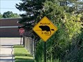 view gallery view galleryW6.9 km |  Muskrat Crossing - Clay Township, MI Muskrat Crossing - Clay Township, MI
in Uncommon Crossing Signs Muskrat crossing located in Clay Township, Michigan. posted by: bobfrapples8 location: Michigan date approved: 03/08/2023 last visited: never |
 view gallery view galleryW8.5 km |  St. John's Marsh Time Capsules St. John's Marsh Time Capsules
in Time Capsules This site contains not one but TWO time capsules. posted by: Team--B location: Michigan date approved: 04/23/2010 last visited: 01/14/2023 |
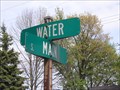 view gallery view galleryN8.7 km |  Corner Of Water & Main - Marine City, Mi. Corner Of Water & Main - Marine City, Mi.
in Interesting Intersection Names Seen while in Marine City, Mi. posted by: Team--B location: Michigan date approved: 05/18/2010 last visited: 05/05/2013 |
 view gallery view galleryN8.9 km | Holy Cross Parish in Michigan Historical Markers Located on South Water Street between South Main and Bridge Streets. A huge parking lot available next to the St. Clair River. posted by: S5280ft location: Michigan date approved: 10/31/2006 last visited: 03/08/2023 |
 view gallery view galleryN9.2 km | Newport Academy in Michigan Historical Markers Located on the corner of East St. Clair and South Main Streets. Streetside parking available. posted by: S5280ft location: Michigan date approved: 10/31/2006 last visited: 06/29/2022 |
 view gallery view galleryN9.2 km | David and Laura Lester House in Michigan Historical Markers This site is just across the street from the Marine City Historical Museum. posted by: Rattrak location: Michigan date approved: 01/09/2010 last visited: 06/29/2022 |
 view gallery view galleryN9.3 km |  Peche Island Rear Range Light - Marine City, MI. Peche Island Rear Range Light - Marine City, MI.
in Coastal Lighthouses Located in Marine City, Michigan, on Water Street, on the banks of the St. Clair River. posted by: Team--B location: Michigan date approved: 03/01/2011 last visited: 10/09/2016 |
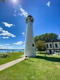 view gallery view galleryN9.3 km |  Peche Island Rear Range Light - Marine City, MI Peche Island Rear Range Light - Marine City, MI
in Wikipedia Entries Pêche Island Rear Light is located in Marine City, Michigan. posted by: bobfrapples8 location: Michigan date approved: 01/15/2023 last visited: never |
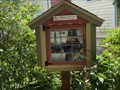 view gallery view galleryN9.3 km |  LFL #34310- Marine City, MI LFL #34310- Marine City, MI
in Free Community Book Exchanges LFL located in the front yard of a private residence in Marine City, Michigan. posted by: bobfrapples8 location: Michigan date approved: 06/29/2022 last visited: never |
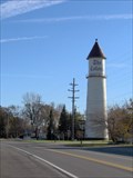 view gallery view galleryW9.5 km | Colony Tower in Michigan Historical Markers Located on the southwest side of M-29 (Pointe Tremble/Dyke Road). There is no legal parking nearby, except within the subdivision. My suggestion: be quick. posted by: S5280ft location: Michigan date approved: 11/02/2006 last visited: 01/14/2023 |
 view gallery view galleryW9.5 km |  The Colony Watertower, Clay Township, MI, U.S.A. The Colony Watertower, Clay Township, MI, U.S.A.
in Water Towers Located on the southwest side of M-29 (Pointe Tremble/Dyke Road). There is no legal parking nearby, except within the subdivision. My suggestion: be quick. posted by: S5280ft location: Michigan date approved: 11/27/2006 last visited: 01/14/2023 |
 view gallery view galleryN9.5 km | 24U3265 - MMMCCLXV - IBC Marker 37 in Canadian Benchmarks IBC Marker 37 is one of the land based International Boundary Commission markers used to define the US/Canada border along the St Clair River between Michigan and Ontario posted by: Hard Oiler location: Ontario, Canada date approved: 11/14/2005 last visited: 05/11/2015 |
|