 view gallery view gallery S18 km S18 km
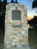
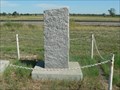
|   Mormon Pioneer Camp - Bridgeport, Nebraska Mormon Pioneer Camp - Bridgeport, Nebraska
in Wagon Roads and Trails Historical marker located north of Bridgeport along US 385 commemorating a camp along the Mormon Trail. posted by:  BruceS BruceS location: Nebraska date approved: 08/23/2007 last visited: 06/19/2016 |
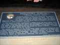
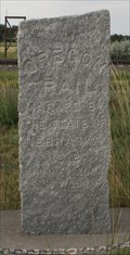
 view gallery view galleryS18 km |  No. 79 - Mormon Pioneer Camp No. 79 - Mormon Pioneer Camp
in Nebraska Historical Markers Historical marker located north of Bridgeport along US 385 commemorating a camp along the Mormon Trail. posted by: BruceS location: Nebraska date approved: 08/20/2007 last visited: 06/19/2016 |
 view gallery view galleryS18.7 km | Bridgeport, Nebraska - "Trail City, USA" in Nebraska Historical Markers Nebraska historical marker commemorating Bridgeport and the many wagon trails which passed through the area. posted by: BruceS location: Nebraska date approved: 08/20/2007 last visited: 11/09/2019 |
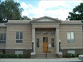
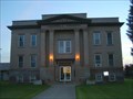 view gallery view galleryS19.3 km |  Morrill County Courthouse - Bridgeport, Nebraska Morrill County Courthouse - Bridgeport, Nebraska
in U.S. National Register of Historic Places Historic county courthouse located in Bridgeport, Nebraska. posted by: BruceS location: Nebraska date approved: 08/20/2007 last visited: 06/19/2016 |
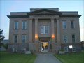 view gallery view galleryS19.3 km |  Morrill County Courthouse - Bridgeport, Nebraska Morrill County Courthouse - Bridgeport, Nebraska
in Courthouses Historic county courthouse located in Bridgeport, Nebraska. posted by: BruceS location: Nebraska date approved: 08/21/2007 last visited: 06/19/2016 |
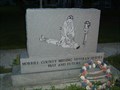 view gallery view galleryS19.3 km |  Morrill County Veterans Memorial - Bridgeport, Nebraska Morrill County Veterans Memorial - Bridgeport, Nebraska
in Non-Specific Veteran Memorials Veterans memorial on the grounds of the Morrill County courthouse in Bridgeport, Nebraska. posted by: BruceS location: Nebraska date approved: 08/21/2007 last visited: 06/19/2016 |
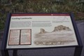 view gallery view galleryS19.5 km | Guiding Landmarks -- US 26 W of Broadwater NE in Nebraska Historical Markers A Mormon Pioneer Trail historic marker on the US 26 west of Broadwater NE posted by:  Benchmark Blasterz Benchmark Blasterz location: Nebraska date approved: 02/06/2014 last visited: 08/07/2013 |
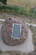 view gallery view galleryS20.6 km |  Camp Clarke and Bridge DAR Marker -- Bridgeport, Morrill Co., NE, USA Camp Clarke and Bridge DAR Marker -- Bridgeport, Morrill Co., NE, USA
in Daughters of the American Revolution A small DAR plaque at the former site of Camp Clarke in Morrill County NE USA posted by: Benchmark Blasterz location: Nebraska date approved: 05/08/2023 last visited: 05/09/2023 |
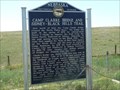 view gallery view galleryS20.6 km | Camp Clarke Bridge And Sidney-Black Hills Trail in Nebraska Historical Markers This 1876 Bridge was built to improve the trail from the Union Pacific Railroad at Sidney, NE to the gold mining towns in the Black Hills. posted by: plainsdrifter358 location: Nebraska date approved: 05/13/2008 last visited: 11/09/2019 |
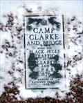 view gallery view galleryS20.6 km | Camp Clarke And Pony Express in Nebraska Historical Markers Quick Turnout West of Bridgeport Nebraska off of State Highway 92. posted by: StarBrand location: Nebraska date approved: 06/06/2006 last visited: 11/09/2019 |
 view gallery view gallery SW23.3 km SW23.3 km
| Mormon Pioneer Trail - Halfway to Zion in Nebraska Historical Markers Chimney Rock was the psychological halfway on the long trek to the Valley of the Great Salt Lake. From this site, you will have a grand view of Chimney Rock and the North Platte River Valley on the Mormon and Oregon Trails. posted by: plainsdrifter358 location: Nebraska date approved: 05/13/2008 last visited: 07/28/2016 |
 view gallery view gallerySW25.7 km | Chimney Rock in Nebraska Historical Markers Landmark for early mountain men and later to pioneers and settlers rising 470 feet skyward along the Great Plate River Valley Road. posted by: plainsdrifter358 location: Nebraska date approved: 05/13/2008 last visited: 04/11/2023 |
 view gallery view gallerySW25.7 km |  Chimney Rock Statiion Chimney Rock Statiion
in Pony Express Monuments Chimney Rock Pony Express Station near Bayard, NE posted by: plainsdrifter358 location: Nebraska date approved: 05/15/2008 last visited: 11/09/2019 |
 view gallery view gallerySW25.7 km |  S 51* 58' W -- NE 92 nr Chimney Rock S 51* 58' W -- NE 92 nr Chimney Rock
in Permanent Geographic Coordinates A 1912 Nebraska Historic marker with a set of bearing coordinates for a nearby Oregon Trail landmark. posted by: Benchmark Blasterz location: Nebraska date approved: 02/06/2014 last visited: 11/09/2019 |
 view gallery view gallerySW25.7 km | Oregon Trail along North PLatte River near Bayard, NE in Wagon Roads and Trails Oregon Trail marker along the Great Platte River Road between Bridgeport and Scottsbluff near Bayard, NE posted by: plainsdrifter358 location: Nebraska date approved: 05/14/2008 last visited: 11/09/2019 |
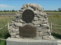
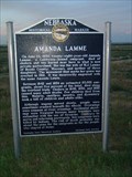 view gallery view galleryS26.1 km | Amanda Lamme in Nebraska Historical Markers Historical marker commemorating the perils facing pioneers along the wagon trails. Marker is located along US 385 south of Brigdeport. posted by: BruceS location: Nebraska date approved: 08/20/2007 last visited: 04/12/2023 |
 view gallery view gallerySW26.2 km | Chimney Rock in Pony Express Monuments Chimney Rock was the most mentioned landmark in journals of Oregon Trail followers, and was a station for the Pony Express. posted by:  Dew Crew Dew Crew location: Nebraska date approved: 04/30/2006 last visited: 02/15/2020 |
 view gallery view gallerySW26.2 km |  Chimney Rock Chimney Rock
in NPS Passport Cancellation Stations Located in Western Nebraska. posted by: Dew Crew location: Nebraska date approved: 05/01/2006 last visited: 06/01/2019 |
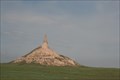 view gallery view gallerySW26.4 km | Chimney Rock National Historic Site - Bayard, Nebraska in U.S. National Register of Historic Places Chimney Rock National Historic Site is located along the Oregon, California, Mormon, and Pony Express National Historic Trails. posted by: gparkes location: Nebraska date approved: 01/31/2010 last visited: 04/11/2023 |
 view gallery view gallerySW26.4 km |  Chimney Rock - Western Trails Scenic & Historic Byway - South Bayard, Nebraska Chimney Rock - Western Trails Scenic & Historic Byway - South Bayard, Nebraska
in National Scenic Byways Western Trails Scenic & Historic Byway begins in Ogallala and travels for 144 miles northwest to the Wyoming border. Consisting of both scenic and historic features, this route follows along the route of pioneers in the 1800's. posted by: gparkes location: Nebraska date approved: 01/31/2010 last visited: 04/11/2023 |
 view gallery view gallerySW27.4 km |  Chimney Rock National Historic Site - Bayard NE Chimney Rock National Historic Site - Bayard NE
in Wikipedia Entries Chimney Rock is a prominent geological rock formation in Morrill County in western Nebraska. Rising nearly 300 feet (91 m) above the surrounding North Platte River valley, the peak of Chimney Rock is 4,228 feet (1,289 m) above sea level. posted by: Don.Morfe location: Nebraska date approved: 12/18/2022 last visited: 04/11/2023 |
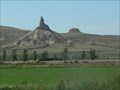
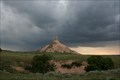
 view gallery view galleryS27.4 km | Courthouse and Jailhouse Rocks in Nebraska Historical Markers The marker stands by Rt 88 at the side road leading to two famous natural landmarks. posted by: NevaP location: Nebraska date approved: 06/12/2008 last visited: 02/15/2020 |
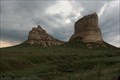 view gallery view galleryS27.4 km | Courthouse and Jail House Rocks - Bridgeport, Nebraska in U.S. National Register of Historic Places Courthouse and Jailhouse Rocks are located along the Oregon, California, Mormon, and Pony Express National Historic Trails. They provided natural "waymarks" to the historic traveler along their journey. posted by: gparkes location: Nebraska date approved: 01/31/2010 last visited: 04/11/2023 |
 view gallery view gallery NE33.2 km NE33.2 km
|  Alliance, Nebraska Alliance, Nebraska
in City and Town Halls The Municipal Building houses the offices for the City of Alliance. posted by: BruceS location: Nebraska date approved: 08/21/2007 last visited: never |
 view gallery view galleryNE33.2 km |  Carnegie Art Center - Alliance, Nebraska Carnegie Art Center - Alliance, Nebraska
in Carnegie Library Buildings The Carnegie Art Center is housed in the former Alliance Carnegie Library in Alliance, Nebraska. posted by: BruceS location: Nebraska date approved: 08/21/2007 last visited: never |
|