 view gallery view gallery N17.7 km N17.7 km
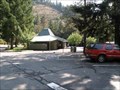
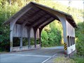
|   Collier Tunnel Safety Rest Area - U.S. Hwy. 199 Collier Tunnel Safety Rest Area - U.S. Hwy. 199
in Highway Rest Areas U.S. Hwy. 199 rest area between Crescent City, CA and Cave Junction, OR. posted by:  Volcanoguy Volcanoguy location: California date approved: 01/08/2013 last visited: 09/25/2012 |
 view gallery view gallery W18.8 km W18.8 km
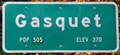
|  Gasquet, California ~ Population 350 Gasquet, California ~ Population 350
in Population Signs This combination Population/Elevation Sign is on the north side of US Highway 199 as you enter Gasquet from the east. posted by: brwhiz location: California date approved: 12/13/2012 last visited: never |
 view gallery view galleryW18.8 km |  Gasquet, California ~ Elevation 370 Feet Gasquet, California ~ Elevation 370 Feet
in Elevation Signs This combination Population/Elevation Sign is on the north side of US Highway 199 as you enter Gasquet from the east. posted by: brwhiz location: California date approved: 12/13/2012 last visited: never |
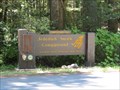
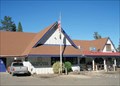
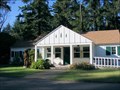 view gallery view galleryW19 km |  Smith River National Recreation Area Headquarters - Gasquet, CA Smith River National Recreation Area Headquarters - Gasquet, CA
in Ranger Stations The 300-acre Smith River National Recreation area was formed in 1990 and lies in extreme northern California along the Oregon border. There are five camp grounds, 65 miles of trails, and trophy clsss fishing on the Smith River. posted by:  silverquill silverquill location: California date approved: 02/18/2009 last visited: never |
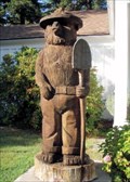 view gallery view galleryW19 km |  Smokey at Smith River National Recreation Area Headquarters - Gasquet, CA Smokey at Smith River National Recreation Area Headquarters - Gasquet, CA
in Outside Wooden Display Carvings This hand-carved Smokey stands beside the Smith River National Recreation Area Headquarters in Gasquet, California, on Route 199, The Redwood Highway. posted by: silverquill location: California date approved: 02/19/2009 last visited: 09/23/2012 |
 view gallery view galleryW19 km |  Smokey at Smith River National Recreation Area Headquarters - Gasquet, CA Smokey at Smith River National Recreation Area Headquarters - Gasquet, CA
in Smokey Bear Sign Sightings This hand-carved Smokey stands beside the Smith River National Recreation Area Headquarters in Gasquet, California, on Route 199, The Redwood Highway. posted by: silverquill location: California date approved: 02/18/2009 last visited: 09/23/2012 |
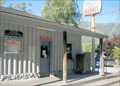 view gallery view galleryW19.3 km |  Gasquet, CA 95543 Gasquet, CA 95543
in U.S. Post Offices This is the post office for the roadside town of Gasquet, California. It shares a building with a store and the fire department on Route 199 between the Oregon Caves National Monument and the Route 101 on the coast. posted by: silverquill location: California date approved: 10/27/2008 last visited: 11/17/2011 |
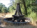 view gallery view galleryW19.3 km |  Stone Eiffel Tower - Gasquet, CA Stone Eiffel Tower - Gasquet, CA
in Realistic Object Sculptures This is a random roadside sculpture along the scenic Redwood Highway (Rt. 199) near the post office in tiny Gasquet, California. There may have been a business, home or other building here at one time, or it may be a random placement. posted by: silverquill location: California date approved: 02/18/2009 last visited: 07/01/2010 |
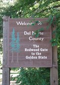 view gallery view galleryN20 km |  The Redwood Gate to the Golden State - Del Norte County, CA The Redwood Gate to the Golden State - Del Norte County, CA
in Welcome Signs This sign is seen entering Del Norte County from the northeast on Highway 199, the Redwood Highway, that connects Grants Pass, Oregon, to the Crescent City, California, on the Pacific Coast. posted by: silverquill location: California date approved: 02/18/2009 last visited: 08/29/2013 |
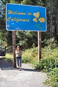 view gallery view galleryN20.8 km |  Welcome To California Ca/Or Border on US199 Welcome To California Ca/Or Border on US199
in Border Crossings The California welcome sign about .1 mile south of the OR/CA border on US highway 199 Between Grants Pass, Oregon and Crescent City, California. posted by: HeyRob4449 location: California date approved: 10/20/2007 last visited: 09/23/2012 |
 view gallery view galleryW26.2 km |  Howland Hill Road Howland Hill Road
in Covered Bridges Modern covered structure built in the 1970s to replace a one-lane bridge over Sheep Pen Creek on a great backroad from Highway 199 over the Smith River through the redwoods into Crescent City. posted by: Darmok and Jalad location: California date approved: 07/14/2007 last visited: 06/13/2019 |
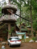 view gallery view galleryN27.2 km |  Out 'n' About Treesort and Treehouse Institute Out 'n' About Treesort and Treehouse Institute
in Treehouses A group of 10 treehouses that are rented out as a treehouse bread and breakfast in Takilma Oregon. posted by: GeoHueb location: Oregon date approved: 06/28/2008 last visited: never |
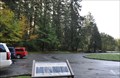 view gallery view galleryW28.2 km |  Mixed Evergreen Forests Mixed Evergreen Forests
in Flora and Fauna Information Signs This Flora and Fauna Sign is located in a turnout on the east side of US Highway 199 in the Jedediah Smith Redwood State Park northeast of Crescent City, California. posted by: brwhiz location: California date approved: 12/14/2012 last visited: never |
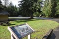 view gallery view galleryW28.3 km | Redwood Country Wildlife in Flora and Fauna Information Signs This Flora and Fauna Sign is located in a turnout on the east side of US Highway 199 in the Jedediah Smith Redwood State Park northeast of Crescent City, California. posted by: brwhiz location: California date approved: 12/14/2012 last visited: never |
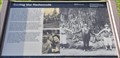 view gallery view galleryW28.3 km |  Saving the Redwoods Saving the Redwoods
in Signs of History This historical marker is located in a turnout on the east side of US Highway 199 in the Jedediah Smith Redwood State Park about nine miles northeast of Crescent City, California. posted by: brwhiz location: California date approved: 12/13/2012 last visited: never |
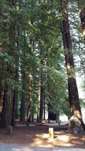
 view gallery view galleryW28.5 km |  Jedediah Smith Redwood SP - California Jedediah Smith Redwood SP - California
in State/Provincial Parks Jedediah Smith Redwood SP was established in 1929. This predominately old growth coast redwoods park is bisected by the last major free flowing river in California, the Smith River. The park protects 10,000 acres of primeval redwood groves. posted by: DougK location: California date approved: 07/17/2013 last visited: 06/13/2019 |
 view gallery view galleryW28.5 km |  LARGEST - World War II Memorial in the United States LARGEST - World War II Memorial in the United States
in Superlatives Spreading out over 5000 acres, the National Tribute Grove, dedicated in 1949, is the largest World War II memorial in the United States. posted by: NW_history_buff location: California date approved: 09/07/2018 last visited: never |
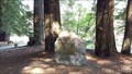 view gallery view galleryW28.5 km |  National Tribute Grove - Jedediah State Park, CA National Tribute Grove - Jedediah State Park, CA
in World War II Memorials / Monuments Spreading out over 5000 acres, the National Tribute Grove, dedicated in 1949, is the largest World War II memorial in the United States. posted by: NW_history_buff location: California date approved: 09/08/2018 last visited: never |
 view gallery view galleryN28.8 km |  Giant Fly - O'Brien, OR Giant Fly - O'Brien, OR
in Roadside Attractions Where would you find a giant fly? On top of the restrooms, of course! Be sure to ask for the keys at the store, and don't be surprised to be given a large fly swatter. Found at the roadside stop of O'Brien, Oregon, on the Redwood Highway. posted by: silverquill location: Oregon date approved: 02/17/2009 last visited: 08/07/2015 |
 view gallery view galleryN28.8 km |  Giant Fly - O'Brien, OR Giant Fly - O'Brien, OR
in Insect Sculptures Where would you find a giant fly? On top of the restrooms, of course! Be sure to ask for the keys at the store, and don't be surprised to be given a large fly swatter. Found at the roadside stop of O'Brien, Oregon, on the Redwood Highway. posted by: silverquill location: Oregon date approved: 02/18/2009 last visited: 08/08/2015 |
 view gallery view galleryN28.8 km |  O'Brien Store Ice Cream - O'brien, OR O'Brien Store Ice Cream - O'brien, OR
in Ice Cream Parlors When traveling the Redwood Highway, a stop at O'Brien for ice cream is the perfect thing. An old caboose from the McLoud River Railrood sits next to the store and post office, with walk-up service only. posted by: silverquill location: Oregon date approved: 02/18/2009 last visited: 08/07/2015 |
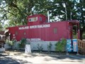 view gallery view galleryN28.8 km |  McCloud River Railroad Caboose MR 103 - O'Brien, OR McCloud River Railroad Caboose MR 103 - O'Brien, OR
in Train Cabooses This retired caboose from the old McCloud River Railroad, is now an ice cream stand at the store and post office in the roadside town of O'Brien, Oregon, on the scenic Redwood Highway. posted by: silverquill location: Oregon date approved: 02/18/2009 last visited: 08/07/2015 |
 view gallery view galleryN28.8 km | O'Brien, OR 97534 in U.S. Post Offices This is the post office for O'Brien, Oregon. Located on Rte. 199 between the Oregon Caves National Monument and the California coast, O'Brien invites a stop with its unique ice cream stand and the general store which houses this post office. posted by: silverquill location: Oregon date approved: 10/27/2008 last visited: 11/17/2011 |
 view gallery view galleryN28.8 km |  Unpainted Cigar Store Indian - O'Brien, OR Unpainted Cigar Store Indian - O'Brien, OR
in Cigar Store Indians This unpainted cigar store Indian, along with a miner, stand out on the porch of the general store and post office at the roadside town of O'Brien, Oregon, on the scenic Redwood Highway in the heart of Oregon's old gold fever country. posted by: silverquill location: Oregon date approved: 02/21/2009 last visited: never |
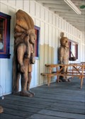 view gallery view galleryN28.8 km | Cigar Store Indian & Miner - O'Brien, OR in Outside Wooden Display Carvings This unpainted cigar store Indian and old miner, stand out on the porch of the general store and post office at the roadside town of O'Brien, Oregon, on the scenic Redwood Highway in the heart of Oregon's old gold fever country. posted by: silverquill location: Oregon date approved: 02/19/2009 last visited: never |
|