 view gallery view gallery NW10 km NW10 km
|   Howland Hill Road Howland Hill Road
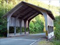
in Covered Bridges Modern covered structure built in the 1970s to replace a one-lane bridge over Sheep Pen Creek on a great backroad from Highway 199 over the Smith River through the redwoods into Crescent City. posted by:  Darmok and Jalad Darmok and Jalad location: California date approved: 07/14/2007 last visited: 06/13/2019 |
 view gallery view gallery N11.9 km N11.9 km
|  Gasquet, California ~ Population 350 Gasquet, California ~ Population 350
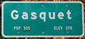
in Population Signs This combination Population/Elevation Sign is on the north side of US Highway 199 as you enter Gasquet from the east. posted by: brwhiz location: California date approved: 12/13/2012 last visited: never |
 view gallery view galleryN11.9 km |  Gasquet, California ~ Elevation 370 Feet Gasquet, California ~ Elevation 370 Feet
in Elevation Signs This combination Population/Elevation Sign is on the north side of US Highway 199 as you enter Gasquet from the east. posted by: brwhiz location: California date approved: 12/13/2012 last visited: never |
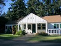 view gallery view galleryN11.9 km |  Smith River National Recreation Area Headquarters - Gasquet, CA Smith River National Recreation Area Headquarters - Gasquet, CA
in Ranger Stations The 300-acre Smith River National Recreation area was formed in 1990 and lies in extreme northern California along the Oregon border. There are five camp grounds, 65 miles of trails, and trophy clsss fishing on the Smith River. posted by:  silverquill silverquill location: California date approved: 02/18/2009 last visited: never |
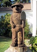 view gallery view galleryN11.9 km |  Smokey at Smith River National Recreation Area Headquarters - Gasquet, CA Smokey at Smith River National Recreation Area Headquarters - Gasquet, CA
in Outside Wooden Display Carvings This hand-carved Smokey stands beside the Smith River National Recreation Area Headquarters in Gasquet, California, on Route 199, The Redwood Highway. posted by: silverquill location: California date approved: 02/19/2009 last visited: 09/23/2012 |
 view gallery view galleryN11.9 km |  Smokey at Smith River National Recreation Area Headquarters - Gasquet, CA Smokey at Smith River National Recreation Area Headquarters - Gasquet, CA
in Smokey Bear Sign Sightings This hand-carved Smokey stands beside the Smith River National Recreation Area Headquarters in Gasquet, California, on Route 199, The Redwood Highway. posted by: silverquill location: California date approved: 02/18/2009 last visited: 09/23/2012 |
 view gallery view galleryN12.1 km |  Gasquet, CA 95543 Gasquet, CA 95543
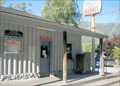
in U.S. Post Offices This is the post office for the roadside town of Gasquet, California. It shares a building with a store and the fire department on Route 199 between the Oregon Caves National Monument and the Route 101 on the coast. posted by: silverquill location: California date approved: 10/27/2008 last visited: 11/17/2011 |
 view gallery view galleryN12.1 km |  Stone Eiffel Tower - Gasquet, CA Stone Eiffel Tower - Gasquet, CA
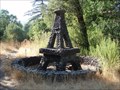
in Realistic Object Sculptures This is a random roadside sculpture along the scenic Redwood Highway (Rt. 199) near the post office in tiny Gasquet, California. There may have been a business, home or other building here at one time, or it may be a random placement. posted by: silverquill location: California date approved: 02/18/2009 last visited: 07/01/2010 |
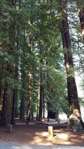
 view gallery view galleryNW12.2 km |  Mixed Evergreen Forests Mixed Evergreen Forests
in Flora and Fauna Information Signs This Flora and Fauna Sign is located in a turnout on the east side of US Highway 199 in the Jedediah Smith Redwood State Park northeast of Crescent City, California. posted by: brwhiz location: California date approved: 12/14/2012 last visited: never |
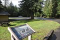 view gallery view galleryNW12.2 km | Redwood Country Wildlife in Flora and Fauna Information Signs This Flora and Fauna Sign is located in a turnout on the east side of US Highway 199 in the Jedediah Smith Redwood State Park northeast of Crescent City, California. posted by: brwhiz location: California date approved: 12/14/2012 last visited: never |
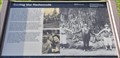 view gallery view galleryNW12.2 km |  Saving the Redwoods Saving the Redwoods
in Signs of History This historical marker is located in a turnout on the east side of US Highway 199 in the Jedediah Smith Redwood State Park about nine miles northeast of Crescent City, California. posted by: brwhiz location: California date approved: 12/13/2012 last visited: never |
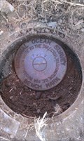
 view gallery view gallery W12.6 km W12.6 km
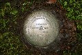
|  170-1915 RESET 1950 170-1915 RESET 1950
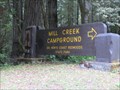
in U.S. Benchmarks A USGS Brass Disk Benchmark located in a concrete pillar at the SW corner of a bridge over Mill Creek on Howland Hill Road in Jedediah Smith Redwoods State Park. posted by: Geo-Surveyor location: California date approved: 02/27/2010 last visited: 10/06/2014 |
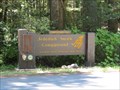 view gallery view galleryNW12.6 km |  Jedediah Smith Redwood SP - California Jedediah Smith Redwood SP - California
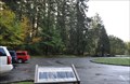
in State/Provincial Parks Jedediah Smith Redwood SP was established in 1929. This predominately old growth coast redwoods park is bisected by the last major free flowing river in California, the Smith River. The park protects 10,000 acres of primeval redwood groves. posted by: DougK location: California date approved: 07/17/2013 last visited: 06/13/2019 |
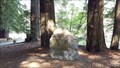 view gallery view galleryNW12.9 km |  National Tribute Grove - Jedediah State Park, CA National Tribute Grove - Jedediah State Park, CA
in World War II Memorials / Monuments Spreading out over 5000 acres, the National Tribute Grove, dedicated in 1949, is the largest World War II memorial in the United States. posted by: NW_history_buff location: California date approved: 09/08/2018 last visited: never |
 view gallery view galleryNW12.9 km |  LARGEST - World War II Memorial in the United States LARGEST - World War II Memorial in the United States
in Superlatives Spreading out over 5000 acres, the National Tribute Grove, dedicated in 1949, is the largest World War II memorial in the United States. posted by: NW_history_buff location: California date approved: 09/07/2018 last visited: never |
 view gallery view galleryW14.2 km | Del Norte Coast Redwood SP - California in State/Provincial Parks Del Norte Coast Redwood SP is just south of Crescent City, California. Because of it's coastal location on the Pacific Ocean, fog often surrounds the roads, forest and beaches. posted by: DougK location: California date approved: 07/17/2013 last visited: never |
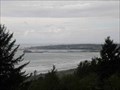 view gallery view galleryW15.1 km |  Crescent City Vista Point - California Crescent City Vista Point - California
in Scenic Roadside Look-Outs Crescent City Vista Point along U.S. Hwy. 101. posted by: Volcanoguy location: California date approved: 02/20/2014 last visited: 09/24/2013 |
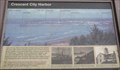 view gallery view galleryW15.1 km | Crescent City Harbor - California in Signs of History History sign at Crescent City Vista Point. posted by: Volcanoguy location: California date approved: 02/18/2014 last visited: 09/24/2013 |
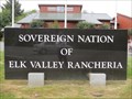 view gallery view galleryW16.9 km |  Elk Valley Rancheria - Crescent City, CA Elk Valley Rancheria - Crescent City, CA
in Nations Within Nations The Elk Valley Rancheria is a rancheria and federally recognized tribe of Tolowa and Yurok people. It is located in the CDP of Bertsch-Oceanview, Del Norte County, California, just east of Crescent City. posted by: DougK location: California date approved: 07/14/2013 last visited: never |
 view gallery view galleryW18.7 km | LV0563 - National Ocean Survey '941 9750 V TIDAL' BM - Crescent City, CA in U.S. Benchmarks This NGS Tidal benchmark is located under a pipe cap near the intersection of Hwy 101 and Citizens Dock Rd in Crescent City, CA. posted by: NW_history_buff location: California date approved: 09/05/2012 last visited: never |
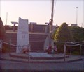 view gallery view galleryW18.8 km |  Lost at Sea Memorial Plaques - Crescent City Harbor, CA Lost at Sea Memorial Plaques - Crescent City Harbor, CA
in Maritime Monuments and Memorials These two memorial plaques within Crescent City Harbor are dedicated by the commercial fishermens wives to their commercial fishermen who lost their lives at sea. posted by: NW_history_buff location: California date approved: 11/11/2012 last visited: 05/26/2016 |
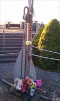 view gallery view galleryW18.8 km |  Lost at Sea Memorial Anchor - Crescent City, CA Lost at Sea Memorial Anchor - Crescent City, CA
in Anchors This memorial anchor and nautical flag pole within Crescent City Harbor stand in front of two memorial plaques dedicated by the commercial fishermens wives to their commercial fishermen who lost their lives at sea. posted by: NW_history_buff location: California date approved: 11/11/2012 last visited: never |
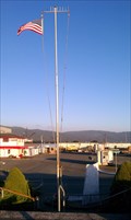 view gallery view galleryW18.8 km |  Lost at Sea Memorial Nautical Pole - Crescent City, CA Lost at Sea Memorial Nautical Pole - Crescent City, CA
in Nautical Flag Poles This nautical flag pole within Crescent City Harbor stands in front of two memorial plaques dedicated by the commercial fishermens wives to their commercial fishermen who lost their lives at sea. posted by: NW_history_buff location: California date approved: 11/10/2012 last visited: never |
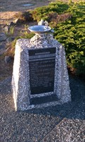 view gallery view galleryW18.8 km | Lost at Sea Memorial Fountain - Crescent City, CA in Maritime Monuments and Memorials This memorial plaque is located at the Inner Boat Basin within Crescent City Harbor in Crescent City, CA. posted by: NW_history_buff location: California date approved: 11/12/2012 last visited: never |
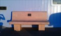 view gallery view galleryW18.8 km |  Arleon Parsons Bench - Crescent City, CA Arleon Parsons Bench - Crescent City, CA
in Dedicated Benches This dedicated bench is one of two located in front of the Crescent City Harbor Office. posted by: NW_history_buff location: California date approved: 12/02/2012 last visited: never |
|