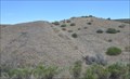
 view gallery view gallery W2.9 km W2.9 km
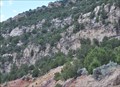
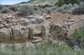
|   Uinta Fault Zone Uinta Fault Zone
in Places of Geologic Significance This fault zone has been exposed along a stretch of US Highway 191 northwest of Dutch John, Utah. posted by:  brwhiz brwhiz location: Utah date approved: 09/09/2013 last visited: 05/30/2016 |
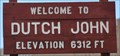 view gallery view gallery SE3.4 km SE3.4 km
|  Dutch John ~ Elevation 6312 Feet Dutch John ~ Elevation 6312 Feet
in Elevation Signs This Elevation Sign greets you at the western town limits on South Blvd. posted by: brwhiz location: Utah date approved: 09/11/2013 last visited: 10/08/2016 |
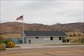 view gallery view gallerySE3.4 km |  Dutch John, Utah 84203 Dutch John, Utah 84203
in U.S. Post Offices Dutch John, Utah's Post Office posted by:  misfitt misfitt location: Utah date approved: 10/07/2007 last visited: never |
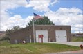 view gallery view gallerySE3.7 km |  Dutch John Fire Station Dutch John Fire Station
in Firehouses This is the only Firehouse in the small town of Dutch John, Utah. posted by: brwhiz location: Utah date approved: 09/04/2013 last visited: never |
 view gallery view gallery NW4.2 km NW4.2 km
| Baxter Shale (Mancos Shale) in Places of Geologic Significance This geological formation has been exposed along a stretch of US Highway 191 northwest of Dutch John, Utah. posted by: brwhiz location: Utah date approved: 09/18/2013 last visited: 05/30/2016 |
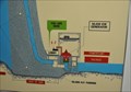
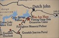
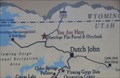 view gallery view galleryW4.3 km |  Antelope Flat Portal & Overlook Antelope Flat Portal & Overlook
in 'You Are Here' Maps You Are Here at the Antelope Flat Portal & Overlook northwest of Dutch John. posted by: brwhiz location: Utah date approved: 09/10/2013 last visited: 10/17/2017 |
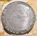
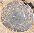 view gallery view galleryNW4.3 km |  USCGS LN0253 ~ M 102 USCGS LN0253 ~ M 102
in U.S. Benchmarks This US Benchmark is located along Spring Creek Road north of Dutch John, Utah and just south of the Utah, Wyoming border. posted by: brwhiz location: Utah date approved: 09/03/2013 last visited: never |
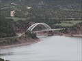
 view gallery view gallery S4.3 km S4.3 km
|  Flaming Gorge-Uintas National Scenic Byway - Dutch John, Utah Flaming Gorge-Uintas National Scenic Byway - Dutch John, Utah
in Scenic Roadside Look-Outs This excellent lookout along the Scenic Byway at Flaming Gorge is near Dutch John Utah. posted by: Mom the Cook & cashnhubby location: Utah date approved: 06/09/2011 last visited: 06/26/2017 |
 view gallery view galleryW4.3 km | Frontier Sandstone in Places of Geologic Significance This geological formation has been exposed along a stretch of US Highway 191 northwest of Dutch John, Utah. posted by: brwhiz location: Utah date approved: 09/18/2013 last visited: never |
 view gallery view gallerySE4.5 km | Flaming Gorge Interagency Fire and Aviation in Firehouses This Firehouse is located next to the Dutch John Airport. posted by: brwhiz location: Utah date approved: 09/04/2013 last visited: never |
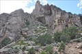 view gallery view galleryW4.5 km | Nugget Sandstone in Places of Geologic Significance This geological formation has been exposed along a stretch of US Highway 191 northwest of Dutch John, Utah. posted by: brwhiz location: Utah date approved: 09/18/2013 last visited: never |
 view gallery view gallery N4.7 km N4.7 km
|  Wyoming/Utah on US Highway 191 Wyoming/Utah on US Highway 191
in Border Crossings This Border Crossing is on US Highway 191 between Rock Springs, Wyoming and Vernal, Utah. posted by: brwhiz location: Utah date approved: 09/06/2013 last visited: 06/26/2017 |
 view gallery view galleryN4.7 km |  Welcome to Utah ~ Life Elevated Welcome to Utah ~ Life Elevated
in Welcome Signs This Welcome Sign greets you as you cross into Utah from Wyoming headed south on US Highway 191 toward Vernal, Utah. posted by: brwhiz location: Utah date approved: 09/04/2013 last visited: 05/30/2016 |
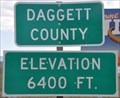 view gallery view galleryN4.7 km | Wyoming/Utah Border (Daggett County Line) ~ Elevation 6400 Feet in Elevation Signs This Elevation Sign is on the west side of US Highway 191 at the Wyoming/Utah Border about 8.2 miles north of Dutch John, Utah. posted by: brwhiz location: Utah date approved: 08/01/2013 last visited: 10/08/2016 |
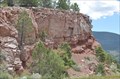 view gallery view galleryS4.7 km | Uinta Mountain Group in Places of Geologic Significance This geological formation has been exposed along a stretch of US Highway 191 near Dutch John, Utah. posted by: brwhiz location: Utah date approved: 09/03/2013 last visited: never |
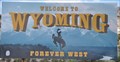 view gallery view galleryN4.7 km | Welcome to Wyoming ~ Forever West in Welcome Signs This Welcome Sign greets you as you cross into Wyoming from Utah headed north on US Highway 191 toward Rock Springs, Wyoming. posted by: brwhiz location: Wyoming date approved: 09/04/2013 last visited: 05/30/2016 |
 view gallery view galleryNW5 km | USGS LN0254 ~ 6 HJH in U.S. Benchmarks This US Benchmark is located along Spring Creek Road north of Dutch John, Utah and just south of the Utah, Wyoming border. posted by: brwhiz location: Utah date approved: 09/03/2013 last visited: never |
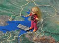
 view gallery view galleryS5 km | Flaming Gorge Powerplant Lobby in 'You Are Here' Maps You Are Here in the Powerplant Lobby at the base of the Flaming Gorge Dam. posted by: brwhiz location: Utah date approved: 09/10/2013 last visited: 05/30/2016 |
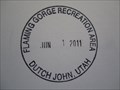 view gallery view galleryS5 km |  Flaming Gorge National Recreation Area - Dutch John, Utah Flaming Gorge National Recreation Area - Dutch John, Utah
in NPS Passport Cancellation Stations The Passport Cancellation station at Flaming Gorge Dam National Recreation Area is near Dutch John Utah. posted by: Mom the Cook & cashnhubby location: Utah date approved: 06/08/2011 last visited: 06/26/2017 |
 view gallery view galleryS5 km |  Flaming Gorge National Recreation Area - Dutch John, Utah Flaming Gorge National Recreation Area - Dutch John, Utah
in Official Local Tourism Attractions Within the Ashley National Forest in the high Uinta Mountains is the Flaming Gorge National Recreation Area. A beautiful area for a day tour or a longer trip for camping, fishing, or sightseeing, located in the northeastern section of the state. posted by: Mom the Cook & cashnhubby location: Utah date approved: 06/09/2011 last visited: 06/26/2017 |
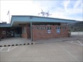 view gallery view galleryS5 km |  Flaming Gorge National Recreation Area Information - Daggett County , Utah Flaming Gorge National Recreation Area Information - Daggett County , Utah
in Tourist Information Centers - Visitor Centers Flaming Gorge Dam Visitor Center is a place of very kind locals, belonging to the County of Daggett. The closest populated place is that of Dutch John it is 2.69 miles from Flaming Gorge Dam Visitor Center. posted by: Mom the Cook & cashnhubby location: Utah date approved: 06/07/2011 last visited: 06/26/2017 |
 view gallery view galleryS5 km | Flaming Gorge Dam Orientation Center in 'You Are Here' Maps You Are Here at the Flaming Gorge Dam Orientation Center southwest of Dutch John. posted by: brwhiz location: Utah date approved: 09/10/2013 last visited: 05/30/2016 |
 view gallery view galleryS5 km | Flaming Gorge National Recreation Area Visitor Center in 'You Are Here' Maps You Are Here inside the Flaming Gorge National Recreation Area Visitor Center alongside the Flaming Gorge Dam south of Dutch John, Utah. posted by: brwhiz location: Utah date approved: 09/01/2013 last visited: 06/26/2017 |
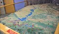 view gallery view galleryS5 km |  Flaming Gorge National Recreation Area Visitor Center Flaming Gorge National Recreation Area Visitor Center
in 3D Map Models of Our World and Beyond This 3D Map is in the Flaming Gorge National Recreation Area Visitor Center at the Flaming Gorge Dam south of Dutch John, Utah. posted by: brwhiz location: Utah date approved: 09/01/2013 last visited: 06/26/2017 |
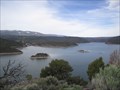
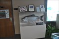 view gallery view galleryS5 km |  HEAVIEST -- Mackinaw Trout Caught in Utah HEAVIEST -- Mackinaw Trout Caught in Utah
in Superlatives On June 4, 1988, Kurt Bilbey caught a Mackinaw Trout weighing a record 51 pounds, 8 ounces, in Flaming Gorge Reservoir. posted by: brwhiz location: Utah date approved: 09/04/2013 last visited: 06/26/2017 |
|