 view gallery view gallery E19 km E19 km
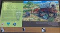
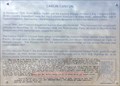
|   A Tale of Two Highways — Beowawe, NV A Tale of Two Highways — Beowawe, NV
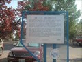
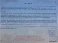
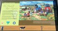
in Nevada Historical Markers History sign at the Beowawe Rest Area. posted by:  Volcanoguy Volcanoguy location: Nevada date approved: 11/10/2017 last visited: 09/24/2016 |
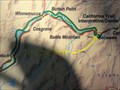 view gallery view galleryE19 km |  Beowawe, Nevada Beowawe, Nevada
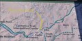
in 'You Are Here' Maps You Are Here marker on California Trail location map. posted by: Volcanoguy location: Nevada date approved: 11/08/2017 last visited: 09/24/2016 |
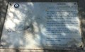 view gallery view galleryE19 km | Beowawe Geysers — Beowawe, NV in Nevada Historical Markers History sign at the Beowawe Rest Area. posted by: Volcanoguy location: Nevada date approved: 11/10/2017 last visited: 09/24/2016 |
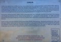
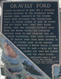 view gallery view galleryE19 km |  Gravely Ford - Carlin NV Gravely Ford - Carlin NV
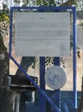
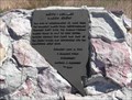
in Signs of History The marker is located at the at the Beowawe East Rest Area near Mile Marker 258, Interstate 80 near Carlin, Nevada, in Eureka County, NV, 89822. posted by:  Don.Morfe Don.Morfe location: Nevada date approved: 11/21/2023 last visited: 11/21/2023 |
 E19 km |  Gravely Ford Gravely Ford
in E Clampus Vitus Historical Markers 7 miles northwest of the location where Donner Party member James Reed stabbed John Snyder. posted by: elsietee location: Nevada date approved: 11/01/2013 last visited: 11/20/2023 |
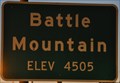 view gallery view gallery W20.6 km W20.6 km
|  Battle Mountain, Nevada (Southern Approach) ~ Elevation 4505 Feet Battle Mountain, Nevada (Southern Approach) ~ Elevation 4505 Feet
in Elevation Signs This Elevation Sign is located on the northeast side of Nevada Highway 304 (Front Street) at the southern town limit of Battle Mountain, Nevada. posted by: brwhiz location: Nevada date approved: 02/10/2013 last visited: 09/27/2014 |
 view gallery view galleryW20.8 km | #95 - Battle Mountain in Nevada Historical Markers Located on U.S. Highway 40 in Battle Mountain, Nevada posted by: Mountain_Wanderer location: Nevada date approved: 09/27/2008 last visited: 04/11/2017 |
 view gallery view galleryW24 km |  BM - Battle Mountain, NV BM - Battle Mountain, NV
in Letters on Hills The city of Battle Mountain, Nevada, has it initials in a northeast facing hillside just west of town. posted by: DougK location: Nevada date approved: 08/02/2011 last visited: 06/25/2014 |
 view gallery view gallery NW41.5 km NW41.5 km
| Valmy in Nevada Historical Markers This Nevada Historical Marker is in the Valmy Rest Area at Exit 216 of I-80. posted by: PeterNoG location: Nevada date approved: 10/27/2016 last visited: 09/24/2016 |
 view gallery view galleryNW41.7 km |  Valmy, Nevada 89438 Valmy, Nevada 89438
in U.S. Post Offices This Post Office is located at the northeast corner of Interstate 80 West, Exit 216 in Valmy, Nevada. The facility is at the east end of a building that also houses a combination convenience store and gas station. posted by: brwhiz location: Nevada date approved: 10/27/2011 last visited: never |
 view gallery view galleryE43.1 km | PALISADE in Nevada Historical Markers Nevada State Historical Marker No. 65 along Hwy. 278. posted by: Volcanoguy location: Nevada date approved: 11/26/2016 last visited: 09/24/2016 |
 view gallery view galleryE49.1 km | Carlin in Nevada Historical Markers Nevada State Historical Marker No. 112 in Carlin, Nevada. posted by: Volcanoguy location: Nevada date approved: 11/26/2016 last visited: 09/24/2016 |
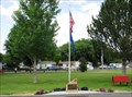 view gallery view galleryE49.2 km |  Vietnam War Memorial, Perry Memorial Park, Carlin, NV, USA Vietnam War Memorial, Perry Memorial Park, Carlin, NV, USA
in Vietnam War Memorials A small memorial consisting of a slab of local Nevada rock with a bronze dedication plaque and service symbol. Memorial is in the Memorial Park next to the baseball fields at B Street and West Railroad Ave posted by: HANSENNI location: Nevada date approved: 07/08/2010 last visited: never |
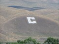 view gallery view galleryE50.2 km | C - Carlin, NV in Letters on Hills This C on a neighboring hillside is for Carlin, Nevada. posted by: DougK location: Nevada date approved: 07/14/2011 last visited: 06/25/2014 |
 view gallery view galleryE57.6 km | Carlin Canyon in Nevada Historical Markers Nevada State Historical Marker No. 50 posted by: Volcanoguy location: Nevada date approved: 11/28/2016 last visited: 09/24/2016 |
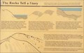 view gallery view galleryE57.6 km | The Rocks Tell a Story in Nevada Historical Markers History of the formation of Carlin Canyon posted by: Volcanoguy location: Nevada date approved: 11/29/2016 last visited: 09/24/2016 |
 view gallery view galleryE58.6 km |  California Trail marker C-39 California Trail marker C-39
in Wagon Roads and Trails California Trail Marker in Carlin Canyon posted by: Volcanoguy location: Nevada date approved: 12/05/2016 last visited: 09/24/2016 |
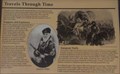 view gallery view galleryE58.6 km | Travels Through Time in Nevada Historical Markers Two adjacent signs with same title and continued text posted by: Volcanoguy location: Nevada date approved: 11/29/2016 last visited: 09/24/2016 |
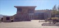 view gallery view galleryE65.7 km |  California Trail Interpretive Center — Elko, NV California Trail Interpretive Center — Elko, NV
in Nature Centers The California Trail Interpretive Center is located 8 miles west of Elko, Nevada. posted by: Volcanoguy location: Nevada date approved: 11/09/2017 last visited: 09/24/2016 |
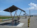 view gallery view gallery SW66 km SW66 km
|  Valley of the Moon - Rest Area - Nevada Valley of the Moon - Rest Area - Nevada
in Highway Rest Areas Located on NV SR 305 in Nevada. posted by: nvtriker location: Nevada date approved: 05/29/2009 last visited: 06/14/2010 |
 view gallery view galleryE66.6 km | California Trail Interpretive Center in 'You Are Here' Maps You Are Here at the entrance to the California Trail Interpretive Center west of Elko, Nevada on the north side of Interstate Highway 80 at Exit 292. posted by: brwhiz location: Nevada date approved: 09/16/2012 last visited: 09/24/2016 |
 view gallery view galleryE66.6 km | The End of the Hastings Cutoff in Nevada Historical Markers One of a group of signs at the entrance to The California Trail Interpretive Center. posted by: Volcanoguy location: Nevada date approved: 12/09/2016 last visited: 09/24/2016 |
 view gallery view galleryE66.6 km | The Humbolt River Highway in Nevada Historical Markers One of a group of signs at the entrance to The California Trail Interpretive Center. posted by: Volcanoguy location: Nevada date approved: 12/09/2016 last visited: 09/24/2016 |
 view gallery view galleryE66.6 km | California Trail marker C-38 in Wagon Roads and Trails California Trail Marker near The California Trail Interpretive Center posted by: Volcanoguy location: Nevada date approved: 12/05/2016 last visited: 09/24/2016 |
 view gallery view galleryE66.8 km | Hoppe-Lienhard Wagon Group in Nevada Historical Markers This Nevada Historical Marker is located on the south side of I-80 at exit 292. It's about 8 miles southwest of Elko, Nevada. posted by: PeterNoG location: Nevada date approved: 10/27/2016 last visited: 06/17/2019 |
|