 view gallery view gallery NW9.2 km NW9.2 km
|   Miriam Cemetery - Maryville, Mo. Miriam Cemetery - Maryville, Mo.
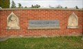
in Worldwide Cemeteries This Odd Fellows Cemetery is located on East Lieber in Maryville, Missouri. posted by:  iconions iconions location: Missouri date approved: 02/08/2010 last visited: 03/08/2014 |
 view gallery view galleryNW9.2 km |  Miriam IOOF Cemetery - Maryville, Mo. Miriam IOOF Cemetery - Maryville, Mo.
in Odd Fellow Lodges This Odd Fellows Cemetery is located on East Lieber in Maryville, Missouri. posted by: iconions location: Missouri date approved: 02/07/2010 last visited: 03/08/2014 |
 view gallery view gallery N9.3 km N9.3 km
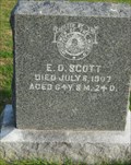
|  E. D. Scott - Miriam Cemetery - Maryville, Mo. E. D. Scott - Miriam Cemetery - Maryville, Mo.
in Woodmen of the World Grave Markers/Monuments This slab dark grey granite Woodman memorial is located towards the Southwestern part of the Miriam Cemetery - located on East Lieber Ave., in Maryville, Missouri. posted by: iconions location: Missouri date approved: 02/08/2010 last visited: never |
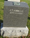 view gallery view galleryN9.3 km | G. T. Kimmons - Miriam Cemetery - Maryville, Mo. in Woodmen of the World Grave Markers/Monuments This slab dark grey granite Woodman memorial is located towards the Southwestern part of the Miriam Cemetery - located on East Lieber Ave., in Maryville, Missouri. posted by: iconions location: Missouri date approved: 02/09/2010 last visited: never |
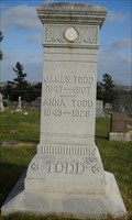 view gallery view galleryN9.3 km | James Todd - Miriam Cemetery - Maryville, Mo. in Woodmen of the World Grave Markers/Monuments This white marbleWoodman memorial is located towards the Southwestern part of the Miriam Cemetery - located on East Lieber Ave., in Maryville, Missouri. posted by: iconions location: Missouri date approved: 02/07/2010 last visited: never |
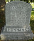 view gallery view galleryN9.3 km | Charles Lippman - Miriam Cemetery - Maryville, Mo. in Woodmen of the World Grave Markers/Monuments This slab grey granite Woodman memorial is located towards the Southwestern part of the Miriam Cemetery - located on East Lieber Ave., in Maryville, Missouri. posted by: iconions location: Missouri date approved: 02/07/2010 last visited: never |
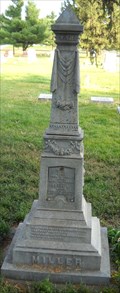 view gallery view galleryN9.3 km |  T. J. Miller - Miriam Cemetery - Maryville, Mo. T. J. Miller - Miriam Cemetery - Maryville, Mo.
in Zinc Headstones This column zinc marker is located in the Miriam Cemetery - on East Lieber - in Maryville, Missouri. posted by: iconions location: Missouri date approved: 02/11/2010 last visited: never |
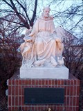 view gallery view galleryNW9.7 km |  St. Francis of Assisi - Maryville, MO, US St. Francis of Assisi - Maryville, MO, US
in Statues of Religious Figures This statue is located at the intersection of Lincoln and Main. No parking is available specifically for this statue. Park in a nearby lot and walk over. Be careful of traffic. posted by: TripCyclone location: Missouri date approved: 12/09/2012 last visited: never |
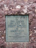 view gallery view galleryN10.6 km |  First House In Maryville - Maryville, Missouri First House In Maryville - Maryville, Missouri
in Missouri Historical Markers Marker for the first house in Maryville. posted by:  BruceS BruceS location: Missouri date approved: 12/11/2008 last visited: 12/13/2012 |
 view gallery view galleryN10.6 km |  FIRST - House In Maryville, - Maryville, Missouri FIRST - House In Maryville, - Maryville, Missouri
in First of its Kind Marker for the first house in Maryville. posted by: BruceS location: Missouri date approved: 12/12/2008 last visited: 12/13/2012 |
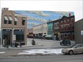 view gallery view galleryN10.6 km |  Historic Streetscape Mural - Maryville, Missouri Historic Streetscape Mural - Maryville, Missouri
in Murals Mural depicting a historic streetscape scene in Maryville, Missouri. posted by: BruceS location: Missouri date approved: 12/11/2008 last visited: 11/28/2012 |
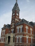
 view gallery view galleryN10.6 km |  Nodaway County Courthouse Clock - Maryville, Missouri Nodaway County Courthouse Clock - Maryville, Missouri
in Town Clocks Clock on county courthouse in Maryville, Missouri. posted by: BruceS location: Missouri date approved: 12/11/2008 last visited: never |
 view gallery view galleryN10.6 km |  Nodaway County Courthouse - Maryville, Missouri Nodaway County Courthouse - Maryville, Missouri
in U.S. National Register of Historic Places County courthouse in Maryville, Missouri. posted by: BruceS location: Missouri date approved: 12/11/2008 last visited: never |
 view gallery view galleryN10.6 km |  Nodaway County Courthouse - Maryville, Missouri Nodaway County Courthouse - Maryville, Missouri
in Courthouses County courthouse in Maryville, Missouri. posted by: BruceS location: Missouri date approved: 12/12/2008 last visited: 11/29/2008 |
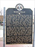 view gallery view galleryN10.6 km | Maryville in Missouri Historical Markers Historical marker giving history of Maryville and Nodaway County, located in front of the Nodaway County Courthouse in Maryville. posted by: BruceS location: Missouri date approved: 12/11/2008 last visited: 12/04/2012 |
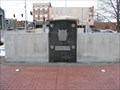 view gallery view galleryN10.6 km |  Nodaway County Veterans Memorial - Maryville, Missouri Nodaway County Veterans Memorial - Maryville, Missouri
in Non-Specific Veteran Memorials Veterans memorial on the grounds of the Nodaway County Courthouse in Maryville, Missouri. posted by: BruceS location: Missouri date approved: 12/12/2008 last visited: 05/26/2016 |
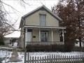 view gallery view galleryNW10.6 km | Burns, Caleb, House - Maryville, Missouri in U.S. National Register of Historic Places This house is documented as the oldest existing house in Maryville, Missouri.
posted by: BruceS location: Missouri date approved: 12/11/2008 last visited: never |
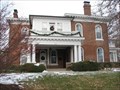
 view gallery view galleryN10.9 km | Frank House - Maryville, Missouri in U.S. National Register of Historic Places Historic Italianate styled house in Maryville, Missouri posted by: BruceS location: Missouri date approved: 12/12/2008 last visited: never |
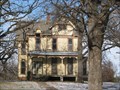
 view gallery view galleryNW11.1 km | Gaunt, Thomas, House - Maryville, Missouri in U.S. National Register of Historic Places The Thomas Gaunt House is a two-story, brick dwelling. It is owned by
Northwest Missouri State University, and is occupied by the president of the University.
posted by: BruceS location: Missouri date approved: 12/11/2008 last visited: 05/15/2011 |
 view gallery view gallery S29.6 km S29.6 km
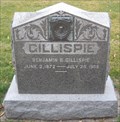
| Benjamin B. Gillispie - Bennett Lane Cemetery - Rural Andrew County in Woodmen of the World Grave Markers/Monuments This slab style Woodman headstone - of grey marble - is located in the Bennett Lane Cemetery. The Cemetery is on US 71 & County Road 151 posted by: iconions location: Missouri date approved: 02/09/2010 last visited: never |
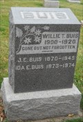 view gallery view galleryS29.6 km |  101 - Ida E. Buis - Bennett Lane Cemetery - Rural Andrew County, Missouri 101 - Ida E. Buis - Bennett Lane Cemetery - Rural Andrew County, Missouri
in Headstones of Centenarians This husband & wife headstone - of grey marble - is located in the Bennett Lane Cemetery. The Cemetery is on US 71 & County Road 151 posted by: iconions location: Missouri date approved: 02/09/2010 last visited: never |
 view gallery view gallery SW32.3 km SW32.3 km
|  N40 W95 2.2 miles SW of Fillmore, Andrew County, Missouri, USA N40 W95 2.2 miles SW of Fillmore, Andrew County, Missouri, USA
in Confluence Spots Another corn field posted by: txoilgas location: Missouri date approved: 01/16/2009 last visited: 03/26/2006 |
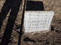 view gallery view galleryS33.3 km | Jackson Cemetery - Andrew County MO in Worldwide Cemeteries This small Cemetery is on County Road 71 about 1.4 east of State Highway H or 1 mile west of County Road 70 in Andrew County, Missouri. posted by: PeterNoG location: Missouri date approved: 03/19/2012 last visited: 01/04/2012 |
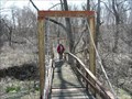 view gallery view galleryS34 km |  WPA Bridge - US 59 - Missouri WPA Bridge - US 59 - Missouri
in Pedestrian Suspension Bridges This swinging bridge was built by the WPA sometime between 1935 and 1943. It's in a small park on US 59 about 6 miles west of Savannah. posted by: PeterNoG location: Missouri date approved: 04/13/2008 last visited: 11/04/2012 |
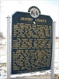 view gallery view gallery E34.1 km E34.1 km
| Gentry County in Missouri Historical Markers Historical marker giving a brief history of Gentry County and the towns in the county. posted by: BruceS location: Missouri date approved: 12/13/2008 last visited: never |
|