 view gallery view gallery W36.2 km W36.2 km
|   CDOT Rest Area: Wiggins, Colorado CDOT Rest Area: Wiggins, Colorado
in Highway Rest Areas 24-hour rest stop in Morgan County, Colorado posted by:  giacaches giacaches location: Colorado date approved: 04/28/2023 last visited: never |
 view gallery view gallery SW52.9 km SW52.9 km
|  Chapel Haven Seventh-day Adventist - Northglenn, CO Chapel Haven Seventh-day Adventist - Northglenn, CO
in Seventh-day Adventist Churches Local Seventh-day Adventist Church in Northglenn, Colorado, USA posted by: Outspoken1 location: Colorado date approved: 06/08/2010 last visited: never |
 view gallery view galleryW53.6 km |  Dearfield, Colorado Dearfield, Colorado
in Colorado Historical Markers Historic Ghost Town Dearfield, Colorado posted by: heishort location: Colorado date approved: 07/25/2013 last visited: never |
 view gallery view gallery NE54.1 km NE54.1 km
|  Sterling Depot - Sterling, CO Sterling Depot - Sterling, CO
in Relocated Structures The Sterling Union Pacific Depot was relocated off railroad property in 1984 to protect its status as a historical building. posted by: IJAdventures location: Colorado date approved: 02/19/2013 last visited: never |
 view gallery view galleryNE54.1 km |  Sterling Union Pacific Railroad Depot - Sterling, CO Sterling Union Pacific Railroad Depot - Sterling, CO
in U.S. National Register of Historic Places The Sterling Depot provides a glimpse of the past with its marvelous Victorian design. It was listed on the National Register in 1986. posted by: IJAdventures location: Colorado date approved: 02/19/2013 last visited: never |
 view gallery view galleryNE55.2 km |  Overland Trail Museum - Sterling, CO Overland Trail Museum - Sterling, CO
in History Museums At the instersection of Highway 6 and County Route 370, in Sterling, Colorado, the Overland Trail Park and Museum provides historical information and exhibits of the westward pioneer movement. posted by:  94RedRover 94RedRover location: Colorado date approved: 08/09/2009 last visited: never |
 view gallery view galleryNE55.2 km |  Overland Trail Museum - Sterling, CO Overland Trail Museum - Sterling, CO
in Roadside Attractions At the intersection of Highway 6 and County Route 370, in Sterling, Colorado, the Overland Trail Park and Museum provides historical information and exhibits of the westward pioneer movement. posted by: 94RedRover location: Colorado date approved: 08/09/2009 last visited: never |
 view gallery view galleryNE55.2 km |  Overland Trail Museum - Sterling, CO Overland Trail Museum - Sterling, CO
in Official Local Tourism Attractions At the intersection of Highway 6 and County Route 370, in Sterling, Colorado, the Overland Trail Park and Museum provides historical information and exhibits of the westward pioneer movement. posted by: 94RedRover location: Colorado date approved: 08/09/2009 last visited: never |
 view gallery view galleryNE55.2 km |  Overland Park - Sterling, CO Overland Park - Sterling, CO
in American Guide Series At the intersection of Highway 6 and County Route 370, in Sterling, Colorado, the Overland Trail Park and Museum provides historical information and exhibits of the westward pioneer movement. posted by: 94RedRover location: Colorado date approved: 08/09/2009 last visited: never |
 view gallery view galleryNE55.2 km | Site of Valley Station - Sterling, CO in American Guide Series At the intersection of Highway 6 and County Route 370, in Sterling, Colorado, the Overland Trail Park and Museum provides historical information and exhibits of the westward pioneer movement. posted by: 94RedRover location: Colorado date approved: 08/09/2009 last visited: never |
 view gallery view galleryNE55.2 km |  Valley Station - Overland Trail - Sterling, CO Valley Station - Overland Trail - Sterling, CO
in Wagon Roads and Trails At the insteresction of Highway 6 and County Route 370, in Sterling, Colorado, the Overland Trail Park and Museum provides historical information and exhibits of the westward pioneer movement. posted by: 94RedRover location: Colorado date approved: 08/09/2009 last visited: never |
 view gallery view galleryNE55.2 km | Valley Station - Sterling, CO in Colorado Historical Markers At the insteresction of Highway 6 and County Route 370, in Sterling, Colorado, the Overland Trail Park and Museum provides historical information and exhibits of the westward pioneer movement. posted by: 94RedRover location: Colorado date approved: 08/09/2009 last visited: never |
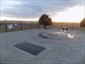
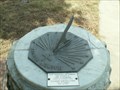 view gallery view galleryNE55.2 km |  Overland Trail Park Sundial - Sterling, CO Overland Trail Park Sundial - Sterling, CO
in Sundials At the intersection of Highway 6 and County Route 370, in Sterling, Colorado, the Overland Trail Park and Museum provides historical information and exhibits of the westward pioneer movement. posted by: 94RedRover location: Colorado date approved: 08/09/2009 last visited: never |
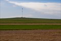
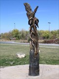 view gallery view galleryNE55.4 km |  "Metamorphosis" by Bradford Rhea, Sterling, Colorado "Metamorphosis" by Bradford Rhea, Sterling, Colorado
in Insect Sculptures An insect statue in the I-76 rest area in Sterling, Colorado posted by: KG1960 location: Colorado date approved: 10/18/2006 last visited: 07/27/2018 |
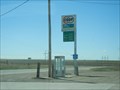 view gallery view gallery SE67.1 km SE67.1 km
|  Anton's Phone Booth Anton's Phone Booth
in Payphones Anton's Phone Booth posted by: LT_Dream location: Colorado date approved: 03/29/2015 last visited: never |
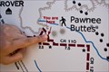 view gallery view gallery NW68.4 km NW68.4 km
|  "You Are Here" at Pawnee Buttes - Grover, CO "You Are Here" at Pawnee Buttes - Grover, CO
in 'You Are Here' Maps You are at the Pawnee Buttes trailhead in the Pawnee National Grassland. posted by: IJAdventures location: Colorado date approved: 06/13/2013 last visited: 05/03/2014 |
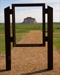 view gallery view galleryNW68.4 km |  Pawnee Buttes - Grover, CO Pawnee Buttes - Grover, CO
in Framed Views An old sign frame accents the main feature at the Pawnee Buttes trailhead. posted by: IJAdventures location: Colorado date approved: 06/14/2013 last visited: 07/25/2018 |
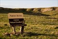
 view gallery view galleryNW68.4 km |  Pawnee Buttes Trailhead - Grover, CO Pawnee Buttes Trailhead - Grover, CO
in Hiking and walking trailheads A 1.5 mile trail leads to the base of the Pawnee Buttes in Pawnee National Grassland. posted by: IJAdventures location: Colorado date approved: 06/13/2013 last visited: 07/02/2016 |
 view gallery view galleryNW68.9 km |  Pawnee National Grassland - Grover, CO Pawnee National Grassland - Grover, CO
in Public Access Lands This grassland in northeastern Colorado provides many recreational opportunities such as wildlife and bird watching, hiking, camping and shooting. posted by: IJAdventures location: Colorado date approved: 06/07/2013 last visited: 11/09/2019 |
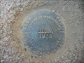 view gallery view gallerySE68.9 km |  KJ0176 (L56) - Washington County, CO KJ0176 (L56) - Washington County, CO
in U.S. Benchmarks KJ0176 (L56) Benchmark near Anton Colorado posted by: LT_Dream location: Colorado date approved: 03/29/2015 last visited: never |
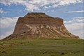 view gallery view galleryNW69.4 km | Pawnee Buttes - Grover, CO in American Guide Series Rising 300 feet above the surrounding landscape, these pillars are the most recognizable landmarks in the Pawnee National Grassland. posted by: IJAdventures location: Colorado date approved: 06/13/2013 last visited: 07/02/2016 |
 view gallery view galleryNW71.5 km | Seven Cross Hill - Briggsdale, CO in American Guide Series This hill served as a lookout point for the Seven Cross Ranch and is listed in Tour 2 (State 14) of the Colorado guide. posted by: IJAdventures location: Colorado date approved: 06/11/2013 last visited: 10/15/2016 |
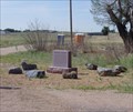
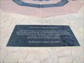
 view gallery view gallerySW77.6 km |  Monument planned to honor OSU Basketball plane crash victims - Byers, CO Monument planned to honor OSU Basketball plane crash victims - Byers, CO
in News Article Locations The pasture where the OSU plane crash occurred is now the site of a memorial posted by: Max and 99 location: Colorado date approved: 10/21/2019 last visited: never |
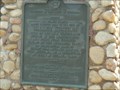
 view gallery view gallerySW77.6 km |  OSU Cowboys Basketball Team Crash - Strasburg, CO OSU Cowboys Basketball Team Crash - Strasburg, CO
in Plane Crash Sites Touching memorial to the ten who lost their lives returning to Oklahoma from a basketball game in Denver posted by: Outspoken1 location: Colorado date approved: 08/30/2010 last visited: 03/22/2015 |
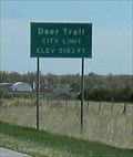 view gallery view gallerySW79.2 km |  Deer Trail, Colorado Elevation 5,183 Deer Trail, Colorado Elevation 5,183
in Elevation Signs Deer Trail, Colorado sits at 5,183 feet per the sign at the edge of town. posted by: Queens Blessing location: Colorado date approved: 05/28/2010 last visited: 09/02/2013 |
|