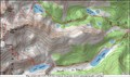
 view gallery view gallery SW3.5 km SW3.5 km
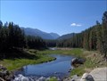
|   Arapaho Bay river bridge overlook - Granby, Co Arapaho Bay river bridge overlook - Granby, Co
in Scenic Roadside Look-Outs The parking lot to the right of the bridge has a wonderful view of the valley and river. posted by:  jdwms_1950 jdwms_1950 location: Colorado date approved: 07/04/2006 last visited: 07/10/2006 |
 view gallery view gallery NW10.8 km NW10.8 km
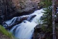
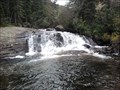
|  Adams Falls - Grand Lake, CO Adams Falls - Grand Lake, CO
in Waterfalls A short hike will take you to this picturesque waterfall in Rocky Mountain National Park. posted by:  IJAdventures IJAdventures location: Colorado date approved: 06/14/2012 last visited: 07/19/2017 |
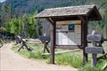 view gallery view galleryNW11.1 km |  East Inlet Trail at Rocky Mountain National Park - Grand Lake, CO East Inlet Trail at Rocky Mountain National Park - Grand Lake, CO
in Hiking and walking trailheads The East Inlet trail provides back-country access to the west side of Rocky Mountain National Park. Scenic features along the trail include Adams Falls, Lone Pine Lake, Lake Verna and Mt. Craig. posted by: IJAdventures location: Colorado date approved: 07/25/2012 last visited: 07/19/2017 |
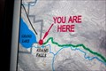 view gallery view galleryNW11.3 km |  "You Are Here" at East Inlet - Grand Lake, CO "You Are Here" at East Inlet - Grand Lake, CO
in 'You Are Here' Maps You are at the East Inlet to Grand Lake, Colorado's highest natural lake. posted by: IJAdventures location: Colorado date approved: 07/24/2012 last visited: never |
 view gallery view gallery SE12.1 km SE12.1 km
|  Pawnee Peak Pawnee Peak
in Mountain Summits A 13er wannabe in a very popular and accessable area. posted by: t-xman location: Colorado date approved: 10/02/2005 last visited: never |
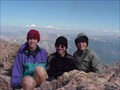
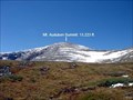 view gallery view gallerySE12.2 km |  Mt. Audubon Trail & Summit Mt. Audubon Trail & Summit
in Scenic Hikes Situated in the Indian Wilderness of Colorado's Front Range, Mount Audubon takes its place about one mile east of the Continental Divide and the resulting chain of rugged peaks that define the local geography. posted by: Team Laxson location: Colorado date approved: 09/14/2008 last visited: never |
 view gallery view gallerySE12.2 km | Mt. Audubon Summit (13,223) in Mountain Summits Situated in the Indian Wilderness of Colorado's Front Range, Mount Audubon takes its place about one mile east of the Continental Divide and the resulting chain of rugged peaks that define the local geography. posted by: Team Laxson location: Colorado date approved: 09/18/2008 last visited: 10/19/2008 |
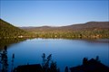 view gallery view galleryNW12.9 km |  LARGEST & DEEPEST -- Natural Lake in Colorado - Grand Lake, CO LARGEST & DEEPEST -- Natural Lake in Colorado - Grand Lake, CO
in Superlatives Grand Lake is both the largest and deepest natural lake in Colorado with 68,621 acre feet of water and 4 miles of shoreline. posted by: IJAdventures location: Colorado date approved: 07/25/2012 last visited: 09/26/2019 |
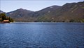 view gallery view galleryNW12.9 km |  Grand Lake - Grand Lake, CO Grand Lake - Grand Lake, CO
in Natural Lakes Grand Lake is the largest and deepest natural lake in Colorado located at the headwaters of the Colorado River. posted by: IJAdventures location: Colorado date approved: 07/24/2012 last visited: 09/26/2019 |
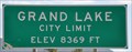 view gallery view galleryNW13.7 km |  Grand Lake, Colorado (Southern Approach) ~ Elevation 8369 Feet Grand Lake, Colorado (Southern Approach) ~ Elevation 8369 Feet
in Elevation Signs This Elevation Sign is located on the southeast side of US Highway 34, just southwest of the junction with County Road 691, at the southern town limits of Grand Lake, Colorado. posted by: brwhiz location: Colorado date approved: 02/10/2013 last visited: never |
 view gallery view galleryNW13.7 km |  Grand Lake, Colorado 80447 Grand Lake, Colorado 80447
in U.S. Post Offices This Post Office is located at 520 Center Drive in Grand Lake, Colorado. posted by: brwhiz location: Colorado date approved: 10/24/2011 last visited: never |
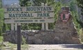 view gallery view galleryNW14.5 km |  Rocky Mountain National Park ~ Southwestern Entrance Rocky Mountain National Park ~ Southwestern Entrance
in National Parks of the World The southwestern entrance to Rocky Mountain National Park is on US Highway 34 (Trail Ridge Road) about one mile north of Grand Lake, Colorado. posted by: brwhiz location: Colorado date approved: 02/07/2013 last visited: 07/16/2017 |
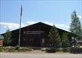
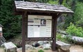
 view gallery view galleryNW15.1 km | Rocky Mountain National Park ~ Kawuneeche Visitor Center in National Parks of the World The Kawuneeche Visitor Center is located just inside the southwestern entrance to Rocky Mountain National Park on US Highway 34 north of Grand Lake, Colorado. posted by: brwhiz location: Colorado date approved: 02/14/2013 last visited: 07/16/2017 |
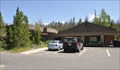 view gallery view galleryNW15.1 km |  Kawuneeche Visitor Center Kawuneeche Visitor Center
in Ranger Stations This Ranger Station is located just inside the southwestern entrance to Rocky Mountain National Park on US Highway 34 north of Grand Lake, Colorado. posted by: brwhiz location: Colorado date approved: 02/07/2013 last visited: 07/16/2017 |
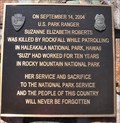 view gallery view galleryNW15.1 km |  U.S. Park Ranger Suzanne Elizabeth Roberts U.S. Park Ranger Suzanne Elizabeth Roberts
in Police Memorials This Police Memorial honoring a fallen National Parks Ranger is mounted on a rock monument in front of the Kawuneeche Visitor Center just inside the southwestern entrance to Rocky Mountain National Park on US Highway 34 north of Grand Lake, Colorado. posted by: brwhiz location: Colorado date approved: 02/07/2013 last visited: 10/09/2016 |
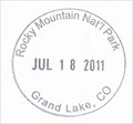 view gallery view galleryNW15.1 km |  Rocky Mountain National Park ~ Kawuneeche Visitor Center Passport Cancellation Station Rocky Mountain National Park ~ Kawuneeche Visitor Center Passport Cancellation Station
in NPS Passport Cancellation Stations This NPS Passport Cancellation Station is located inside the Kawuneeche Visitor Center just inside the southwestern entrance to Rocky Mountain National Park on US Highway 34 north of Grand Lake, Colorado. posted by: brwhiz location: Colorado date approved: 02/11/2013 last visited: 06/23/2018 |
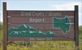 view gallery view gallerySW15.6 km |  Grand County/Granby Airport ~ Granby, Colorado Grand County/Granby Airport ~ Granby, Colorado
in Airports This Airport is located at the east end of County Road 610, one mile northeast of Granby, Colorado. posted by: brwhiz location: Colorado date approved: 02/15/2013 last visited: never |
 view gallery view gallery NE15.9 km NE15.9 km
| Copeland Falls, Rocky Mountain National Park in Waterfalls Less than 1/2 mile from the Wild Basin Trailhead in Rocky Mountain National Park, St. Vrain Creek cascades down the canyon through Upper and Lower Copeland Falls. Coordinates are just below Upper Copeland Falls. Photos taken 23 August 2012. posted by: EvilWickedMochaScout location: Colorado date approved: 08/24/2012 last visited: never |
 view gallery view galleryNE16.1 km | Longs Peak in Mountain Summits It was a long hike, but rewarding one. posted by: TeamJLB location: Colorado date approved: 11/20/2005 last visited: 03/15/2020 |
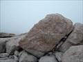
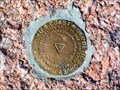 view gallery view galleryNE16.3 km |  LONGS PEAK (LL1346) - Boulder County, Colorado LONGS PEAK (LL1346) - Boulder County, Colorado
in U.S. Benchmarks A triangulation station on the summit of Longs Peak. posted by: Tom.dog location: Colorado date approved: 11/28/2022 last visited: never |
 view gallery view galleryNE16.3 km | Longs Peak Trail in Scenic Hikes The Longs Peak trail will take you through a variety of landscapes, from Forests, meadows, boulders, and those who brave it, the summit of Longs Peak. posted by: Team Laxson location: Colorado date approved: 07/21/2010 last visited: 10/10/1999 |
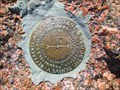
 view gallery view galleryNE16.3 km |  Longs Peak Summit Register (14,259) Longs Peak Summit Register (14,259)
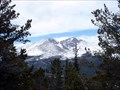
in Summit Registers Longs Peak is the highest mountain in the Rocky Mountain National Park, and dominates the skyline for much of Norther Colorado.
This summit register rests 14,259 above sea level. posted by: Team Laxson location: Colorado date approved: 07/21/2010 last visited: 10/02/1988 |
 view gallery view galleryNE16.3 km | LONGS PEAK NO 1 - Boulder County, Colorado in U.S. Benchmarks Reference mark 1 for triangulation station LONGS PEAK. posted by: Tom.dog location: Colorado date approved: 11/28/2022 last visited: never |
 view gallery view galleryNE16.6 km |  Wild Basin, Rocky Mountain National Park - Rocky Mountains National Park, CO Wild Basin, Rocky Mountain National Park - Rocky Mountains National Park, CO
in Wikipedia Entries Wild Basin is a scenic area in the southeastern part of Rocky Mountains National Park. The area is known for the creeks, waterfalls and wildflowers. posted by: hummerstation location: Colorado date approved: 11/06/2014 last visited: never |
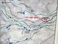 view gallery view galleryNE16.6 km | You Are Here - Wild Basin - Rocky Mountains National Park in 'You Are Here' Maps You Are Here map to provide orientation to the many trails in the Wild Basin area. posted by: hummerstation location: Colorado date approved: 07/25/2014 last visited: never |
|