 view gallery view gallery NE0.2 km NE0.2 km
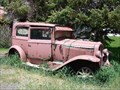
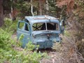
|   Scofield Dead Car # 1 Scofield Dead Car # 1
in Abandoned Dead Vehicles The Little town of Scofield, Utah is very nice, we saw this vehicle to waymark on a recent visit there. posted by:  JacobBarlow JacobBarlow location: Utah date approved: 06/04/2007 last visited: 06/15/2007 |
 view gallery view gallery SW0.2 km SW0.2 km
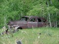
| Scofield Dead Car # 2 in Abandoned Dead Vehicles The Little town of Scofield, Utah is very nice, we saw this vehicle to waymark on a recent visit there. posted by: JacobBarlow location: Utah date approved: 06/04/2007 last visited: 06/15/2007 |
 view gallery view gallery S12.6 km S12.6 km
|  Monument Peak - Carbon County, UT Monument Peak - Carbon County, UT
in Mountain Summits Monument Peak is the county high point in Carbon County, Utah. This is one of the few Utah county high points that you can actually reach by driving. posted by:  Chasing Blue Sky Chasing Blue Sky location: Utah date approved: 08/24/2013 last visited: 09/07/2009 |
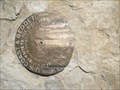 view gallery view galleryS12.6 km |  KN0369 - Monument Peak - Carbon County, UT KN0369 - Monument Peak - Carbon County, UT
in U.S. Benchmarks This benchmark indicates the summit of Monument Peak, the county high point in Carbon County, Utah. posted by: Chasing Blue Sky location: Utah date approved: 08/23/2013 last visited: 09/07/2009 |
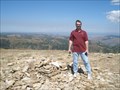 view gallery view galleryS12.6 km |  Monument Peak - Carbon County, UT Monument Peak - Carbon County, UT
in Geographic High Points Monument Peak is the county high point in Carbon County, Utah. This is one of the few Utah county high points that you can actually reach by driving. posted by: Chasing Blue Sky location: Utah date approved: 09/04/2013 last visited: 09/07/2009 |
 view gallery view gallery W16.9 km W16.9 km
| A Dead Car in the Mountains in Abandoned Dead Vehicles I found this dead Vehicle in Mountains posted by: robbdogg120 location: Utah date approved: 06/10/2007 last visited: never |
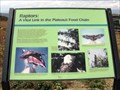 view gallery view gallerySW17.7 km |  Raptors, Skyline Drive, Utah Raptors, Skyline Drive, Utah
in Flora and Fauna Information Signs This sign is located on a scenic pull-off from Skyline Drive and describes the raptors that are common at the Wasatch Plateau. posted by: Queens Blessing location: Utah date approved: 10/28/2010 last visited: 08/09/2015 |
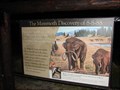 view gallery view gallerySW17.9 km |  The Mammoth Discovery of 8-8-88 The Mammoth Discovery of 8-8-88
in Utah Historical Markers The site of a surprising discovery, a Mammoth at over 9,000 feet elevation. posted by: JacobBarlow location: Utah date approved: 08/21/2007 last visited: 09/06/2021 |
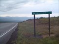
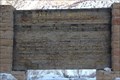
 view gallery view galleryNE18.8 km | Pleasant Valley Junction in Utah Historical Markers Pleasant Valley Junction about 1/2 mile south of this site, began in the early 1800's when the Rio Grande Railroad extended the main line from Tucker over the summit into Carbon County. posted by: JacobBarlow location: Utah date approved: 05/13/2007 last visited: 06/30/2018 |
 view gallery view galleryW22.7 km |  Milburn, Utah Milburn, Utah
in Wikipedia Entries Milburn is a town in Sanpete County, Utah, United States. The population was 1,160 at the 2000 census. posted by: JacobBarlow location: Utah date approved: 12/02/2007 last visited: 06/11/2012 |
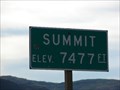 view gallery view gallery N23.3 km N23.3 km
|  Soldier Summit - Elevation 7477 Soldier Summit - Elevation 7477
in Elevation Signs The elevation for Soldier Summit is 7477. posted by: JacobBarlow location: Utah date approved: 09/18/2007 last visited: 06/30/2018 |
 view gallery view galleryN23.5 km |  Highway 6 Rest Area - Tucker, UT Highway 6 Rest Area - Tucker, UT
in Blue Star Memorial Highway Markers A rest area on U.S. Highway 6 posted by: DrJay location: Utah date approved: 08/15/2007 last visited: 06/30/2018 |
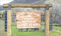 view gallery view gallerySW23.5 km |  Huntington & Eccles Canyons "Energy Loop" - National Scenic Byway - Utah Huntington & Eccles Canyons "Energy Loop" - National Scenic Byway - Utah
in National Scenic Byways Located between Fairview, Utah and Huntington, Utah along highway 31 posted by: Lord Mot location: Utah date approved: 05/23/2011 last visited: 06/18/2019 |
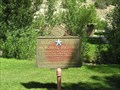
 view gallery view galleryN23.5 km | Soldier Summit in Utah Historical Markers On Sept. 11, 1776, two Franciscan Priests, Father Escalante & Father Dominguez entered what is now the state of Utah. posted by: JacobBarlow location: Utah date approved: 09/11/2007 last visited: 02/09/2019 |
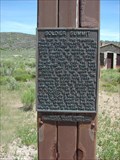
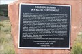
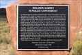 view gallery view galleryN23.5 km |  Soldier Summit A Failed Experiment - Soldier Summit, UT Soldier Summit A Failed Experiment - Soldier Summit, UT
in E Clampus Vitus Historical Markers An E Clampus Vitus historical marker stands near the old Soldier Summit calaboose/jail, noting the Peter Principle at work as part of this former town's "rise". Those who opted to move operations from Helper probably didn't have to live here! posted by: QuarrellaDeVil location: Utah date approved: 09/27/2018 last visited: never |
 view gallery view galleryN23.5 km | Soldier Summit A Failed Experiment - Soldier Summit, UT in Utah Historical Markers An E Clampus Vitus historical marker stands near the old Soldier Summit jail, noting the Peter Principle at work as part of this former town's "rise". Those who opted to move operations from Helper probably didn't have to live here! posted by: QuarrellaDeVil location: Utah date approved: 11/06/2018 last visited: never |
 view gallery view gallery E24.8 km E24.8 km
| Pleasant Valley Coal Company in Utah Historical Markers Historical marker giving brief history of a robbery at the Pleasant Valley Coal Company office. posted by:  BruceS BruceS location: Utah date approved: 07/05/2011 last visited: 06/20/2018 |
 view gallery view galleryE24.8 km | Pleasant Valley Coal Company - Castle Gate, Utah in E Clampus Vitus Historical Markers Historical marker giving brief history of a robbery at the Pleasant Valley Coal Company office. posted by: BruceS location: Utah date approved: 07/03/2011 last visited: 06/20/2018 |
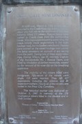
 view gallery view galleryE24.8 km | Castle Gate Mine Disaster in Utah Historical Markers At 8:30 a.m., March 8, 1924, an explosion occurred in the Castle Gate No. 2 Mine, located about one half miles to the southeast of this site, instantly killing 171 miners. Rescue teams were rushed to Castle Gate from the surrounding mines. posted by: JacobBarlow location: Utah date approved: 01/18/2008 last visited: 07/14/2015 |
 view gallery view galleryE24.8 km | Utah's Coal Industry in Utah Historical Markers The name Carbon County appropriately suggests the importance of carbon products to the economy and history of this area. The first commercial development of coal occurred in this vicinity in the 1870's and soon out-distanced production in other.... posted by: JacobBarlow location: Utah date approved: 01/18/2008 last visited: 07/14/2015 |
 view gallery view galleryE24.8 km | Castle Gate Mine disaster in Wikipedia Entries The Castle Gate mine disaster occurred on March 8, 1924, in a coal mine near the town of Castle Gate, Utah (now dismantled), located approximately 90 miles (145 km) southeast of Salt Lake City. All of the 171 men working in the mine were killed... posted by: JacobBarlow location: Utah date approved: 01/18/2008 last visited: 09/18/2016 |
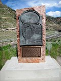
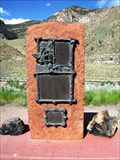 view gallery view galleryE24.8 km |  Castle Gate Mine Disaster Memorial - Castle Gate, Utah Castle Gate Mine Disaster Memorial - Castle Gate, Utah
in Disaster Memorials Memorial for tragic mine disaster located at pull out off US Hwy 6 near Castle Gate, Utah. posted by: BruceS location: Utah date approved: 07/04/2011 last visited: 03/31/2022 |
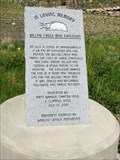 view gallery view galleryE24.8 km | Willow Creek Mine Explosion Memorial - Castle Gate, Utah in Disaster Memorials Memorial for a coal mine disaster near Castle Gate, Utah. The memorial is located at a pull off along US Hwy 6 southeast of Castle Gate. posted by: BruceS location: Utah date approved: 07/04/2011 last visited: 09/18/2016 |
 view gallery view galleryE24.8 km | Willow Creek Mine Explosion Memorial - Castle Gate, Utah in E Clampus Vitus Historical Markers Memorial for a coal mine disaster near Castle Gate, Utah. The memorial is located at a pull off along US Hwy 6 southeast of Castle Gate. posted by: BruceS location: Utah date approved: 07/03/2011 last visited: 07/14/2015 |
 view gallery view galleryE24.8 km | Carbon Plant in Utah Historical Markers Marker giving history of coal fired power plant at Castle Gate, Utah. posted by: BruceS location: Utah date approved: 07/05/2011 last visited: 07/14/2015 |
|