 view gallery view gallery SE7.1 km SE7.1 km
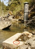
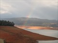
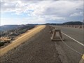
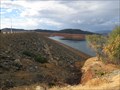
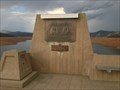
|   Lost Creek Reservoir Dam Lost Creek Reservoir Dam
in U.S. Benchmarks Bench mark located approx. 100yds downstream from Lost Creek Reservoir dam. posted by:  Dad2Dev Dad2Dev location: California date approved: 05/16/2009 last visited: never |
 view gallery view gallery SW9.3 km SW9.3 km
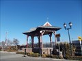
|  Union Pacific rail yard - Roseville CA Union Pacific rail yard - Roseville CA
in Active Rail Locations A raised concrete platform (about 8 x 10 ft)that raises the viewers above the protective fencing. Great for children. posted by:  sbcamper sbcamper location: California date approved: 02/04/2015 last visited: never |
 view gallery view gallery S12.9 km S12.9 km
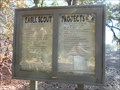
|  Jason Tanner - Sloughhouse , Sacramento Co, CA Jason Tanner - Sloughhouse , Sacramento Co, CA
in Eagle Scout Project Sites More than 20 Eagle Scout projects have been completed at this pioneer cemetery over as many years. They have rebuilt monuments, added a paved trail and handrail on a hillside, built a resting place, and posted by: sbcamper location: California date approved: 11/22/2017 last visited: never |
 view gallery view gallery W15.3 km W15.3 km
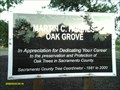
|  Martin C Hughes Grove - Sacramento CA Martin C Hughes Grove - Sacramento CA
in Dedicated Trees Marty retired from Sacramento Co. Public Works. He was the county Tree Coordinator, charged with protecting valley oak trees under county ordinance. Developers are required to replace any trees that are necessarily removed, by permit, or by penalty. posted by: sbcamper location: California date approved: 02/04/2015 last visited: never |
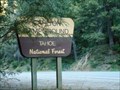 view gallery view gallerySE20.6 km |  Carlton Campground/ Tahoe National Forest CA Carlton Campground/ Tahoe National Forest CA
in Campgrounds 20 spaces on the Yuba River, some for tent camping,
$20/night. NO camping in undesignated areas on this forest or in Sierra County. PCT might be the exception. posted by: sbcamper location: California date approved: 07/22/2016 last visited: never |
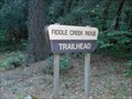 view gallery view gallerySE20.8 km |  Fiddle Creek Ridge Trail - Sierra Co. CA Fiddle Creek Ridge Trail - Sierra Co. CA
in Mountain Bike Trailheads 5.8 miles, 9 percent to 34 percent grade. posted by: sbcamper location: California date approved: 08/09/2016 last visited: never |
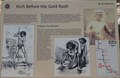 view gallery view gallerySE21.7 km |  Rich Before the Gold Rush - CA Hwy 49 Rich Before the Gold Rush - CA Hwy 49
in Signs of History History sign along CA Hwy 49. posted by: Volcanoguy location: California date approved: 08/27/2017 last visited: 10/10/2016 |
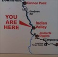 view gallery view gallerySE21.7 km |  Hwy 49 - Rich Before the Gold Rush sign - California Hwy 49 - Rich Before the Gold Rush sign - California
in 'You Are Here' Maps ‘You Are Here’ map along Hwy 49. posted by: Volcanoguy location: California date approved: 08/27/2017 last visited: 10/10/2016 |
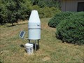 view gallery view gallerySE22.2 km |  Yuba River Ranger District - automated - CA Yuba River Ranger District - automated - CA
in Weather Stations R2D2? Solar and self reporting. posted by: sbcamper location: California date approved: 08/07/2016 last visited: never |
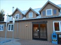
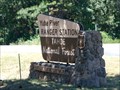 view gallery view gallerySE22.2 km |  Yuba River Ranger Station/USFS at Nevada County CA Yuba River Ranger Station/USFS at Nevada County CA
in Ranger Stations Business hours, M - F.
One of four ranger stations on the Tahoe National Forest. posted by: sbcamper location: California date approved: 07/27/2016 last visited: never |
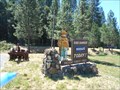 view gallery view gallerySE22.4 km |  Yuba Ranger Station Smokey - Camptonville CA Yuba Ranger Station Smokey - Camptonville CA
in Smokey Bear Sign Sightings Has a fire danger indicator/ moderate, high,low. posted by: sbcamper location: California date approved: 08/06/2016 last visited: never |
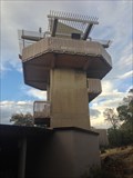 view gallery view galleryW23.7 km |  Visitor Center Tower - Oroville, California Visitor Center Tower - Oroville, California
in Look-Out Towers This Observation tower is located at the Lake Oroville Visitor Center. posted by: DougK location: California date approved: 04/04/2015 last visited: never |
 view gallery view galleryW23.7 km |  Lake Oroville SRA - California Lake Oroville SRA - California
in State/Provincial Parks Lake Oroville State Recreation Area is located on the Feather River in the chaparral-oak-pine belt of northern mother-lode country. Lake Oroville, about 75 miles north of Sacramento, is the largest state reservoir in northern California. posted by: DougK location: California date approved: 04/04/2015 last visited: never |
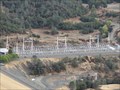
 view gallery view galleryW24.9 km |  TALLEST Dam in USA - Oroville, California TALLEST Dam in USA - Oroville, California
in Superlatives At 770 feet (230 m) high, the Oroville Dam on the Feather River is the tallest dam in the U.S. posted by: DougK location: California date approved: 10/06/2014 last visited: never |
 view gallery view galleryW24.9 km |  Oroville Dam - Oroville, California Oroville Dam - Oroville, California
in Water Dams Oroville Dam is an earthfill embankment dam on the Feather River east of the city of Oroville, California. At 770 feet (230 m) high, it is the tallest dam in the U.S. and serves mainly for water supply, hydroelectricity generation and flood control. posted by: DougK location: California date approved: 10/07/2014 last visited: 02/14/2017 |
 view gallery view galleryW24.9 km |  Oroville Dam & Edward Hyatt Power Plant - Feather River, California Oroville Dam & Edward Hyatt Power Plant - Feather River, California
in Engineering Landmarks The Oroville Dam and Powerplant received the ACSE Outstanding Projects and Leaders (OPAL) award a year after it was completed in 1969. posted by: DougK location: California date approved: 10/07/2014 last visited: never |
 view gallery view galleryW25.3 km |  Edward Hyatt Pump-Generating Plant - Oroville, California Edward Hyatt Pump-Generating Plant - Oroville, California
in Hydroelectric Power Stations In 1968, the Oroville Dam began to generate electricity after completion of the Edward Hyatt Pump-Generating Plant. At that time, it was the country's largest underground power station. posted by: DougK location: California date approved: 10/05/2014 last visited: never |
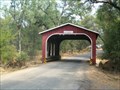
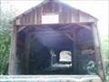 view gallery view gallerySE26.1 km |  Oregon Creek Covered Bridge - HW 49 CA Oregon Creek Covered Bridge - HW 49 CA
in Covered Bridges On the Middle Fork of the Yuba River, this bridge was relocated by a broken dam in 1883. It was rotated 180 degrees and came to rest here. posted by: sbcamper location: California date approved: 07/12/2016 last visited: never |
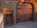 view gallery view gallerySW26.1 km |  Grey Fox Winery - Oroville CA Grey Fox Winery - Oroville CA
in Wineries Newer winery in Butte County (1996) posted by:  jimmonty jimmonty location: California date approved: 05/31/2008 last visited: 05/26/2008 |
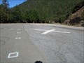 view gallery view gallery E26.2 km E26.2 km
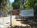
|  North side of the Yuba River/ Downieville CA North side of the Yuba River/ Downieville CA
in Helicopter Landing Pads Actually south of town on the highway. Elevations between town and top of the mountain rdges my differ by 1,000 feet. posted by: sbcamper location: California date approved: 07/07/2016 last visited: never |
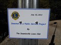 view gallery view galleryE26.2 km |  Downievillle/ HW 49 Lions Heliport - Sierra County CA Downievillle/ HW 49 Lions Heliport - Sierra County CA
in Lions Clubs International Markers Nevada Co. is the nearest airport or hospital. Steep mountains, high elevation, winding two lane road make this a real public service project. posted by: sbcamper location: California date approved: 07/07/2016 last visited: never |
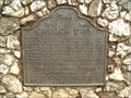 view gallery view galleryW27.5 km |  OREGON CITY, NO. 807 OREGON CITY, NO. 807
in California Historical Markers California Historical Landmark #807, northeast of Oroville. posted by: Johnny_Quest location: California date approved: 07/07/2008 last visited: 08/16/2013 |
 view gallery view galleryW27.5 km | Oregon City Covered Bridge, Oroville, CA in Covered Bridges A 50 foot, barn red bridge, northeast of Oroville, it crosses a dry creek bed. posted by: Johnny_Quest location: California date approved: 07/11/2008 last visited: 02/28/2016 |
 view gallery view galleryS28.2 km |  St John's Catholic Cemetery - North San Juan CA St John's Catholic Cemetery - North San Juan CA
in Worldwide Cemeteries Noted one gravestone as early as 1824. This is east of town.
One of 19 historic /natural cemeteries in Nevada County (one district).
The church deeded the property to the Nevada cemetery district. posted by: sbcamper location: California date approved: 07/07/2016 last visited: never |
 view gallery view galleryS28.2 km |  U S P O North San Juan CA U S P O North San Juan CA
in U.S. Post Offices 10 years new? Lots of P O boxes. posted by: sbcamper location: California date approved: 07/07/2016 last visited: never |
|