 view gallery view gallery SE1.1 km SE1.1 km
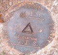
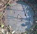
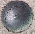
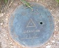
|   Baltimore County Survey Control GIS-136 Baltimore County Survey Control GIS-136
in U.S. Benchmarks A Baltimore County survey marker, being a brass disk in Owings Mills, Maryland. Mark is not documented on either geocaching.com or the NGS database. posted by:  NCPositronics NCPositronics location: Maryland date approved: 08/18/2019 last visited: 08/25/2019 |
 view gallery view gallery S1.3 km S1.3 km
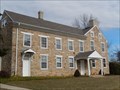
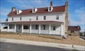
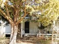
|  The Meadows (Owings Mills, Maryland) The Meadows (Owings Mills, Maryland)
in Wikipedia Entries The Meadows is a historic home and farm compound located at Owings Mills, Baltimore County, Maryland, United States. posted by:  Don.Morfe Don.Morfe location: Maryland date approved: 09/18/2021 last visited: 09/19/2021 |
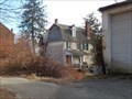
 view gallery view galleryS1.3 km |  Meadows, The - Owings Mills MD Meadows, The - Owings Mills MD
in U.S. National Register of Historic Places The overall integrity of the site with regard to location, design, setting, materials, workmanship, feeling and association is excellent, with all of the buildings being nominated surviving today largely as they stood. posted by: Don.Morfe location: Maryland date approved: 02/02/2021 last visited: 09/18/2021 |
 view gallery view gallery NE1.4 km NE1.4 km
| Owings Upper Mill - Owings Mills MD in U.S. National Register of Historic Places The Owings Upper Mill (also known as A.E. Groff's Flour Mill) is a historic grist mill located at Owings Mills, Baltimore County, Maryland, United States. It is a large ?3 1/2-story brick structure, 50 by 60 feet (15 by 18 m). posted by: Don.Morfe location: Maryland date approved: 02/02/2021 last visited: 09/21/2021 |
 view gallery view galleryNE1.4 km | Owings Upper Mill - Owings Mills MD in Wikipedia Entries The Owings Upper Mill (also known as A.E. Groff's Flour Mill) is a historic grist mill located at Owings Mills, Baltimore County, Maryland, United States. It is a large ?3 1/2-story brick structure, 50 by 60 feet (15 by 18 m). posted by: Don.Morfe location: Maryland date approved: 02/01/2021 last visited: 09/18/2021 |
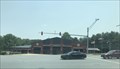 view gallery view galleryNE1.6 km |  Owing Mills Volunteer Fire Company Owing Mills Volunteer Fire Company
in Firehouses A fire station in Owing Mills, Maryland. posted by: bluesnote location: Maryland date approved: 07/29/2021 last visited: 07/08/2022 |
 view gallery view gallery E1.8 km E1.8 km
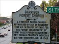
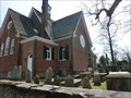
|  Garrison Forest Church (St. Thomas Parish) Garrison Forest Church (St. Thomas Parish)
in Maryland Historical Markers Marker is in Owings Mills, Maryland, in Baltimore County. posted by: miatabug location: Maryland date approved: 10/21/2008 last visited: 08/20/2021 |
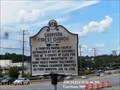 view gallery view galleryE1.8 km | Garrison, Maryland in Wikipedia Entries The GPS Coordinates are for the State of Maryland Historical Marker, "GARRISON FOREST CHURCH (St. Thomas Parish)" located on Reisterstown Road in Garrison MD. The church is listed on the U.S. National Register of Historic Places. posted by: Don.Morfe location: Maryland date approved: 12/04/2023 last visited: 07/25/2009 |
 view gallery view gallery SW2.1 km SW2.1 km
| Baltimore County Survey Control No. 198 in U.S. Benchmarks A Baltimore County Survey Control in Owings Mills, not documented on geocaching.com or the NGS database, and documented on the Baltimore County web site as GIS-198. posted by: NCPositronics location: Maryland date approved: 07/09/2019 last visited: 07/13/2019 |
 view gallery view galleryNE2.1 km | Stevenson University - Owings Mills MD in Wikipedia Entries The Location of the Owings Mills Campus is 100 Campus Circle, Owings Mills, MD United States 21117. posted by: Don.Morfe location: Maryland date approved: 12/04/2023 last visited: 03/19/2022 |
 view gallery view galleryNE2.1 km | Owings Mills, Maryland in Wikipedia Entries Owings Mills is an unincorporated community and census-designated place in Baltimore County, MD. The GPS Coordinates are for the entrance to Stevenson University, Owings Mills Campus located at 100 Campus Circle, Owings Mills, MD United States 21117. posted by: Don.Morfe location: Maryland date approved: 12/04/2023 last visited: 03/19/2022 |
 view gallery view galleryNE2.1 km |  Stevenson University - Owings Mills MD Stevenson University - Owings Mills MD
in Universities and Colleges Since our humble inception in the late 1940s, Stevenson University has continually evolved to meet the needs of students, gradually expanding both our physical presence and academic offerings. Here is a sampling of SU's rich history. posted by: Don.Morfe location: Maryland date approved: 02/22/2022 last visited: 03/19/2022 |
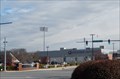
 view gallery view galleryNE2.1 km |  Mustang Stadium-Stevenson University - Owings Mills MD Mustang Stadium-Stevenson University - Owings Mills MD
in College Football Stadiums The stadium includes general admission seating for 3,000 fans and two-story press box that features a club level with 440 club seats, patio, President's Suite. posted by: Don.Morfe location: Maryland date approved: 03/30/2022 last visited: 04/03/2022 |
 view gallery view galleryS2.3 km | Plinlimmon Farm - Owings Mills MD in U.S. National Register of Historic Places Plinlimmon Farm is a historic home and farm complex located at Owings Mills. It is an early 19th-century farmhouse of log construction clad in novelty siding. It is composed of six irregularly spaced bays. posted by: Don.Morfe location: Maryland date approved: 02/02/2021 last visited: 09/18/2021 |
 view gallery view galleryS2.3 km | Plinlimmon Farm - Owings Mills MD in Wikipedia Entries Plinlimmon Farm is a historic home and farm complex located at Owings Mills. It is an early 19th-century farmhouse of log construction clad in novelty siding. It is composed of six irregularly spaced bays. posted by: Don.Morfe location: Maryland date approved: 02/01/2021 last visited: 09/18/2021 |
 view gallery view galleryS2.9 km | Baltimore County Survey Control CBM880 in U.S. Benchmarks A Baltimore County, Maryland survey marker, undocumented on either geocaching.com or the NGS web site, near Randallstown, Maryland. Mark is minimally documented on the Baltimore County web site as CBM880. posted by: NCPositronics location: Maryland date approved: 07/16/2019 last visited: 07/20/2019 |
 view gallery view galleryE2.9 km | St. Thomas Church (Owings Mills, Maryland) in Wikipedia Entries St. Thomas' Episcopal Church is a parish of the Episcopal Church in Owings Mills, Baltimore County, Maryland, part of the Diocese of Maryland. It is noted for its historic parish church, built in 1743. posted by: Don.Morfe location: Maryland date approved: 09/18/2021 last visited: 09/19/2021 |
 view gallery view galleryE2.9 km |  St. Thomas Church - Owings Mills MD St. Thomas Church - Owings Mills MD
in Anglican and Episcopal Churches Also known as Garrison Forest Church. St. Thomas Church is a historic Episcopal church. It was authorized in 1742 by the then Province of Maryland to provide a Chapel of Ease for early inhabitants of the Garrison Forest. posted by: Don.Morfe location: Maryland date approved: 01/09/2021 last visited: 09/18/2021 |
 view gallery view galleryE2.9 km |  St. Thomas Episcopal Church - Owings Mills MD St. Thomas Episcopal Church - Owings Mills MD
in This Old Church St. Thomas' Episcopal Church is a parish of the Episcopal Church in Owings Mills, Baltimore County, Maryland, part of the Diocese of Maryland. It is noted for its historic parish church, built in 1743. posted by: Don.Morfe location: Maryland date approved: 02/09/2023 last visited: 02/12/2023 |
 view gallery view galleryE2.9 km |  St. Thomas Church - Owings Mills MD St. Thomas Church - Owings Mills MD
in Churchyard Cemeteries Also known as Garrison Forest Church. St. Thomas Church is a historic Episcopal church. It was authorized in 1742 by the then Province of Maryland to provide a Chapel of Ease for early inhabitants of the Garrison Forest. posted by: Don.Morfe location: Maryland date approved: 01/10/2021 last visited: 09/18/2021 |
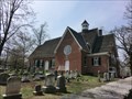 view gallery view galleryE2.9 km | St. Thomas Church - Owings Mills MD in U.S. National Register of Historic Places Also known as Garrison Forest Church. St. Thomas Church is a historic Episcopal church. It was authorized in 1742 by the then Province of Maryland to provide a Chapel of Ease for early inhabitants of the Garrison Forest. posted by: Don.Morfe location: Maryland date approved: 01/10/2021 last visited: 09/18/2021 |
 view gallery view galleryNE3.1 km | Caves Valley Historic District - Owings Mills MD in Wikipedia Entries Caves Valley Historic District is a national historic district near Owings Mills, Baltimore County, Maryland, United States. It is located in a natural upland valley encompassing about 2,100 acres (8.5 km2) along the North Branch of the Jones Falls. posted by: Don.Morfe location: Maryland date approved: 12/22/2021 last visited: 12/24/2021 |
 view gallery view galleryNE3.1 km |  Quattro House-Caves Valley Historic District - Owings Mills MD Quattro House-Caves Valley Historic District - Owings Mills MD
in NRHP Historic Districts - Contributing Buildings The Caves Valley Historic District is significant in the development of rural agriculture in Baltimore County, Maryland as a continuously farmed land tract from the mid-eighteenth century to the present. posted by: Don.Morfe location: Maryland date approved: 02/01/2021 last visited: 09/29/2021 |
 view gallery view galleryS3.2 km | Baltimore County Survey Control GIS-153 in U.S. Benchmarks A brass disk on the south side of Winands Road, west of Randallstown High School and approximately 18 inches south of the sidewalk. posted by: NCPositronics location: Maryland date approved: 06/16/2019 last visited: 06/22/2019 |
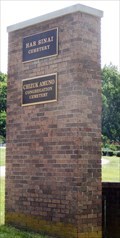 view gallery view galleryNE3.4 km |  Har Sinai Cemetery and Chizuk Amuno Congregation Cemetery - Owings Mills MD Har Sinai Cemetery and Chizuk Amuno Congregation Cemetery - Owings Mills MD
in Worldwide Cemeteries The cemetery entrance is shared with Har Sinai Cemetery and Chizuk Amuno Cemetery and it is located in Owings Mills MD. posted by: Don.Morfe location: Maryland date approved: 07/08/2022 last visited: 01/02/2023 |
|