 view gallery view gallery SE2.7 km SE2.7 km
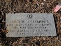
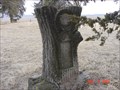
|   Archie Clements - Arnold Cemetery - Rural Lafayette County, Mo. Archie Clements - Arnold Cemetery - Rural Lafayette County, Mo.
in Grave of a Famous Person Archie Clements was "Bloody" Bill Anderson's Top Lieutenant and took over Anderson's Ranger Group after Anderson's death in October of 1864. posted by:  iconions iconions location: Missouri date approved: 02/16/2012 last visited: never |
 view gallery view gallery W5.3 km W5.3 km
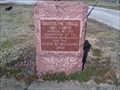
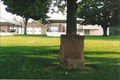
|  Santa Fe Trail Marker - Levasy Santa Fe Trail Marker - Levasy
in Wagon Roads and Trails Santa Fe Trail marker placed off of Old Lexington Road in Levasy. posted by:  betaylor73 betaylor73 location: Missouri date approved: 04/01/2009 last visited: 04/01/2012 |
 view gallery view gallery E6.6 km E6.6 km
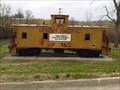
|  UP Caboose 25612 - Wellington, MO UP Caboose 25612 - Wellington, MO
in Train Cabooses UP caboose 25612 sitting on the grounds of the city park in Wellington, Missouri. posted by: betaylor73 location: Missouri date approved: 04/04/2009 last visited: 05/24/2009 |
 view gallery view gallery N7.4 km N7.4 km
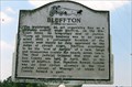
|  Bluffton - Ray County, MO Bluffton - Ray County, MO
in Ghost Towns Once the county seat, now gone posted by: YoSam. location: Missouri date approved: 04/07/2014 last visited: 09/05/2015 |
 view gallery view galleryN7.4 km |  First County Seat of Ray County, MO First County Seat of Ray County, MO
in First of its Kind 1st town, and 1st county seat, but when the river moved 3 miles south [Missouri River] and the county seat moved to Richmond, Bluffton was a gonner. But first it had a bunch of firsts. posted by: YoSam. location: Missouri date approved: 04/06/2014 last visited: never |
 view gallery view galleryN7.4 km |  Bluffton - west of Camden, MO Bluffton - west of Camden, MO
in Missouri Historical Markers History of a ghost town. posted by: YoSam. location: Missouri date approved: 02/29/2008 last visited: 04/26/2009 |
 view gallery view galleryE7.7 km | Potawatomi "Trail of Death" March - Wellington, MO in Missouri Historical Markers The Indian Tribe was forced from Indiana to Kansas, like the Cherokees from Alabama. Andrew Jackson's actions as president. Oct. 27th, 1838. posted by: YoSam. location: Missouri date approved: 06/19/2008 last visited: 01/05/2012 |
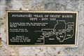 view gallery view galleryE7.7 km |  Potawatomi "Trail of Death" March - Wellington, MO Potawatomi "Trail of Death" March - Wellington, MO
in Trail of Tears Oct. 27 & 28, 1838. A child died today. posted by: YoSam. location: Missouri date approved: 06/25/2008 last visited: 09/05/2019 |
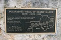 view gallery view galleryE7.7 km |  Potawatomi "Trail of Death" March - Wellington, MO Potawatomi "Trail of Death" March - Wellington, MO
in Civil Rights Memorials The Indian Tribe was forced from Indiana to Kansas, like the Cherokees from Alabama. Andrew Jackson's actions as president. Oct. 27th, 1838. posted by: YoSam. location: Missouri date approved: 04/19/2020 last visited: never |
 view gallery view galleryE7.7 km |  Wellington, Missouri Wellington, Missouri
in Wikipedia Entries "July 1852 – Cholera broke out in Wellington begin brought and spread by a man named Patterson. Mrs. A.N. Duck, mother of Mr. Davis K. Duck died 7/15 and about the same date a male slave belonging to Mr. Alex Sheer." ~ 1984 by Joanne C. Eakin posted by: YoSam. location: Missouri date approved: 04/19/2016 last visited: never |
 view gallery view galleryE7.7 km |  Santa Fe Trail - Wellington, MO, USA Santa Fe Trail - Wellington, MO, USA
in Daughters of the American Revolution This was once US Hwy 24, and the original Santa Fe Trail posted by: YoSam. location: Missouri date approved: 11/06/2023 last visited: never |
 view gallery view galleryE7.7 km | Santa Fe Trail - Wellington, MO in Missouri Historical Markers This was once US Hwy 24, and the original Santa Fe Trail posted by: YoSam. location: Missouri date approved: 04/13/2015 last visited: 09/05/2019 |
 view gallery view galleryE7.7 km |  Wellington MO 64097 Wellington MO 64097
in U.S. Post Offices This Post Office is on Highway 224 (5th Street) between Walnut Street and Cherry St in Wellington, Missouri. posted by: PeterNoG location: Missouri date approved: 03/20/2012 last visited: 01/04/2012 |
 view gallery view galleryE7.7 km |  "Borgman-Osthoff /Post 134" - Wellington MO "Borgman-Osthoff /Post 134" - Wellington MO
in Legion Posts and Branches This American Legion Post is on Highway 224 (5th Street) between Walnut Street and Cherry St in Wellington, Missouri. It's right beside the Post Office. posted by: PeterNoG location: Missouri date approved: 03/18/2012 last visited: 01/04/2012 |
 view gallery view galleryE7.7 km | Santa Fe Trail Marker - Wellington in Wagon Roads and Trails Santa Fe Trail marker placed in a small park in the Wellington town square. posted by: betaylor73 location: Missouri date approved: 04/14/2009 last visited: 08/15/2007 |
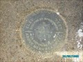 view gallery view galleryE7.7 km |  KD0623 - B220 - Wellington, MO KD0623 - B220 - Wellington, MO
in U.S. Benchmarks Bench mark disk B220 in Wellington, MO posted by: betaylor73 location: Missouri date approved: 09/26/2008 last visited: 09/25/2008 |
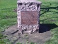
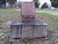
 view gallery view galleryE9.7 km |  Daniel W. Goan near Camden, Missouri Daniel W. Goan near Camden, Missouri
in Woodmen of the World Grave Markers/Monuments Daniel W. Goan gravestone in Sunshine Cemetery, Ray County, Missouri posted by: moraycc location: Missouri date approved: 03/08/2009 last visited: 04/26/2009 |
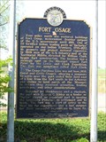 view gallery view galleryW10.8 km | Fort Osage - Buckner, Mo. in Missouri Historical Markers This marker is located at Heisler Park in Buckner, Mo. posted by: iconions location: Missouri date approved: 07/22/2012 last visited: 04/01/2012 |
 view gallery view gallery NW12.1 km NW12.1 km
| Santa Fe Trail Marker - Fort Osage in Wagon Roads and Trails Santa Fe Trail marker placed near historic Fort Osage. posted by: betaylor73 location: Missouri date approved: 04/03/2009 last visited: 05/24/2009 |
 view gallery view galleryNW12.2 km |  Fort Osage - Sibley MO Fort Osage - Sibley MO
in Lewis and Clark Trail During their famous expedition up the Missouri River in seeking the Northwest Passage to the Pacific Ocean, Americans Meriwether Lewis and William Clark noted this spot in June 1804, as they camped for the night just across the river. posted by: nomadwillie location: Missouri date approved: 03/08/2022 last visited: never |
 view gallery view galleryNW12.2 km |  Fort Osage - Sibley, MO Fort Osage - Sibley, MO
in Historic Forts Fort Osage (also known as Fort Clark or Fort Sibley) was an early 19th-century factory trading post run by the United States Government in western Missouri on the American frontier; it was located in present-day Sibley, Missouri. posted by: nomadwillie location: Missouri date approved: 03/02/2022 last visited: never |
 view gallery view galleryNW12.2 km |  Fort Osage - Sibley, MO Fort Osage - Sibley, MO
in U.S. National Register of Historic Places Fort Osage (also known as Fort Clark or Fort Sibley) was an early 19th-century factory trading post run by the United States Government in western Missouri on the American frontier; it was located in present-day Sibley, Missouri. posted by: nomadwillie location: Missouri date approved: 02/26/2022 last visited: never |
 view gallery view galleryNW12.2 km | Fort Osage - Sibley, MO in Wikipedia Entries Fort Osage (also known as Fort Clark or Fort Sibley) was an early 19th-century factory trading post run by the United States Government in western Missouri on the American frontier; it was located in present-day Sibley, Missouri. posted by: nomadwillie location: Missouri date approved: 02/26/2022 last visited: never |
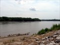 view gallery view galleryNW12.2 km |  Fort Osage Boat Ramp Fort Osage Boat Ramp
in Boat Ramps Missouri River boat ramp. posted by: wardnkathy location: Missouri date approved: 05/31/2009 last visited: never |
 view gallery view gallery S15 km S15 km
|  Oak Grove, Mo. Municipal Flag Oak Grove, Mo. Municipal Flag
in Municipal Flags This colorful flag flies outside the Oak Grove City Hall. posted by: iconions location: Missouri date approved: 05/30/2011 last visited: never |
|