 view gallery view gallery N5.8 km N5.8 km
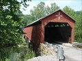
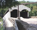
|   Carrollton Covered Bridge Carrollton Covered Bridge
in Covered Bridges Carrollton Covered Bridge
Carrollton Rd, Carrollton (unincorporated community in Barbour County), WV, USA
Emmett & Daniel O'Brien
Bridge No. 2013
Built in 1856
Rehabilitated 2003 posted by:  jlmasonwv jlmasonwv location: West Virginia date approved: 08/09/2007 last visited: 10/02/2015 |
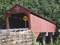 view gallery view galleryN5.8 km |  Carrolton Covered Bridge Carrolton Covered Bridge
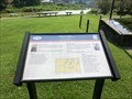
in U.S. National Register of Historic Places Carrolton Covered Bridge is located just off SR 36 on Carrollton Road in Carrollton, Barbour County, West Virginia. posted by:  deano1943 deano1943 location: West Virginia date approved: 08/19/2007 last visited: 08/19/2007 |
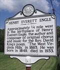 view gallery view galleryN7.9 km |  Henry Everett Engle Henry Everett Engle
in West Virginia Historical Markers The Henry Everett Engle Historical Marker is located South of Philippi along US Rt. 119. posted by: deano1943 location: West Virginia date approved: 08/20/2007 last visited: 09/17/2015 |
 view gallery view gallery E11.3 km E11.3 km
|  Belington WV 26250 Belington WV 26250
in U.S. Post Offices Belington WV 26250 Post Office posted by: dukemartin location: West Virginia date approved: 02/26/2013 last visited: never |
 view gallery view galleryE11.3 km |  Skirmish at Camp Laurel Hill - Belington WV Skirmish at Camp Laurel Hill - Belington WV
in Battlefields Many received their baptism of fire here as Garnett's 4,000 Confederates skirmished with an equal force under General Thomas A. Morris on July 7-11, 1861. posted by: Don.Morfe location: West Virginia date approved: 11/21/2020 last visited: 10/16/2021 |
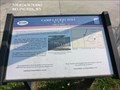 view gallery view galleryE11.3 km |  Camp Laurel Hill-A Key to Victory - Belington WV Camp Laurel Hill-A Key to Victory - Belington WV
in U.S. Civil War Sites On the nearby heights, Confederate General Robert Garnett's Army of Northwestern Virginia built fortifications to defend the Beverly-Fairmont Turnpike in June 1861. posted by: Don.Morfe location: West Virginia date approved: 07/03/2023 last visited: 07/03/2023 |
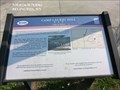 view gallery view galleryE11.3 km |  Camp Laurel Hill-A Key to Victory - Belington WV Camp Laurel Hill-A Key to Victory - Belington WV
in Signs of History On the nearby heights, Confederate General Robert Garnett's Army of Northwestern Virginia built fortifications to defend the Beverly-Fairmont Turnpike in June 1861. posted by: Don.Morfe location: West Virginia date approved: 08/30/2023 last visited: 08/30/2023 |
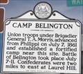 view gallery view galleryE11.3 km | Camp Belington in West Virginia Historical Markers Tells about fighting that took place here during the beginning of the Civil War. posted by: Paintedwarrior location: West Virginia date approved: 02/26/2013 last visited: 08/30/2023 |
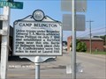 view gallery view galleryE11.3 km | Camp Belington - Belington, WV in American Civil War Monuments and Memorials Marker Location is on the east side of Route 250, Belington, WV posted by: Don.Morfe location: West Virginia date approved: 09/02/2023 last visited: 09/02/2023 |
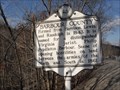
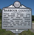 view gallery view gallery NW11.6 km NW11.6 km
| Barbour County / Upshur County in West Virginia Historical Markers A two sided sign telling when and where the counties were formed from. posted by: Paintedwarrior location: West Virginia date approved: 04/22/2013 last visited: 04/27/2013 |
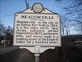 view gallery view galleryE11.6 km | Meadowville in West Virginia Historical Markers Tells about the early years of Meadowville. posted by: Paintedwarrior location: West Virginia date approved: 02/26/2013 last visited: 03/02/2013 |
 view gallery view gallery SE11.9 km SE11.9 km
| Barbour County / Randolph County in West Virginia Historical Markers A two sided sign telling about the formation of the two counties. posted by: Paintedwarrior location: West Virginia date approved: 03/01/2013 last visited: 03/02/2013 |
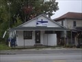 view gallery view gallerySE12.1 km | Junior, WV 26275 Post Office in U.S. Post Offices Junior, WV 26275 Post Office posted by: Paintedwarrior location: West Virginia date approved: 10/13/2014 last visited: never |
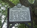 view gallery view gallery W12.4 km W12.4 km
| Pringle Tree in West Virginia Historical Markers This sign is located within the fenced area next to the Pringle tree that housed John and Samuel Pringle. posted by: Paintedwarrior location: West Virginia date approved: 07/01/2013 last visited: 07/06/2013 |
 view gallery view galleryN12.4 km | Philippi - West Virginia - 26416 in U.S. Post Offices Philippi Post Office is located in Philippi Borough, Barbour County, West Virginia. posted by: deano1943 location: West Virginia date approved: 08/19/2007 last visited: 02/23/2013 |
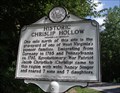 view gallery view galleryNW12.6 km | Historic Chrislip Hollow in West Virginia Historical Markers The Histrical Marker "Historic Chrislip Hollow" is located near Elk City along WV 57 and Scales Road. posted by: deano1943 location: West Virginia date approved: 08/20/2007 last visited: 10/23/2011 |
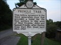 view gallery view galleryW12.6 km | Pringle Tree in West Virginia Historical Markers Pringle Tree West Virginia Historical Marker posted by: jlmasonwv location: West Virginia date approved: 08/20/2007 last visited: 06/28/2013 |
 view gallery view galleryN12.6 km | Philippi-The Commands - Philippi WV in U.S. Civil War Sites Marker is in Philippi, West Virginia, in Barbour County at the intersection of Mansfield Drive (U.S. 250) and North Main Street (U.S. 250). Philippi WV 26416 posted by: Don.Morfe location: West Virginia date approved: 07/11/2023 last visited: 07/11/2023 |
 view gallery view galleryN12.6 km | Philippi Covered Bridge in Covered Bridges Philippi Covered Bridge is located at the Jct. of US 250 and US 119 in Barbour County, West Virginia.
posted by: deano1943 location: West Virginia date approved: 08/19/2007 last visited: 08/18/2022 |
 view gallery view galleryN12.6 km | Philippi Covered Bridge in U.S. National Register of Historic Places Philippi Covered Bridge is located at the Jct. of US 250 and US 119 in Barbour County, West Virginia. posted by: deano1943 location: West Virginia date approved: 08/19/2007 last visited: 08/18/2022 |
 view gallery view galleryN12.7 km |  The Philippi Covered Bridge - Philippi, WV The Philippi Covered Bridge - Philippi, WV
in Wikipedia Entries The Philippi Covered Bridge is the oldest and longest covered bridge in West Virginia and one of only two remaining in Barbour County. It is also the only covered bridge on the United States Numbered Highway System (as part of U.S. Route 250). posted by: Don.Morfe location: West Virginia date approved: 03/13/2023 last visited: 03/14/2023 |
 view gallery view galleryN12.7 km |  Philippi Covered Bridge - Philippi, WV Philippi Covered Bridge - Philippi, WV
in Official Local Tourism Attractions The Philippi Covered Bridge is the oldest and longest covered bridge in West Virginia and one of only two remaining in Barbour County. It is also the only covered bridge on the United States Numbered Highway System (as part of U.S. Route 250). posted by: Don.Morfe location: West Virginia date approved: 03/13/2023 last visited: 03/14/2023 |
 view gallery view galleryN12.7 km |  OLDEST in West Virginia - The Philippi Covered Bridge - Philippi, WV OLDEST in West Virginia - The Philippi Covered Bridge - Philippi, WV
in Superlatives The Philippi Covered Bridge is the oldest and longest covered bridge in West Virginia and one of only two remaining in Barbour County. It is also the only covered bridge on the United States Numbered Highway System (as part of U.S. Route 250). posted by: Don.Morfe location: West Virginia date approved: 03/13/2023 last visited: 03/14/2023 |
 view gallery view galleryN12.7 km | The Philippi Covered Bridge - Philippi, WV in Signs of History The covered bridge, erected in 1852, is the only two-lane bridge in the federal highway system. posted by: Don.Morfe location: West Virginia date approved: 08/29/2020 last visited: 09/26/2021 |
 view gallery view galleryN12.7 km |  Philippi Covered Bridge - Philippi, WV Philippi Covered Bridge - Philippi, WV
in Satellite Imagery Oddities The Philippi Covered Bridge is the oldest and longest covered bridge in West Virginia and one of only two remaining in Barbour County. It is also the only covered bridge on the United States Numbered Highway System (as part of U.S. Route 250). posted by: Don.Morfe location: West Virginia date approved: 03/14/2023 last visited: 03/14/2023 |
|