 view gallery view gallery E1.1 km E1.1 km
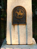
|   7 - William Watters Gravesite - McLean, VA 7 - William Watters Gravesite - McLean, VA
in Historic United Methodist Sites William Watters was the first Methodist minister who was a native of North America. This marker is located at the site of his grave in McLean, Virginia. posted by:  Hikenutty Hikenutty location: Virginia date approved: 06/24/2008 last visited: 06/25/2017 |
 view gallery view gallery W1.6 km W1.6 km
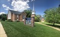
|  Church of Christ Scientist - McLean, Virginia Church of Christ Scientist - McLean, Virginia
in Church of Christ Scientist Located along Chain Bridge Road in Mclean. posted by:  flyingmoose flyingmoose location: Virginia date approved: 10/29/2020 last visited: never |
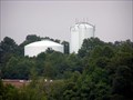 view gallery view galleryW2.3 km |  McLean Duo at Dulles Toll road and 123 McLean Duo at Dulles Toll road and 123
in Water Towers A brother and sister water tower photo, taken from Capital One Drive parking lot and 123 in McLean, Va. posted by: DoUW4W location: Virginia date approved: 07/23/2008 last visited: never |
 view gallery view gallery NE2.4 km NE2.4 km
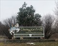
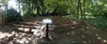
|  Clemyjontri Park Clemyjontri Park
in Accessible-Designed Recreational Locations Located on the eastern end of Georgetown Pike before it intersects with Dolly Madison Boulevard. posted by: flyingmoose location: Virginia date approved: 02/18/2021 last visited: never |
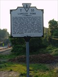 view gallery view galleryNE2.6 km |  Langley Fork Langley Fork
in Virginia Historical Markers Located along the westbound side of route 193/ Georgetown pike. There is ample parking along the road, even in traffic. There is also a sports park along the same road with the name Langley fork that is primarily a soccer field. posted by: flyingmoose location: Virginia date approved: 05/26/2006 last visited: 01/22/2022 |
 view gallery view gallery S2.9 km S2.9 km
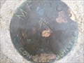
|  Beacon Hill (HV8335) - Falls church, VA Beacon Hill (HV8335) - Falls church, VA
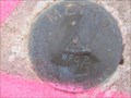
in U.S. Benchmarks survey disk in sidewalk in front of Beacon Hill neighborhood of Falls Church posted by: hrothroc location: Virginia date approved: 11/03/2022 last visited: 11/02/2022 |
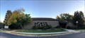
 view gallery view galleryW3.2 km |  Capital One - Tysons Corner, Virginia Capital One - Tysons Corner, Virginia
in Publicly Held Corporation Headquarters Located at the intersection of Capital One Drive and Scotts Crossing Road. posted by: flyingmoose location: Virginia date approved: 08/18/2021 last visited: never |
 view gallery view gallery SE3.4 km SE3.4 km
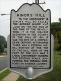
| Minor's Hill in Virginia Historical Markers Minor's Hill was the site of a Confederate outpost early in the Civil War, and later housed a Union signal station. posted by: macdonr location: Virginia date approved: 08/30/2006 last visited: 09/10/2006 |
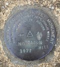
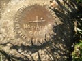
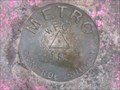 view gallery view galleryS3.4 km | METRO WFC-1R, Virginia in U.S. Benchmarks METRO WFC-1R, VA, is a survey disk mounted in a sidewalk near a bus stop at the West Falls Church METRO station in Fairfax County, VA. posted by: seventhings location: Virginia date approved: 01/09/2006 last visited: never |
 view gallery view galleryS3.4 km | METRO WFC-2, Virginia in U.S. Benchmarks METRO WFC-2, VA, is a survey disk mounted in a sidewalk near the bus-only lane entrance to the West Falls Church METRO station in Fairfax County, VA. posted by: seventhings location: Virginia date approved: 01/09/2006 last visited: never |
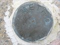
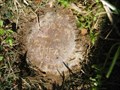
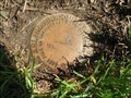
 view gallery view galleryE3.4 km | PHRA8 in U.S. Benchmarks PHRA8 is an Arlington County geodetic control disk.
posted by: Black Dog Trackers location: Virginia date approved: 04/29/2006 last visited: 08/21/2016 |
 view gallery view gallery SW3.4 km SW3.4 km
| METRO DX-171, Virginia in U.S. Benchmarks METRO DX-171, VA, is a survey disk mounted in the top of a concrete wall near an outdoor parking lot near the West Falls Church METRO station in Fairfax County, VA. posted by: seventhings location: Virginia date approved: 01/09/2006 last visited: never |
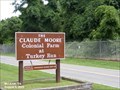 view gallery view galleryNE3.4 km |  Claude Moore Colonial Farm - McLean VA Claude Moore Colonial Farm - McLean VA
in Wikipedia Entries Claude Moore Colonial Farm, originally Turkey Run Farm, was a U.S. park in Virginia re-creating and re-enacting life on a tenant farm circa 1771. It located at 6310 Georgetown Pike, McLean, VA 22101. posted by: Don.Morfe location: Virginia date approved: 01/07/2024 last visited: 01/07/2024 |
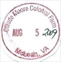
 view gallery view galleryNE3.4 km |  Ranger Station at Claude Moore Colonial Farm - McLean VA Ranger Station at Claude Moore Colonial Farm - McLean VA
in Ranger Stations The Ranger Station at Claude Moore Colonial Farm is in the visitor center. Here one may obtain a NPS Cancellation Stamp. posted by: Don.Morfe location: Virginia date approved: 01/08/2024 last visited: 01/08/2024 |
 view gallery view gallerySW3.4 km | METRO WFC-8, Virginia in U.S. Benchmarks METRO WFC-8, VA, is a survey disk mounted in a sidewalk on an overpass of an exit lane from Interstate Highway 66 near the West Falls Church METRO station in Fairfax County, VA. posted by: seventhings location: Virginia date approved: 01/09/2006 last visited: never |
 view gallery view gallerySE3.5 km |  Little Falls Presbyterian Church - Arlington, Virginia Little Falls Presbyterian Church - Arlington, Virginia
in Outdoor Altars An outdoor section of the church in the wooded lot next to the rear parking lot. posted by: flyingmoose location: Virginia date approved: 02/09/2021 last visited: never |
 view gallery view gallerySE3.5 km | PHRA19 in U.S. Benchmarks PHRA19 in Arlington, Virginia posted by: Black Dog Trackers location: Virginia date approved: 04/29/2006 last visited: never |
 view gallery view gallerySE3.5 km |  Little Falls Presbyterian Church - Arlington, Virginia Little Falls Presbyterian Church - Arlington, Virginia
in Presbyterian Churches Church is located in northern Arlington, ample parking when church is not in session. posted by: flyingmoose location: Virginia date approved: 07/28/2020 last visited: never |
 view gallery view galleryE3.5 km | PHRA7 in U.S. Benchmarks Station PHRA7 in Arlington Virginia. posted by: Black Dog Trackers location: Virginia date approved: 04/29/2006 last visited: 08/21/2016 |
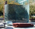 view gallery view galleryNE3.7 km | KRYPTOS in Wikipedia Entries Kryptos is a sculpture at the headquarters of the Central Intelligence Agency. Dedicated in 1990, it bears an encrypted message, that remains unsolved. Hidden on the back cover of Dan Brown's novel The Da Vinci Code are coordinates found on Kryptos. posted by: bravo872 location: Virginia date approved: 11/12/2009 last visited: never |
 view gallery view gallerySE3.7 km | BN31 in U.S. Benchmarks BN31 in Arlington, Virginia posted by: Black Dog Trackers location: Virginia date approved: 04/29/2006 last visited: 08/21/2016 |
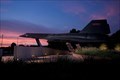 view gallery view galleryNE3.9 km |  A-12 (Oxcart) - Langley, Virginia A-12 (Oxcart) - Langley, Virginia
in Static Aircraft Displays Located at the CIA Headquarters in Langley, Virginia. Access is limited to employees or guest during special events. posted by: flyingmoose location: Virginia date approved: 06/16/2020 last visited: never |
 view gallery view galleryNE3.9 km | ") Claude Moore Colonial Farm Claude Moore Colonial Farm
in National Parks (U.S.) The original Turkey Run Farm was designed and built as an educational opportunity to simulate how poor, 18th-century farmers lived and worked. However, it was a representation only, and there is no historical evidence that this area was a Colonial farm. posted by: Don.Morfe location: Virginia date approved: 12/18/2019 last visited: 10/28/2021 |
 view gallery view galleryNE3.9 km |  Claude Moore Colonial Farm Claude Moore Colonial Farm
in NPS Passport Cancellation Stations The NPS operated the farm until 1981 until budget considerations. Supporters rallied and formed the Friends of Turkey Run, Later renamed the Claude Moore Colonial Farm. posted by: Don.Morfe location: Virginia date approved: 12/25/2019 last visited: 10/10/2021 |
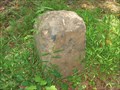 view gallery view galleryS3.9 km |  Washington DC Boundary Stone - West Washington DC Boundary Stone - West
in U.S. Historic Survey Stones and Monuments Washington DC Boundary Stone - West
This is the west cornerstone of the series of Washington DC boundary markers established in 1791 and 1792 to establish the boundaries of the District of Columbia. posted by: Black Dog Trackers location: Virginia date approved: 10/21/2006 last visited: 06/14/2020 |
|