 view gallery view gallery W8.9 km W8.9 km
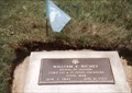
|   William E.Richey-Harveyville, KS William E.Richey-Harveyville, KS
in Medal Of Honor Resting Places Civil War Medal of Honor Recipient for action at Chickamauga, GA on September 19, 1863. He is buried in Harveyville Cemetery, Harveyville, KS in Lot 8, Space 3. posted by:  Don.Morfe Don.Morfe location: Kansas date approved: 04/16/2019 last visited: 12/05/2021 |
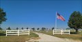 view gallery view gallery S15.1 km S15.1 km
|  Rapp Cemetery - Rapp, KS Rapp Cemetery - Rapp, KS
in Worldwide Cemeteries Rapp Cemetery (and the old Rapp Schoolhouse) are on the north side of Highway 56, just north of Rapp, Kansas. posted by:  The Snowdog The Snowdog location: Kansas date approved: 09/04/2023 last visited: never |
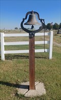 view gallery view galleryS15.3 km |  Rapp School Bell - Rapp, KS Rapp School Bell - Rapp, KS
in Bells The old Rapp School Bell is on display at the Rapp Schoolhouse - in Rapp, Kansas. posted by: The Snowdog location: Kansas date approved: 09/04/2023 last visited: never |
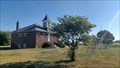 view gallery view galleryS15.3 km |  Rapp School - Rapp, KS Rapp School - Rapp, KS
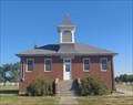
in Former Schools This red-brick one-room eight-grade schoolhouse is in Rapp, Kansas. posted by: The Snowdog location: Kansas date approved: 09/04/2023 last visited: never |
 view gallery view galleryS15.3 km |  Rapp School - Rapp, KS Rapp School - Rapp, KS
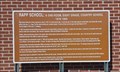
in Kansas Historical Markers This marker relates the history of the Rapp School - in Rapp, Kansas. posted by: The Snowdog location: Kansas date approved: 09/05/2023 last visited: never |
 view gallery view galleryS15.3 km |  Rapp School - Rapp, KS Rapp School - Rapp, KS
in One-Room Schoolhouses This red-brick one-room eight-grade schoolhouse is in Rapp, Kansas. posted by: The Snowdog location: Kansas date approved: 09/05/2023 last visited: never |
 view gallery view galleryS15.3 km |  Rapp School Playground - Rapp, KS Rapp School Playground - Rapp, KS
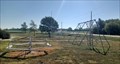
in Public Playgrounds The children's play equipment at Rapp School is available to all - in Rapp, Kansas. posted by: The Snowdog location: Kansas date approved: 09/04/2023 last visited: never |
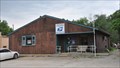
 view gallery view gallery E15.8 km E15.8 km
|  Carbondale, KS 66414 Carbondale, KS 66414
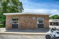
in U.S. Post Offices Located at 201-299 Main St, Carbondale, KS posted by: nomadwillie location: Kansas date approved: 01/01/2020 last visited: never |
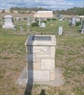
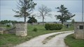 view gallery view galleryE17.4 km | Carbondale Cemetery - Carbondale, Ks in Worldwide Cemeteries This large rural cemetery is located at the corners of E 149th & S Adams. It is located SE of the town of Carbondale. posted by: iconions location: Kansas date approved: 05/16/2009 last visited: 09/07/2014 |
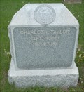 view gallery view galleryE17.5 km |  Charles V Taylor - Carbondale Cemetery - Carbondale, Ks Charles V Taylor - Carbondale Cemetery - Carbondale, Ks
in Woodmen of the World Grave Markers/Monuments This marble monument with seal is located in the Carbondale cemetery. The cemetery is at the corners of E 149th & S Adams. Some of the outer roads in the cemetery are new and are still very soft.
posted by: iconions location: Kansas date approved: 05/16/2009 last visited: 09/07/2014 |
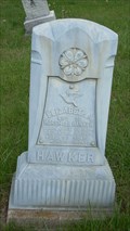 view gallery view galleryE17.5 km |  Hawker - Carbondale Cemetery - Carbondale, Ks Hawker - Carbondale Cemetery - Carbondale, Ks
in Zinc Headstones This small zinc headstone from 1906 is located in a very large rural cemetery SE of the town of Carbondale Ks. The Cemetery is at the corners of E 149th & S Adams. posted by: iconions location: Kansas date approved: 05/16/2009 last visited: 09/07/2014 |
 view gallery view gallery N20.1 km N20.1 km
|  Dover Cemetery Veterans Memorial - Dover, KS Dover Cemetery Veterans Memorial - Dover, KS
in Non-Specific Veteran Memorials This modest veterans memorial is in Dover Cemetery - in Dover, Kansas. posted by: The Snowdog location: Kansas date approved: 05/11/2023 last visited: never |
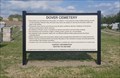 view gallery view galleryN20.1 km | Dover Cemetery - Dover, KS in Worldwide Cemeteries Dover Cemetery is a few miles west of Dover, Kansas. posted by: The Snowdog location: Kansas date approved: 05/11/2023 last visited: never |
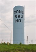 view gallery view galleryN20.6 km |  Consolodated Rural Water District No. 1 Water Column Consolodated Rural Water District No. 1 Water Column
in Water Towers This Water Column is located on the south side of SW 57th Street southwest of Topeka, Kansas. posted by: brwhiz location: Kansas date approved: 02/22/2013 last visited: never |
 view gallery view galleryN20.9 km | Dover, Kansas 66420 in U.S. Post Offices This Post Office is located at 13538 SW 57th Street in Dover, Kansas. posted by: brwhiz location: Kansas date approved: 09/03/2012 last visited: never |
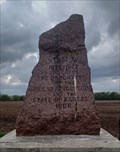 view gallery view galleryW21.1 km | Santa Fe Trail Marker - Admire, KS in Kansas Historical Markers This Santa Fe Trail Marker is on the west side of Highway 99 - north of Admire, Kansas. posted by: The Snowdog location: Kansas date approved: 05/11/2023 last visited: never |
 view gallery view galleryW21.1 km |  Santa Fe Trail Marker - Admire, KS Santa Fe Trail Marker - Admire, KS
in Wagon Roads and Trails This Santa Fe Trail Marker is on the west side of Highway 99 - north of Admire, Kansas. posted by: The Snowdog location: Kansas date approved: 05/11/2023 last visited: never |
 view gallery view galleryW21.1 km |  Santa Fe Trail Marker - Admire, KS, USA Santa Fe Trail Marker - Admire, KS, USA
in Daughters of the American Revolution This Santa Fe Trail Marker on the west side of Highway 99 was set by the Daughters of the American Revolution - north of Admire, Kansas. posted by: The Snowdog location: Kansas date approved: 05/10/2023 last visited: never |
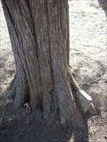 view gallery view gallery NE21.6 km NE21.6 km
|  Headstone eating tree - Yocum Cemetery - Shawnee County, Ks Headstone eating tree - Yocum Cemetery - Shawnee County, Ks
in Omnivorous Trees This example of an Omnivorous Tree is located in the Yocum Cemetery in rural Shawnee County Southeast of Topeka on SE101st near the intersection oc S California Road. posted by: iconions location: Kansas date approved: 08/08/2009 last visited: 03/14/2010 |
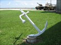 view gallery view galleryNE24 km |  Combat Air Museum, Topeka, KS ANCHOR? Combat Air Museum, Topeka, KS ANCHOR?
in Anchors Is this Anchor lost? posted by: BackPak location: Kansas date approved: 08/30/2007 last visited: 03/03/2019 |
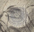 view gallery view galleryNE24.3 km |  NGS Benchmark JE1763 - Shawnee County, Ks NGS Benchmark JE1763 - Shawnee County, Ks
in U.S. Benchmarks This disk is located 1/2 mile south of SE101st ST on S Croco Rd. posted by: iconions location: Kansas date approved: 02/26/2009 last visited: never |
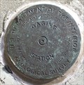 view gallery view galleryNE26.6 km | USGS Benchmark 06891260 - Shawnee County, Ks in U.S. Benchmarks This gauging station mark is located on the Wakarusa River on the NW corner of the SE Paulen Rd Bridge in rural Shawnee County, Ks.
posted by: iconions location: Kansas date approved: 03/01/2009 last visited: never |
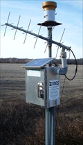 view gallery view galleryNE26.6 km |  Wakarusa River Gauge 06891260 - near Richland, Ks Wakarusa River Gauge 06891260 - near Richland, Ks
in River Gauges This gauge is located on the Wakarusa River on the NW corner of the SE Paulen Rd Bridge. posted by: iconions location: Kansas date approved: 02/23/2009 last visited: never |
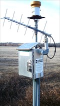 view gallery view galleryNE26.6 km |  Wakarusa River Solar Powered Gauge - near Richland, Ks Wakarusa River Solar Powered Gauge - near Richland, Ks
in Solar Power This gauge is located on the Wakarusa River on the NW corner of the SE Shadden Rd Bridge.
posted by: iconions location: Kansas date approved: 02/28/2009 last visited: never |
 view gallery view galleryN26.6 km |  Abrams Burnett - Topeka, KS Abrams Burnett - Topeka, KS
in Out of Place Graves The grave of Abrams Burnette, Chief of the Pottawatomies, is at the end of a dike in Topeka, Kansas. posted by: The Snowdog location: Kansas date approved: 04/23/2023 last visited: never |
|