 view gallery view gallery NW7.6 km NW7.6 km
|  ") Hunter's Cave-- @Three Creeks Conservation Area Hunter's Cave-- @Three Creeks Conservation Area
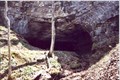
in Cave Entrances (Natural) two relatively large caves, as well as several small nooks and crannies, nestled along massive limestone bluffs overlooking three creeks (just south of Columbia, Missouri) posted by:  mlf920 mlf920 location: Missouri date approved: 04/17/2007 last visited: 12/24/2015 |
 view gallery view gallery N12.1 km N12.1 km
|  The 21st Annual Show-Me Mopar Fest - Columbia MO The 21st Annual Show-Me Mopar Fest - Columbia MO
in Hot Rod Hangouts and Car Shows The 21st Annual Show-Me Mopar Fest - Columbia MO posted by:  kJfishman kJfishman location: Missouri date approved: 07/29/2008 last visited: 06/15/2008 |
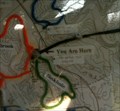
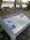
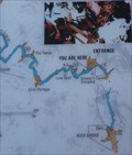 view gallery view galleryNW12.2 km |  You Are Here - Devil's Ice Box - Columbia, Mo You Are Here - Devil's Ice Box - Columbia, Mo
in 'You Are Here' Maps "You are Here" on platform above Devil's Ice Box in Rock Bridge Memorial Park. posted by: trailhound1 location: Missouri date approved: 11/30/2011 last visited: 12/24/2015 |
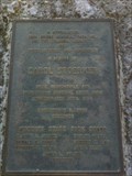 view gallery view galleryNW12.6 km |  Carol Stoerker Memorial - Rock Bridge Memorial State Park, Columbia, Mo Carol Stoerker Memorial - Rock Bridge Memorial State Park, Columbia, Mo
in Citizen Memorials A plaque dedicated in memorial of Carol Stoerker located at Rock Bridge Memorial State Park. posted by: trailhound1 location: Missouri date approved: 11/28/2011 last visited: 07/06/2012 |
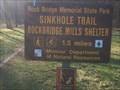 view gallery view galleryNW12.6 km |  Sinkhole Trailhead #1 - Rock Bridge Memorial Park Sinkhole Trailhead #1 - Rock Bridge Memorial Park
in Hiking and walking trailheads Trailhead #1 for the Sinkhole Trail at Rock Bridge Memorial State Park in Columbia, Mo. posted by: trailhound1 location: Missouri date approved: 11/27/2011 last visited: 07/06/2012 |
 view gallery view galleryNW12.6 km | Devil's Ice Box Trailhead - Rock Bridge Memorial State Park in Hiking and walking trailheads Trailhead for the Devil's Ice Box Trail at Rock Bridge Memorial State Park in Columbia, Mo. posted by: trailhound1 location: Missouri date approved: 11/27/2011 last visited: 11/18/2023 |
 view gallery view galleryNW12.6 km | You Are Here - Rock Bridge Memorial State Park - Columbia, Mo in 'You Are Here' Maps "You are Here" on trail map of Rock Bridge Memorial Park. posted by: trailhound1 location: Missouri date approved: 11/26/2011 last visited: 05/26/2015 |
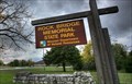 view gallery view galleryNW12.6 km |  Rock Bridge Memorial State Park - Columbia, Mo Rock Bridge Memorial State Park - Columbia, Mo
in State/Provincial Parks Rock Bridge Memorial State Park contains a wide diversity of natural and cultural resources to explore. Some of Missouri’s finest examples of karst topography, restored grasslands, forests and streams rest within park boundaries. posted by: trailhound1 location: Missouri date approved: 11/28/2011 last visited: 11/18/2023 |
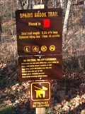 view gallery view galleryNW12.6 km | Spring Brook Trailhead #2 - Rock Bridge Memorial Park in Hiking and walking trailheads Trailhead #2 for the Spring Brook Trail at Rock Bridge Memorial State Park in Columbia, Mo. posted by: trailhound1 location: Missouri date approved: 11/28/2011 last visited: 11/18/2023 |
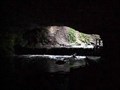 view gallery view galleryNW13.7 km | Connor's/Icebox Cave (Rock Bridge Memorial State Park) in Cave Entrances (Natural) Beatuful state park w/numerous karst features, including caves, a natural bridge, sinkholes, and a small spring posted by: mlf920 location: Missouri date approved: 04/17/2007 last visited: 08/06/2011 |
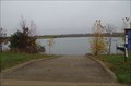 view gallery view galleryN13.8 km |  Perry Phillips Lake - Columbia MO Perry Phillips Lake - Columbia MO
in Canoe/Kayak Trips Perry Phillips Lake is a 40 acre lake in Columbia MO. The lake is owned by the Columbia Parks Department and maintained by the Missouri Conservation Department. posted by: kJfishman location: Missouri date approved: 11/12/2023 last visited: never |
 view gallery view galleryN13.8 km |  Perry Phillips Lake - Columbia MO Perry Phillips Lake - Columbia MO
in Boat Ramps Boat Ramp Perry Phillips Lake. posted by: kJfishman location: Missouri date approved: 11/08/2023 last visited: never |
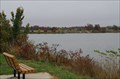 view gallery view galleryN13.8 km |  Perry Phillips Lake - Columbia MO Perry Phillips Lake - Columbia MO
in Fishing Holes Perry Phillips Lake is a 40 acre lake in Columbia MO. posted by: kJfishman location: Missouri date approved: 10/28/2023 last visited: never |
 view gallery view gallery S14.8 km S14.8 km
|  Lewis & Clark National Historic Trail signage near Claysville Lewis & Clark National Historic Trail signage near Claysville
in Lewis and Clark Trail A portion of the Katy Trail State Park trail is also designated as a part of the Lewis & Clark Historic Trail. Near Claysville the trail meets the Missouri River. The signage points out the Lewis & Clark campsite of June 4, 1804 across the river. posted by: Carpe Diem59 location: Missouri date approved: 09/09/2008 last visited: never |
 view gallery view galleryNW15.1 km |  Bethel Church - Columbia, Missouri Bethel Church - Columbia, Missouri
in This Old Church Historic baptist church located in Columbia, Missouri posted by:  BruceS BruceS location: Missouri date approved: 04/22/2008 last visited: never |
 view gallery view galleryNW15.1 km |  Bethel Church and Cemetery - Columbia, Missouri Bethel Church and Cemetery - Columbia, Missouri
in Churchyard Cemeteries Historic church and cemetery located on southwest side of Columbia, Missouri.
posted by: BruceS location: Missouri date approved: 04/23/2008 last visited: never |
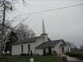 view gallery view galleryNW15.1 km |  Bethel Church - Columbia, MO Bethel Church - Columbia, MO
in Baptist Churches Historic Baptist church located in Columbia, Missouri posted by: BruceS location: Missouri date approved: 09/23/2008 last visited: never |
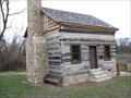 view gallery view galleryN15.1 km |  "Pop" Collins Cabin - Columbia, Missouri "Pop" Collins Cabin - Columbia, Missouri
in Pre-Victorian Historic Homes Old log home built by early settler in Columbia, Missouri. posted by: BruceS location: Missouri date approved: 04/27/2008 last visited: never |
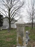
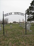 view gallery view galleryNW15.1 km |  Hickam Cemetery - Columbia, Missouri Hickam Cemetery - Columbia, Missouri
in Worldwide Cemeteries Hickam Cemetery is located adjacent to Bethel Church on southwest side of Columbia.
posted by: BruceS location: Missouri date approved: 04/23/2008 last visited: never |
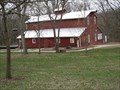 view gallery view galleryN15.3 km |  Maplewood Barn - Columbia, Missouri Maplewood Barn - Columbia, Missouri
in Barns The Maplewood barn is a large hay barn located on the former Maplewood farm on south side of Columbia.
posted by: BruceS location: Missouri date approved: 04/21/2008 last visited: 09/30/2010 |
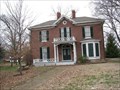 view gallery view galleryN15.3 km |  Maplewood - Columbia, Missouri Maplewood - Columbia, Missouri
in U.S. National Register of Historic Places Historic farm house in Columbia, Missouri.
posted by: BruceS location: Missouri date approved: 04/22/2008 last visited: 01/26/2009 |
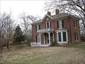 view gallery view galleryN15.3 km |  Maplewood - Columbia, Missouri Maplewood - Columbia, Missouri
in Wikipedia Entries Historic farm house in Columbia, Missouri. posted by: BruceS location: Missouri date approved: 01/19/2010 last visited: never |
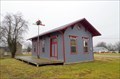 view gallery view gallery E16.3 km E16.3 km
|  New Bloomfield Railroad Depot - New Bloomfield MO New Bloomfield Railroad Depot - New Bloomfield MO
in Train Stations/Depots The New Bloomfield Railroad Depot in New Bloomfield MO was relocated to this location and converted into a home. At some time fairly recently must have been torn down and this replica built posted by: kJfishman location: Missouri date approved: 01/02/2019 last visited: never |
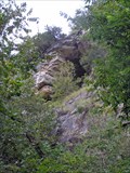 view gallery view galleryNW17.1 km | Pierced Rock Natural Bridge near McBaine, Missouri in Natural Arches The pierced rock natural arch in the Burlington limestone bluffs above today's Katy Trail was noted in 1804 by the Lewis & Clark expedition. It was observable from the river then. The course of the river has changed,but not the landmark. posted by: Carpe Diem59 location: Missouri date approved: 10/21/2010 last visited: 10/14/2015 |
 view gallery view galleryNW17.1 km | Pierced Rock Landmark near McBaine, Missouri in Lewis and Clark Trail On June 6,1804 Lewis & Clark passed by this landmark on the Missouri River named earlier by the French. Though the river's course has changed,this historic natural arch in the high bluffs remains well preserved-- as it looks down on the Katy Trail. posted by: Carpe Diem59 location: Missouri date approved: 10/01/2010 last visited: 10/14/2015 |
|