 view gallery view gallery SW6.4 km SW6.4 km
|   Windsor, Clinton County, Missouri Windsor, Clinton County, Missouri
in Human Migration Monuments This marker is actually located at the KATY Trail trailhead in Windsor. Please view the photo gallery, much additional history and detailed photos highlight this marker. posted by:  YoSam. YoSam. location: Missouri date approved: 04/16/2020 last visited: never |
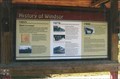
 view gallery view gallerySW6.4 km |  History of Windsor - 1855 to 1999 - Windsor, MO History of Windsor - 1855 to 1999 - Windsor, MO
in Timelines This marker is actually located at the KATY Trail trailhead in Windsor. Please view the photo gallery, much additional history and detailed photos highlight this marker. posted by: YoSam. location: Missouri date approved: 06/01/2015 last visited: never |
 view gallery view gallerySW6.4 km |  LAST - Train to Leave Windsor, Missouri LAST - Train to Leave Windsor, Missouri
in Last of its Kind This marker is actually located at the KATY Trail trailhead in Windsor. Please view the photo gallery, much additional history and detailed photos highlight this marker. posted by: YoSam. location: Missouri date approved: 04/10/2020 last visited: never |
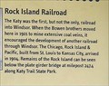 view gallery view gallerySW6.4 km |  FIRST - Railroad & Platted - Windsor, MO FIRST - Railroad & Platted - Windsor, MO
in First of its Kind This marker is actually located at the KATY Trail trailhead in Windsor. Please view the photo gallery, much additional history and detailed photos highlight this marker. posted by: YoSam. location: Missouri date approved: 04/10/2020 last visited: never |
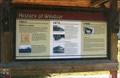 view gallery view gallerySW6.4 km |  History of Windsor - Windsor, MO History of Windsor - Windsor, MO
in Missouri Historical Markers This marker is actually located at the KATY Trail trailhead in Windsor. Please view the photo gallery, much additional history and detailed photos highlight this marker. posted by: YoSam. location: Missouri date approved: 05/13/2014 last visited: never |
 view gallery view gallerySW6.6 km |  Wheel of What Purpose? ~ Windsor, MO Wheel of What Purpose? ~ Windsor, MO
in Wagon Wheels Holding the wall up? posted by: YoSam. location: Missouri date approved: 05/14/2014 last visited: never |
 view gallery view gallerySW6.6 km |  Windsor, Missouri Windsor, Missouri
in Wikipedia Entries Mainly in Henry County this city spills over into a part of Pettis County. posted by: YoSam. location: Missouri date approved: 03/24/2016 last visited: never |
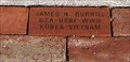 view gallery view gallerySW6.6 km |  Our Flag Veterans Memorial - Windsor, MO Our Flag Veterans Memorial - Windsor, MO
in Donated Engraved Bricks and Pavers Best I can determine, this was a local historical society memorial, and sold the bricks to help finance it. posted by: YoSam. location: Missouri date approved: 07/06/2014 last visited: never |
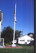 view gallery view gallerySW6.6 km |  Our Flag Veterans Memorial, Windsor, MO Our Flag Veterans Memorial, Windsor, MO
in Non-Specific Veteran Memorials "...Our Flag Was Still There" posted by: YoSam. location: Missouri date approved: 05/09/2008 last visited: never |
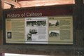
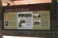 view gallery view gallerySW17.7 km | History of Calhoun - 1835 to 1999 - Calhoun, MO in Timelines From being the first town in the county, to being pushed aside for county seat, to a state park replacing the railroad. posted by: YoSam. location: Missouri date approved: 05/31/2015 last visited: never |
 view gallery view gallerySW17.7 km | Calhoun, Henry County, Missouri in Human Migration Monuments The potters, the railroad, those who made the county grow...oldest town in county...From being the first town in the county, to being pushed aside for county seat, to a state park replacing the railroad. posted by: YoSam. location: Missouri date approved: 02/04/2020 last visited: never |
 view gallery view gallerySW17.7 km | FIRST - Town in County - Calhoun, MO in First of its Kind also first house....sad history of boom and bust... posted by: YoSam. location: Missouri date approved: 01/19/2020 last visited: never |
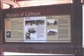 view gallery view gallerySW17.7 km | History of Calhoun - Calhoun, MO in Missouri Historical Markers From being the first town in the county, to being pushed aside for county seat, to a state park replacing the railroad. posted by: YoSam. location: Missouri date approved: 05/03/2008 last visited: 09/25/2007 |
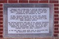
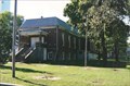
 view gallery view gallerySW17.9 km |  Old City Hall - 1922 - Calhoun, MO Old City Hall - 1922 - Calhoun, MO
in Dated Architectural Structures Multifarious Name and date incised in the front steps... posted by: YoSam. location: Missouri date approved: 02/03/2020 last visited: never |
 view gallery view gallerySW17.9 km | Calhoun - Calhoun, MO in Missouri Historical Markers Local marker of small town. Was big in the pottery business. posted by: YoSam. location: Missouri date approved: 05/02/2008 last visited: 09/12/2010 |
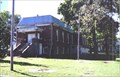 view gallery view gallerySW17.9 km |  Calhoun, Missouri Calhoun, Missouri
in City and Town Halls Once proud city hall, now a community center, and the lawn is a village park. posted by: YoSam. location: Missouri date approved: 05/04/2008 last visited: 09/12/2010 |
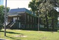 view gallery view gallerySW17.9 km | Calhoun, Missouri in Wikipedia Entries Once proud city hall, now a community center, and the lawn is a village park. posted by: YoSam. location: Missouri date approved: 03/24/2016 last visited: never |
 view gallery view gallerySW17.9 km |  Calhoun, Missouri Calhoun, Missouri
in People-Named Places Oldest city in the county, snubbed for county seat, named for SC Senator... posted by: YoSam. location: Missouri date approved: 02/01/2020 last visited: never |
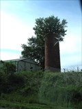 view gallery view gallery N20.8 km N20.8 km
|  Silo with tree, Knob Noster, MO Silo with tree, Knob Noster, MO
in Solitary Silos This silo, with a captured tree, was seen on Hwy 50 near State Rd FF, between Knob Noster and La Monte, Missouri. posted by: Queens Blessing location: Missouri date approved: 06/20/2011 last visited: 09/02/2013 |
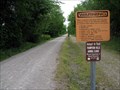 view gallery view gallery NE22.2 km NE22.2 km
|  Katy Trail State Park, Sedalia, Missouri Katy Trail State Park, Sedalia, Missouri
in Rails to Trails This trailhead of the 240-mile long KATY Trail is in Sedalia, Missouri. posted by: Queens Blessing location: Missouri date approved: 06/25/2011 last visited: 09/15/2012 |
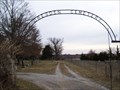
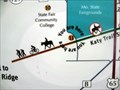 view gallery view galleryNE22.2 km |  Katy Trail State Park, Sedalia, Missouri Katy Trail State Park, Sedalia, Missouri
in 'You Are Here' Maps The KATY trail is a linear trail that replaced the former Missouri-Kansas-Texas Railroad. posted by: Queens Blessing location: Missouri date approved: 06/25/2011 last visited: 09/02/2013 |
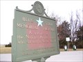 view gallery view galleryNE22.2 km |  U.S. Highway 50, Dresden, MO U.S. Highway 50, Dresden, MO
in Blue Star Memorial Highway Markers Located in the Queen of the Prairies roadside park along U.S. Route 50 near Dresden, Missouri. posted by: Mr. 0 location: Missouri date approved: 01/09/2008 last visited: 11/12/2013 |
 view gallery view galleryNE22.2 km | Sedalia in Missouri Historical Markers Located at Queen of the Prairies roadside park along US 50 just west of Sedalia, MO. posted by: Mr. 0 location: Missouri date approved: 01/08/2008 last visited: never |
 view gallery view galleryNE22.4 km |  Dresden Cemetery / Dresden, MO USA. Dresden Cemetery / Dresden, MO USA.
in Worldwide Cemeteries A medium sized cemetery located in Dresden, Missouri posted by: Mr. 0 location: Missouri date approved: 01/09/2008 last visited: never |
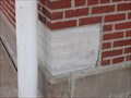 view gallery view galleryNE22.5 km |  1922 Swine Pavilion - State Fair Grounds - Sedalia, Mo. 1922 Swine Pavilion - State Fair Grounds - Sedalia, Mo.
in Dated Buildings and Cornerstones This is a two story red brick pavilion constructed in 1922. This is also the largest show area for the State Fair. posted by: iconions location: Missouri date approved: 01/04/2013 last visited: 08/15/2014 |
|