 view gallery view gallery NW10.1 km NW10.1 km
|   Cove Fort Acquisition Project - Fillmore, UT Cove Fort Acquisition Project - Fillmore, UT
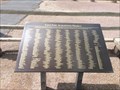
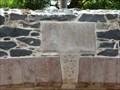
in Utah Historical Markers A maker near the entrance of Cove Fort. posted by:  bluesnote bluesnote location: Utah date approved: 08/29/2014 last visited: 08/25/2022 |
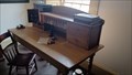 view gallery view galleryNW10.1 km |  Telegraph Key - Cove Fort, UT Telegraph Key - Cove Fort, UT
in Preserved Machines on Public Display The Telegraph Office of historic Cove Fort is on display - at Cove Fort, Utah. posted by: The Snowdog location: Utah date approved: 01/04/2023 last visited: never |
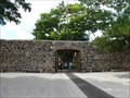
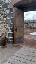 view gallery view galleryNW10.1 km |  Cove Fort Gate - Cove Fort, UT Cove Fort Gate - Cove Fort, UT
in Gates of Distinction The massive gate of Cove Fort were designed to withstand attack - in Cove Fort, Utah. posted by: The Snowdog location: Utah date approved: 03/04/2023 last visited: never |
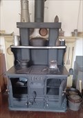 view gallery view galleryNW10.3 km |  Glenwood Double Oven No. 12 - Cove Fort, UT Glenwood Double Oven No. 12 - Cove Fort, UT
in Household Appliances and Presses This massive cast-iron double oven could provide enough food to feed a fort - at Cove Fort, Utah. posted by: The Snowdog location: Utah date approved: 01/02/2023 last visited: never |
 view gallery view galleryNW10.3 km |  1867 - Cove Fort - Fillmore, UT 1867 - Cove Fort - Fillmore, UT
in Dated Buildings and Cornerstones A cornerstone located above the entranceway to Cove Creek Ranch Fort. posted by: bluesnote location: Utah date approved: 11/02/2014 last visited: 01/03/2023 |
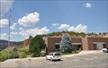
 view gallery view galleryNW10.3 km |  Cove Fort - Fillmore, UT Cove Fort - Fillmore, UT
in Official Local Tourism Attractions A historic fort near the terminus of Interstate 70. posted by: bluesnote location: Utah date approved: 08/27/2014 last visited: 01/03/2023 |
 view gallery view galleryNW10.3 km |  Cove Fort - Fillmore, UT Cove Fort - Fillmore, UT
in LDS Church History Sites A historic fort near the terminus of Interstate 70. posted by: bluesnote location: Utah date approved: 09/08/2014 last visited: 01/03/2023 |
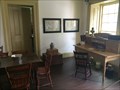 view gallery view galleryNW10.3 km |  Cove Fort, UT 84713 ~ Glimmer and Salisbury Stage Cove Fort, UT 84713 ~ Glimmer and Salisbury Stage
in U.S. Post Offices A historic former post office room at Cove Fort. posted by: bluesnote location: Utah date approved: 08/27/2014 last visited: 01/03/2023 |
 view gallery view galleryNW10.3 km |  Cove Fort - Fillmore, UT Cove Fort - Fillmore, UT
in U.S. National Register of Historic Places Historic Cove Fort was built in 1867 as a waystation for Mormon settlers. posted by:  caverspencer caverspencer location: Utah date approved: 04/03/2007 last visited: 01/03/2023 |
 view gallery view galleryNW10.3 km |  Cove Fort - Fillmore, UT Cove Fort - Fillmore, UT
in History Museums A historic fort near the terminus of Interstate 70. posted by: bluesnote location: Utah date approved: 08/31/2014 last visited: 01/03/2023 |
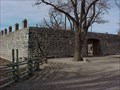 view gallery view galleryNW10.3 km |  Cove Fort - Fillmore, UT Cove Fort - Fillmore, UT
in Historic Forts Historic "COVE FORT" was built in 1867 as a waystation for Mormon settlers. It is located just off Interstate 15 between Beaver and Fillmore, and is one of the last forts built by the Latter-day Saints in the 1800's that is still standing. posted by: caverspencer location: Utah date approved: 02/16/2007 last visited: 01/03/2023 |
 view gallery view galleryNW10.3 km |  Cove Fort - Fillmore, UT Cove Fort - Fillmore, UT
in Wikipedia Entries A historic fort near the terminus of Interstate 70. posted by: bluesnote location: Utah date approved: 08/28/2014 last visited: 01/03/2023 |
 view gallery view gallery E11.3 km E11.3 km
|  Fremont Indian State Park - Utah Fremont Indian State Park - Utah
in State/Provincial Parks Fremont Indian State Park is located at 3820 W Clear Creek Canyon Road near Sevier, Utah. posted by: brwhiz location: Utah date approved: 04/09/2013 last visited: 01/03/2023 |
 view gallery view galleryE11.3 km |  Fremont Indian State Park Visitor Center Fremont Indian State Park Visitor Center
in Ranger Stations This Ranger Station is located at 3820 W Clear Creek Canyon Road near Sevier, Utah. posted by: brwhiz location: Utah date approved: 03/13/2013 last visited: 01/03/2023 |
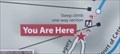 view gallery view galleryE12.2 km |  You Are Here - Court of Ceremonies Trail - Sevier, UT You Are Here - Court of Ceremonies Trail - Sevier, UT
in 'You Are Here' Maps This You-Are-Here map is your guide to the trails of Freemont Indian State Park - in Sevier, Utah. posted by: The Snowdog location: Utah date approved: 01/03/2023 last visited: never |
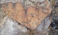 view gallery view galleryE12.2 km |  Freemont Indian Pictographs - Freemont Indian State Park, Sevier, UT Freemont Indian Pictographs - Freemont Indian State Park, Sevier, UT
in Pictographs This Freemont Indian pictorgaph is on displahy outside the Visitors Center of Freemont Indian State Park - in Sevier, Utah. posted by: The Snowdog location: Utah date approved: 01/28/2023 last visited: never |
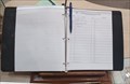 view gallery view galleryE12.2 km |  Freemont Indian State Park Guest Book - Sevier, UT Freemont Indian State Park Guest Book - Sevier, UT
in Guest Books The guest book for Freemont Indian State Park is at the desk in the Visitors Center - in Sevier, Utah. posted by: The Snowdog location: Utah date approved: 01/03/2023 last visited: never |
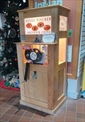 view gallery view galleryE12.2 km |  Freemont Indian State Park Penny Smasher - Sevier, UT Freemont Indian State Park Penny Smasher - Sevier, UT
in Penny Smashers This Penny Smasher is just inside the entrance of the Freemont Indian State Park Visitors Center - in Sevier, Utah. posted by: The Snowdog location: Utah date approved: 01/04/2023 last visited: never |
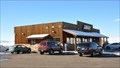 view gallery view galleryNW12.6 km |  Cove Fort Rest Area Cove Fort Rest Area
in Highway Rest Areas This Highway Rest Area is located on the southwest side of Utah Highway 161 just east of Interstate Highway Exit 135 north of Beaver, Utah. posted by: brwhiz location: Utah date approved: 03/30/2013 last visited: never |
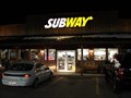 view gallery view galleryNW12.7 km |  Subway - Route 161 - Fillmore, UT Subway - Route 161 - Fillmore, UT
in Subway Restaurants Near Historic Cove Fort, Utah. posted by: JacobBarlow location: Utah date approved: 04/02/2007 last visited: 01/04/2011 |
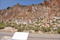 view gallery view galleryE12.9 km | The Arch of Art in Pictographs These Pictographs are located on the north side of Clear Creek Canyon Road, a short distance east of Fremont Indian State Park Museum and Visitor Center between Sevier and Marysvale, Utah. posted by: brwhiz location: Utah date approved: 03/25/2013 last visited: never |
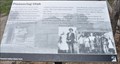 view gallery view galleryE13.2 km | Pioneering Utah in Utah Historical Markers This Historical Marker is located on the south side of Clear Creek Canyon Road, just west of Sam Stowe Canyon Road and about 0.6 miles east of the Fremont Indian State Park Visitor Center near Sevier, Utah. posted by: brwhiz location: Utah date approved: 03/13/2013 last visited: never |
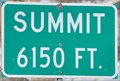 view gallery view galleryNW14 km |  Interstate 15 Northbound ~ Cove Fort Dog Valley Pass, Elevation 6150 feet Interstate 15 Northbound ~ Cove Fort Dog Valley Pass, Elevation 6150 feet
in Elevation Signs One of several summits over 6000 feet that you traverse as you travel Interstate 15 north from St. George to Salt Lake City. This side of the Interstate is apparently 10 feet lower than the southbound side. posted by: brwhiz location: Utah date approved: 06/08/2011 last visited: never |
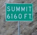 view gallery view galleryNW14.2 km | Interstate 15 Southbound - Cove Fort Dog Valley Pass, 6160 feet in Elevation Signs One of several summits over 6000 feet that you traverse as you travel Interstate 15 south from Salt Lake City to St. George. posted by: brwhiz location: Utah date approved: 03/18/2011 last visited: never |
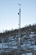 view gallery view galleryNW14.3 km |  Cove Fort Summit Remote-Reporting Weather Station Cove Fort Summit Remote-Reporting Weather Station
in Weather Stations This remote-reporting weather station is located on the west side of Interstate Highway 15 at the summit located several miles north of the junction with Interstate Highway 70. posted by: brwhiz location: Utah date approved: 04/02/2013 last visited: never |
|