 view gallery view gallery W0.3 km W0.3 km
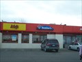
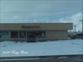
|   Arby's - McCulloch Blvd. - Pueblo West, CO Arby's - McCulloch Blvd. - Pueblo West, CO
in Arby's Restaurants Shares building with Domino's and Shell quick stop. posted by:  mr.volkswagen mr.volkswagen location: Colorado date approved: 02/17/2009 last visited: never |
 view gallery view galleryW0.3 km |  Domino's McCulloch Blvd. - Pueblo West, CO Domino's McCulloch Blvd. - Pueblo West, CO
in Domino's Pizza This Domino's is shared with a Shell gas station and Arby's. posted by: mr.volkswagen location: Colorado date approved: 02/16/2009 last visited: never |
 view gallery view gallery NW0.5 km NW0.5 km
|  Taco Bell - McCulloch Blvd. - Pueblo West, CO Taco Bell - McCulloch Blvd. - Pueblo West, CO
in Taco Bell Restaurants Located at Highway 50 and McCulloch Blvd. posted by: mr.volkswagen location: Colorado date approved: 02/16/2009 last visited: never |
 view gallery view gallery E3.4 km E3.4 km
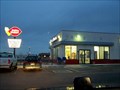
|  Dairy Queen - Pueblo West, CO Dairy Queen - Pueblo West, CO
in Dairy Queen Restaurants Located in Pueblo West, Colorado. posted by: mr.volkswagen location: Colorado date approved: 04/13/2008 last visited: never |
 view gallery view gallery NE4.5 km NE4.5 km
|  Pueblo West Firehouse Pueblo West Firehouse
in Firehouses Pueblo West Firehouse posted by:  rastus76nicolette18 rastus76nicolette18 location: Colorado date approved: 04/22/2012 last visited: 03/13/2016 |
 view gallery view gallery S7.1 km S7.1 km
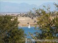
|  Pueblo Dam - Pueblo, Colorado Pueblo Dam - Pueblo, Colorado
in Satellite Imagery Oddities While this project's primary purpose is water storage, it provides many recreational opportunities for residents and visitors. posted by: Outspoken1 location: Colorado date approved: 08/23/2015 last visited: never |
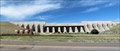
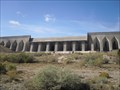 view gallery view galleryS7.1 km |  Lake Pueblo Dam - Pueblo, Colorado Lake Pueblo Dam - Pueblo, Colorado
in Water Dams A water dam constructed in 1970-1975 on the Arkansas River near Pueblo Colorado. 250 feet High, Crest length 10,230 feet. Storage Cap: 357,000 acre feet. posted by: PersonsMD location: Colorado date approved: 10/28/2009 last visited: 08/08/2015 |
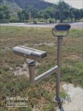 view gallery view galleryS7.2 km |  Vineyard Dr. Binoculars - Pueblo, CO Vineyard Dr. Binoculars - Pueblo, CO
in Coin-Op Binoculars Located off Vineyard Dr. at Pueblo Reservoir State Park. posted by: mr.volkswagen location: Colorado date approved: 09/12/2017 last visited: 09/12/2017 |
 view gallery view galleryS7.7 km |  Feed the Fish - Pueblo Hatchery - Pueblo, CO Feed the Fish - Pueblo Hatchery - Pueblo, CO
in Feeding the Animals This hatchery is the only both cold and warm water hatchery in Colorado. But visit during the weekdays - weekends the tours are 'self guided'. posted by: Outspoken1 location: Colorado date approved: 08/13/2015 last visited: never |
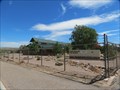 view gallery view galleryS7.7 km |  Pueblo Hatchery - Pueblo, CO Pueblo Hatchery - Pueblo, CO
in Fish Hatcheries This hatchery is the only both cold and warm water hatchery in Colorado. But visit during the weekdays - weekends the tours are 'self guided'. posted by: Outspoken1 location: Colorado date approved: 08/13/2015 last visited: never |
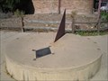 view gallery view galleryS8.7 km |  Lake Pueblo Sundial, Pueblo, Colorado Lake Pueblo Sundial, Pueblo, Colorado
in Sundials A large sundial located at the entrance of the Lake Pueblo visitor center. posted by: PersonsMD location: Colorado date approved: 10/31/2009 last visited: 06/23/2017 |
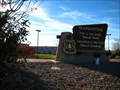 view gallery view galleryE8.9 km |  Pike and San Isabel National Forests, Cimmaron and Comanche National Grasslands: Headquarters - Pueblo, CO Pike and San Isabel National Forests, Cimmaron and Comanche National Grasslands: Headquarters - Pueblo, CO
in Ranger Stations The PSICC is nearly 3 million acres and is perhaps the most diverse unit throughout the five-state Rocky Mountain Region. All four of the separate Forests and Grasslands are headquartered at this location. posted by: CerealBoxMonsters location: Colorado date approved: 11/15/2010 last visited: never |
 view gallery view gallery SE9.3 km SE9.3 km
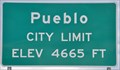
|  Pueblo, Colorado ~ Elevation 4665 Feet Pueblo, Colorado ~ Elevation 4665 Feet
in Elevation Signs This Elevation Sign is located at the northwestern city limits of Pueblo on Pueblo Blvd. posted by: brwhiz location: Colorado date approved: 04/02/2013 last visited: never |
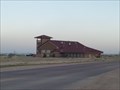
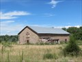
 view gallery view gallerySE9.3 km |  Goodnight Barn - Pueblo, CO Goodnight Barn - Pueblo, CO
in Barns While the area is closed to visitors (as of 2015), you can still easily visit this historic barn from the shoulder of the road. posted by: Outspoken1 location: Colorado date approved: 08/10/2015 last visited: never |
 view gallery view gallerySE9.3 km |  Goodnight Barn - Peublo, CO Goodnight Barn - Peublo, CO
in U.S. National Register of Historic Places While the area is closed to visitors (as of 2015), you can still easily visit this historic barn from the shoulder of the road. posted by: Outspoken1 location: Colorado date approved: 08/10/2015 last visited: never |
 view gallery view gallerySE9.3 km |  Goodnight Barn - Pueblo, CO Goodnight Barn - Pueblo, CO
in Colorado Historical Markers While the area is closed to visitors (as of 2015), you can still easily visit this historic barn from the shoulder of the road. posted by: Outspoken1 location: Colorado date approved: 08/10/2015 last visited: never |
 view gallery view galleryE9.5 km |  Quizno's - Baltimore Ave. - Pueblo, CO Quizno's - Baltimore Ave. - Pueblo, CO
in Quiznos Located at the corner of US Hwy. 50 and Baltimore Ave. posted by: mr.volkswagen location: Colorado date approved: 12/09/2009 last visited: never |
 view gallery view galleryS9.5 km |  Lake Pueblo State Park - Pueblo, CO Lake Pueblo State Park - Pueblo, CO
in State/Provincial Parks Lake Pueblo, rated a fishing “hot spot,” provides 4,500 surface acres of water, 60 miles of shoreline and almost 10,000 acres of land. Along with the sunny days and a mild climate, visitors quickly learn that one day is not enough. posted by: ArmyFamily4 location: Colorado date approved: 03/22/2011 last visited: 08/08/2015 |
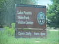 view gallery view galleryS9.5 km |  Lake Pueblo State Park - Pueblo, CO Lake Pueblo State Park - Pueblo, CO
in Official Local Tourism Attractions Lake Pueblo, rated a fishing “hot spot,” provides 4,500 surface acres of water, 60 miles of shoreline and almost 10,000 acres of land. Along with the sunny days and a mild climate, visitors quickly learn that one day is not enough. posted by: Outspoken1 location: Colorado date approved: 08/26/2015 last visited: never |
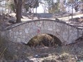 view gallery view gallerySE10.3 km |  City Park Bridge - Pueblo, CO City Park Bridge - Pueblo, CO
in Stone Bridges Located just of Pueblo Blvd. posted by: mr.volkswagen location: Colorado date approved: 02/02/2009 last visited: 08/08/2015 |
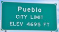 view gallery view galleryE10.6 km | Pueblo, Colorado ~ Elevation 4695 Feet in Elevation Signs This Elevation Sign is located at the northern city limits of Pueblo on Interstate Highway 25. posted by: brwhiz location: Colorado date approved: 09/06/2012 last visited: never |
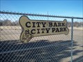 view gallery view gallerySE10.6 km |  City Bark at City Park, Pueblo, CO City Bark at City Park, Pueblo, CO
in Off-Leash Dog Areas The City Bark is located in the southwest corner of Pueblo City Park. posted by: condor1 location: Colorado date approved: 01/25/2011 last visited: 03/01/2016 |
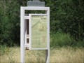
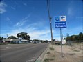 view gallery view gallerySE10.6 km |  Frontier Pathways - Pueblo, CO Frontier Pathways - Pueblo, CO
in National Scenic Byways Frontier Pathways - Thousands left their footsteps in this much traveled corridor-first the Ute Indians, then Spanish and American explorers, and finally traders, fur trappers, homesteaders, ranchers, and gold prospectors. posted by: Outspoken1 location: Colorado date approved: 08/19/2015 last visited: never |
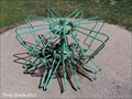 view gallery view gallerySE10.6 km |  Pueblo City Park Bicycle Tender - Pueblo, CO Pueblo City Park Bicycle Tender - Pueblo, CO
in Bicycle Tenders This Bicycle tender sits in front of the Pueblo City Parks Admin Building in Pueblo City Park. posted by: mr.volkswagen location: Colorado date approved: 06/16/2011 last visited: 03/01/2016 |
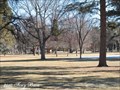 view gallery view gallerySE10.6 km |  Pueblo City Park - Pueblo, CO Pueblo City Park - Pueblo, CO
in Municipal Parks and Plazas This is a very busy place in the summer months. lots for the family to enjoy. posted by: mr.volkswagen location: Colorado date approved: 03/01/2010 last visited: 03/01/2016 |
|