 view gallery view gallery E1 km E1 km
|   FIRST-- Economic Recovery Project in the U.S. FIRST-- Economic Recovery Project in the U.S.
in Superlatives The Osage River Bridge on Route 17 near Tuscumbia, Missouri was the nation's first project to start construction under the American Recovery and Reinvestment Act signed by the President in 2009. The new bridge was opened to traffic on August 16, 2010 posted by:  Carpe Diem59 Carpe Diem59 location: Missouri date approved: 08/21/2010 last visited: never |
 view gallery view gallery NW12.2 km NW12.2 km
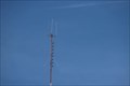
|  KZWV-FM 101.9-FM - Eldon MO USA KZWV-FM 101.9-FM - Eldon MO USA
in Radio and Television Transmitter Towers The FM broadcast antenna for KZWV-FM 101.9 In Eldon MO USA posted by:  Benchmark Blasterz Benchmark Blasterz location: Missouri date approved: 03/23/2023 last visited: 03/25/2023 |
 view gallery view galleryNW12.4 km |  "Missouri Woman Puts Up Billboard in Response to Confederate Flag" -- Eldon MO USA "Missouri Woman Puts Up Billboard in Response to Confederate Flag" -- Eldon MO USA
in News Article Locations Competing messages of racial equality and racism along the US 54 in Eldon Missouri were the subject of a story from local ABC affiliate KMIZ-17 posted by: Benchmark Blasterz location: Missouri date approved: 03/23/2023 last visited: 03/25/2023 |
 view gallery view galleryNW13.4 km |  EARTH ANGELZ CLUB - Neons EARTH ANGELZ CLUB - Neons
in Neon Signs Earth Angelz Gentleman's Club Neons Eldon, Missouri posted by: GEO*Trailblazer 1 location: Missouri date approved: 04/07/2008 last visited: 04/07/2008 |
 view gallery view gallery W14.5 km W14.5 km
|  Bagnell Dam Scenic Overlook Bagnell Dam Scenic Overlook
in Water Dams Scenic overlook of the Bagnell Dam just outside of Osage Beach Missouri. posted by: singleshot54 location: Missouri date approved: 11/24/2014 last visited: never |
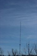 view gallery view gallery SW14.6 km SW14.6 km
| KRMS-FM 93.3, K254BE (KRMS-FM) 98.7, K227DJ (KRMS-AM) 103.3, K285ER (KRMS-FM) 104.9 - Osage Lake MO USA in Radio and Television Transmitter Towers This FM radio broadcast tower posts hosts three low-power FM repeaters and one FM broadcast antenna for KRMS-AM and KRMS-FM 93.5 along the US 54 at Osage Beach, Missouri posted by: Benchmark Blasterz location: Missouri date approved: 03/23/2023 last visited: 03/25/2023 |
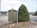 view gallery view galleryW15.3 km |  Bagnell Dam - Lakeside, MO Bagnell Dam - Lakeside, MO
in Missouri Historical Markers Quick history of the Dam and surrounding area going back to the Lewis and Clark expedition. posted by: BrrrMo location: Missouri date approved: 03/04/2009 last visited: 09/17/2013 |
 view gallery view gallery SE15.6 km SE15.6 km
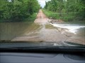
|  Ponder Slab, Iberia, Missouri Ponder Slab, Iberia, Missouri
in Bridgeless Water Crossings This bridgeless water crossing is located near Iberia, Missouri. posted by: Queens Blessing location: Missouri date approved: 06/26/2011 last visited: 09/15/2012 |
 view gallery view galleryW15.6 km |  Elevated Boats Lake Ozark, MO Elevated Boats Lake Ozark, MO
in Elevated Everyday Objects TWO elevated boats at Lake Ozark, MO. within in one mile of each other. posted by: BrrrMo location: Missouri date approved: 03/05/2009 last visited: 09/19/2013 |
 view gallery view galleryW16.1 km |  The Leatherman Shop Penny Smasher The Leatherman Shop Penny Smasher
in Penny Smashers This single-design electric Penny Smasher is in The Leatherman Shop at 1446 Bagnell Dam Blvd in Lake Ozark, Missouri. posted by: brwhiz location: Missouri date approved: 07/01/2012 last visited: never |
 view gallery view galleryW16.3 km |  Grandma Predicts ~ Lake Ozark, Missouri Grandma Predicts ~ Lake Ozark, Missouri
in Coin-Operated Fortune Telling Machines Grandma will tell your fortune at 1482 Bagnell Dam Blvd in Lake Ozark, Missouri. posted by: brwhiz location: Missouri date approved: 06/06/2012 last visited: never |
 view gallery view galleryW16.3 km | Dogpatch Store Penny Smasher in Penny Smashers This single-design electric Penny Smasher is in the Dogpatch Store at 1482 Bagnell Dam Blvd in Lake Ozark, Missouri. posted by: brwhiz location: Missouri date approved: 07/01/2012 last visited: never |
 view gallery view galleryW16.3 km |  Crazy-looking guy on Bagnell Dam Strip Crazy-looking guy on Bagnell Dam Strip
in Highway Giants - Muffler Men Crazy-looking bucktoothed guy holding a lantern on Lake of the Ozark's Bagnell Dam Strip. posted by: fishallnight location: Missouri date approved: 03/11/2008 last visited: 09/16/2013 |
 view gallery view galleryW16.3 km | Bagnell Dam Strip Indian Chief in Highway Giants - Muffler Men Indian Chief waving at the crazy looking guy across the road. On the Bagnell Dam Strip at Lake of the Ozarks. posted by: fishallnight location: Missouri date approved: 03/11/2008 last visited: 09/16/2013 |
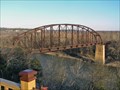 view gallery view gallery NE17.5 km NE17.5 km
|  Osage River Bridge Rock Island Line near St. Elizabeth, MO Osage River Bridge Rock Island Line near St. Elizabeth, MO
in Orphaned Bridges The old Rock Island Line truss railroad bridge still crosses the Osage River near St. Elizabeth on the south bank to Henley on the north bank. posted by: Carpe Diem59 location: Missouri date approved: 12/10/2009 last visited: never |
 view gallery view gallerySW17.7 km | VISTA GRANDE MEXICAN FOOD - Neon in Neon Signs Vista Grande Mexican Food neon Lake of the Ozarks, Missouri posted by: GEO*Trailblazer 1 location: Missouri date approved: 04/07/2008 last visited: 03/20/2014 |
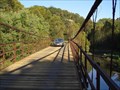 view gallery view gallery S18.2 km S18.2 km
|  Grand Auglaize Swinging Bridge Grand Auglaize Swinging Bridge
in Suspension Bridges This is the longest of five swinging bridges located near lake of the Ozarks at Camdenton, MO. posted by: RGS location: Missouri date approved: 12/22/2006 last visited: 03/16/2022 |
 view gallery view gallerySW20.9 km | PICKLED PETE'S - Neon in Neon Signs Pickled Pete's Neon sign Lake of the Ozarks, Missouri posted by: GEO*Trailblazer 1 location: Missouri date approved: 04/07/2008 last visited: 03/20/2014 |
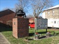 view gallery view gallerySE21.4 km |  Bell of Congregational Church, Iberia, MO Bell of Congregational Church, Iberia, MO
in Bells A cast steel bell, presumably from a former building, stands on a brick and concrete pedestal outside the present building of the Congregational Church. posted by: STLbells location: Missouri date approved: 01/03/2022 last visited: never |
 view gallery view gallerySE23.2 km |  Union Cemetery, Iberia Missouri Union Cemetery, Iberia Missouri
in Worldwide Cemeteries Union Cemetery is located next to Brays Advent Christian Church but is not associated with that church. posted by: Queens Blessing location: Missouri date approved: 06/01/2011 last visited: 09/15/2012 |
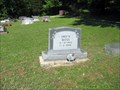 view gallery view gallerySE23.2 km |  103 - Fred R. Moss - Iberia, Missouri 103 - Fred R. Moss - Iberia, Missouri
in Headstones of Centenarians I noticed this headstone and military marker at the Union Cemetery off Hwy 42 in Miller County, Missouri, about 5 miles from Iberia, Missouri. posted by: Queens Blessing location: Missouri date approved: 06/09/2011 last visited: 09/15/2012 |
 view gallery view gallerySW23.2 km |  Ozark Caverns - Lake of the Ozarks Missouri State Park Ozark Caverns - Lake of the Ozarks Missouri State Park
in State Park Passport Locations The Ozark Caverns Visitors Center provides a stamping station for Missouri State Park Passports posted by: cldisme location: Missouri date approved: 06/26/2011 last visited: never |
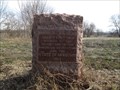 view gallery view galleryS26.2 km | Boone's Lick Road - Head's Fort - 1812 in Missouri Historical Markers A granite monument placed by the Daughters of the American Revolution marking an important stop along the Boone's Lick Road. posted by: Utapao72 location: Missouri date approved: 12/10/2015 last visited: never |
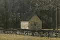
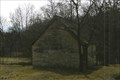 view gallery view gallery N26.4 km N26.4 km
|  Granary - Louis Bruce Farmstead Historic District - Enon, MO Granary - Louis Bruce Farmstead Historic District - Enon, MO
in NRHP Historic Districts - Contributing Buildings The granary and barn are across the hwy from the farm house. The barn is in the woods, with no path to it, so I did not photograph that building. posted by: YoSam. location: Missouri date approved: 02/23/2016 last visited: never |
 view gallery view galleryN26.4 km | Spring House - Louis Bruce Farmstead Historic District - Enon, MO in NRHP Historic Districts - Contributing Buildings Spring house in the NRHP photo has no roof, today it has one. posted by: YoSam. location: Missouri date approved: 02/23/2016 last visited: never |
|