 view gallery view gallery NW2.7 km NW2.7 km
|   Fayette-Scott Counties Boundary Monument on Lemons Mill Pike, KY Fayette-Scott Counties Boundary Monument on Lemons Mill Pike, KY
in U.S. Historic Survey Stones and Monuments Dressed stone with letter 'F' on the Fayette County side and letter 'S' on the Scott County side. Shown as a boundary monument on the Centerville, KY 7.5' topo. posted by:  wuja wuja location: Kentucky date approved: 04/09/2007 last visited: never |
 view gallery view gallery SE2.9 km SE2.9 km
|  Domino Domino
in Animal Memorials Headstone marking the grave of the thoroughbred racer Domino. Located at 3830 Huffman Mill Pike off of Russell Cave Road north of Lexington, KY. posted by:  trailhound1 trailhound1 location: Kentucky date approved: 10/07/2010 last visited: 10/07/2010 |
 view gallery view gallery S3.1 km S3.1 km
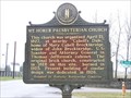
|  Mt. Horeb Presbyterian Church - Lexington, KY Mt. Horeb Presbyterian Church - Lexington, KY
in Presbyterian Churches Mount Horeb Presbyterian Churches located on Fayette County Road 1973 and Mount Horeb Pike. posted by: trailhound1 location: Kentucky date approved: 03/13/2011 last visited: 07/06/2011 |
 view gallery view gallery SW3.2 km SW3.2 km
|  Mount Horeb Sinkhole - Fayette County, KY, US Mount Horeb Sinkhole - Fayette County, KY, US
in Natural Sinkholes Located on Mount Horeb road. posted by: Crazy4horses location: Kentucky date approved: 01/01/2017 last visited: 01/01/2017 |
 view gallery view gallerySW3.4 km |  Wing Commander Wing Commander
in Kentucky Historical Markers Found while caching posted by: geoprof123 location: Kentucky date approved: 07/09/2012 last visited: 07/06/2011 |
 view gallery view gallerySW3.4 km |  Samuel & Susannah Laird Samuel & Susannah Laird
in Out of Place Graves A single obelisk marking the graves of Samuel and Susannah Laird in the courtyard of the Mt. Horeb Presbyterian Church. posted by: trailhound1 location: Kentucky date approved: 03/11/2011 last visited: 03/11/2011 |
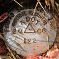
 view gallery view gallerySW3.4 km |  KDOT KY-922 123, Lexington, KY KDOT KY-922 123, Lexington, KY
in U.S. Benchmarks Used in aerial survey for the Newtown Pike (KY-922) widening project. posted by: wuja location: Kentucky date approved: 04/04/2007 last visited: never |
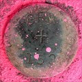
 view gallery view galleryNW3.5 km |  0098 AZI-2, Lexington, KY 0098 AZI-2, Lexington, KY
in Azimuth Benchmarks Azimuth mark #2 for HZ2658 - LFUCG GPS STA 0098 set flush with ground in concrete post. posted by: trailhound1 location: Kentucky date approved: 07/05/2011 last visited: 06/29/2011 |
 view gallery view gallerySW3.5 km | Mt. Horeb Presbyterian Church in Kentucky Historical Markers The original brick church, constructed in 1828 on this site, burned in 1925. Present building of similar design was dedicated in 1926. posted by: BluegrassCache location: Kentucky date approved: 01/13/2008 last visited: 07/06/2011 |
 view gallery view gallerySW3.5 km | GRW 153, Lexington, KY in U.S. Benchmarks An older (1977?) mark along Newtown Pike (KY-922). It is just 5 feet north of LFUCG GPS STA 0074. posted by: wuja location: Kentucky date approved: 02/23/2007 last visited: never |
 view gallery view galleryNW3.5 km | SC9402, Scott County, KY in U.S. Benchmarks Monumented in June 1994. posted by: wuja location: Kentucky date approved: 04/09/2007 last visited: never |
 view gallery view galleryS3.5 km | Maddoxtown in Kentucky Historical Markers A historical marker noting one of many freetowns in central Kentucky, settled by former slaves during the post-Civil War period. Located on Huffman Mill Pike, north of Lexington, Ky off of Russell Cave Road. posted by: trailhound1 location: Kentucky date approved: 10/07/2010 last visited: 12/03/2011 |
 view gallery view gallerySW3.7 km | KDOT KY-922 122, Lexington, KY in U.S. Benchmarks Used in aerial survey for the Newtown Pike (KY-922) widening project. posted by: wuja location: Kentucky date approved: 02/23/2007 last visited: never |
 view gallery view gallerySW3.9 km | KDOT KY-922 121, Lexington, KY in U.S. Benchmarks Used in aerial survey for the Newtown Pike (KY-922) widening project. posted by: wuja location: Kentucky date approved: 02/23/2007 last visited: never |
 view gallery view gallerySW4.2 km | KDOT KY-922 120, Lexington, KY in U.S. Benchmarks Used in aerial survey for the Newtown Pike (KY-922) widening project. posted by: wuja location: Kentucky date approved: 02/23/2007 last visited: never |
 view gallery view galleryS4.2 km | John Bradford in Kentucky Historical Markers Built on this property Flemish bond brick home, "Fairfield," ca. 1785-1800. Earlier a surveyor, Bradford became publisher and editor of Kentucky Gazette, state's first newspaper, printed Aug. 11, 1787. posted by: BluegrassCache location: Kentucky date approved: 01/13/2008 last visited: 12/03/2011 |
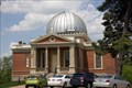 view gallery view gallerySE4.3 km |  Cincinnati Observatory Cincinnati Observatory
in Astronomical Observatories Oldest operational refractor type telescope in the world. posted by: singleshot54 location: Ohio date approved: 05/20/2015 last visited: 10/28/2017 |
 view gallery view gallerySW4.3 km | GRW 152, Lexington, KY in U.S. Benchmarks An older (1977?) mark along Newtown Pike (KY-922). It is just across the road from the new mark KDOT KY-922 119. posted by: wuja location: Kentucky date approved: 02/23/2007 last visited: never |
 view gallery view gallerySW4.3 km | KDOT KY-922 119, Lexington, KY in U.S. Benchmarks Used in aerial survey for the Newtown Pike (KY-922) widening project. posted by: wuja location: Kentucky date approved: 02/23/2007 last visited: never |
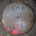 view gallery view gallery E4.7 km E4.7 km
| GRW 155, Lexington, KY in U.S. Benchmarks East of Russell Cave Rd. posted by: wuja location: Kentucky date approved: 03/27/2007 last visited: never |
 view gallery view gallerySW4.7 km |  Southern Lights Holiday Festival- Lexington, KY Southern Lights Holiday Festival- Lexington, KY
in Holiday Displays "Southern Lights" is a nearly three mile drive through thousands of lights reflecting the holiday season and Kentucky treasures like horse-racing. It has been designated a Top Twenty Event by the Southeast Tourism Society.
posted by: BluegrassCache location: Kentucky date approved: 12/19/2007 last visited: 08/15/2011 |
 view gallery view gallerySW4.7 km |  Kentucky Horse Park Campground - Lexington, KY Kentucky Horse Park Campground - Lexington, KY
in Campgrounds A great campground with a store and swimming pool, located just off I-75 near the Kentucky Horsepark this is one of only a couple of campgrounds in the area. However, advance reservations are required and it fills up fast. posted by: BluegrassCache location: Kentucky date approved: 11/02/2007 last visited: 08/15/2011 |
 view gallery view galleryS4.7 km | KDOT KY-922 118, Lexington, KY in U.S. Benchmarks Used in aerial survey for the Newtown Pike (KY-922) widening project. posted by: wuja location: Kentucky date approved: 02/23/2007 last visited: never |
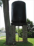 view gallery view gallery W4.7 km W4.7 km
|  Kentucky Horse Park Water Tower - Lexington, KY Kentucky Horse Park Water Tower - Lexington, KY
in Water Towers Old water tower located on the grounds of the Kentucky Horse Park State Park. posted by: linkys location: Kentucky date approved: 09/19/2011 last visited: 05/18/2022 |
 view gallery view galleryW4.8 km |  Kentucky Horse Park Globe - Lexington, KY Kentucky Horse Park Globe - Lexington, KY
in Earth Globes Globe at the Kentucky Horse Park made from what else but horse shoes. posted by: linkys location: Kentucky date approved: 09/19/2011 last visited: never |
|