 view gallery view gallery E9.3 km E9.3 km
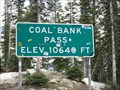
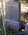
|   Coal Bank Pass - 10,640' Coal Bank Pass - 10,640'
in Elevation Signs Highway 550 between Silverton and Durango, Colorado. posted by:  WR7X WR7X location: Colorado date approved: 04/28/2012 last visited: 07/19/2015 |
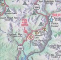 view gallery view galleryE9.3 km |  Coal Bank Pass Summit Coal Bank Pass Summit
in 'You Are Here' Maps You Are Here at the summit of Coal Bank Pass on the San Juan Skyway in southwestern Colorado. posted by: brwhiz location: Colorado date approved: 09/12/2013 last visited: never |
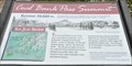 view gallery view galleryE9.3 km | Coal Bank Pass ~ Elevation 10,660 Feet in Elevation Signs This Elevation Sign is at the summit of Coal Bank Pass on US Highway 550 between Silverton and Durango, Colorado. posted by: brwhiz location: Colorado date approved: 04/27/2013 last visited: never |
  SE11.7 km SE11.7 km
|  Durango Mtn resort Colorado Durango Mtn resort Colorado
in Web Cameras Durango co posted by: kingbee location: Colorado date approved: 06/15/2015 last visited: never |
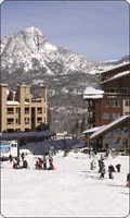 view gallery view gallerySE11.9 km |  Durango Mtn Resort Durango Mtn Resort
in Ski Lodges Durango ski area posted by: kingbee location: Colorado date approved: 09/29/2011 last visited: 09/14/2019 |
 view gallery view gallery W13.7 km W13.7 km
|  Rico, Colorado - Rico, CO Rico, Colorado - Rico, CO
in Colorado Historical Markers The Rico, Colorado historical marker is a bronze plaque mounted on a mine car. posted by: hummerstation location: Colorado date approved: 07/05/2015 last visited: never |
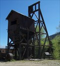 view gallery view galleryW13.7 km |  The Atlantic Cable Mine - Rico, CO The Atlantic Cable Mine - Rico, CO
in Mines The Atlantic Cable Mine headframe and part of the hoist house are located on CO Hwy 145 on the north side of Rico. posted by: hummerstation location: Colorado date approved: 07/07/2015 last visited: never |
 view gallery view galleryW14.5 km |  Rico Cemetery - Rico, CO Rico Cemetery - Rico, CO
in Worldwide Cemeteries The Rico Cemetery lies between CO Hwy 145 and the Dolores River just south of Rico, CO. posted by: hummerstation location: Colorado date approved: 07/06/2015 last visited: never |
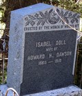 view gallery view galleryW14.5 km |  Isabel Doll Dawson - Rico Cemetery - Rico, CO Isabel Doll Dawson - Rico Cemetery - Rico, CO
in Woodmen of the World Grave Markers/Monuments The Isabel Doll Women of Woodcraft marker is located in Rico Cemetery. posted by: hummerstation location: Colorado date approved: 07/04/2015 last visited: never |
 view gallery view galleryW14.5 km | Emily B. Meredith - Rico Cemetery - Rico, CO in Woodmen of the World Grave Markers/Monuments The Emily B. Meredith Neighbors of Woodcraft marker is located in Rico Cemetery. posted by: hummerstation location: Colorado date approved: 07/06/2015 last visited: never |
 view gallery view gallery N15.9 km N15.9 km
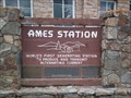
|  Ames Hydroelectric Station Ames Hydroelectric Station
in First of its Kind The Ames Station is the world's first generating station to produce and transmit alternating current. posted by:  krazykatzen krazykatzen location: Colorado date approved: 06/27/2010 last visited: never |
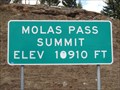 view gallery view galleryE16.1 km | Molas Pass - 10,910' in Elevation Signs Highway 550 between Silverton and Durango, Colorado. posted by: WR7X location: Colorado date approved: 04/28/2012 last visited: 09/12/2019 |
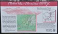 view gallery view galleryE16.1 km | Molas Pass ~ Elevation 10,899 Feet in Elevation Signs This Elevation Sign is at the summit of Molas Pass on US Highway 550 between Silverton and Durango, Colorado. posted by: brwhiz location: Colorado date approved: 04/27/2013 last visited: 09/12/2019 |
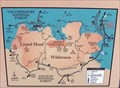 view gallery view galleryN17.7 km | You Are Here - A Wilderness Legacy - Ophir, CO in 'You Are Here' Maps The "A Wilderness Legacy" panel is located on the west side of Colorado Hwy 145 between Lizard Head Pass and Ophir. posted by: hummerstation location: Colorado date approved: 07/05/2015 last visited: never |
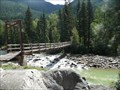 view gallery view gallerySE19.2 km |  D&SNGRR / Needleton Footbridge - San Juan Nat'l Forest, Colorado D&SNGRR / Needleton Footbridge - San Juan Nat'l Forest, Colorado
in Hiking Path Footbridges This wooden footbridge crosses the Anamas River at the Needleton Flagstop "Station" of the Durango & Silverton Narrow Guage Railroad. posted by: PeterNoG location: Colorado date approved: 12/12/2011 last visited: 08/27/2008 |
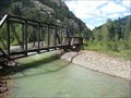 view gallery view galleryE20 km |  Durango-Silverton RR Bridge - Animas Valley CO Durango-Silverton RR Bridge - Animas Valley CO
in Railroad Bridges This Railroad Bridge is a half hour from the Silverton Station on the Durango & Silverton Narrow Gauge Railroad. posted by: PeterNoG location: Colorado date approved: 01/03/2014 last visited: 08/27/2008 |
 view gallery view gallery NE20.1 km NE20.1 km
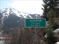
| Silverton, Colorado - 9318' in Elevation Signs The sign is located on northbound Highway 550. posted by: WR7X location: Colorado date approved: 04/29/2012 last visited: 06/04/2015 |
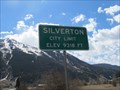 view gallery view galleryNE20.4 km | Silverton, Colorado - 9318' in Elevation Signs This sign is located on southbound Highway 550. posted by: WR7X location: Colorado date approved: 04/29/2012 last visited: 07/14/2015 |
 view gallery view galleryNE20.4 km |  Triangle Convenience Store (Conoco Gas Station) Penny Smasher Triangle Convenience Store (Conoco Gas Station) Penny Smasher
in Penny Smashers This three-design Penny Smasher is in the Triangle Convenience Store (Conoco Gas Station) at 315 Greene Street in Silverton, Colorado. posted by: brwhiz location: Colorado date approved: 10/22/2011 last visited: never |
 view gallery view galleryNE20.6 km | Silverton Chamber of Commerce & Visitors Center Penny Smasher #2 in Penny Smashers This three-design Penny Smasher is the second of two in the Silverton Chamber of Commerce & Visitors Center at 414 Greene Street in Silverton, Colorado posted by: brwhiz location: Colorado date approved: 10/22/2011 last visited: never |
 view gallery view galleryNE20.6 km | Silverton Chamber of Commerce & Visitors Center Penny Smasher #1 in Penny Smashers This three-design Penny Smasher is one of two in the Silverton Chamber of Commerce & Visitors Center at 414 Greene Street in Silverton, Colorado. posted by: brwhiz location: Colorado date approved: 10/22/2011 last visited: never |
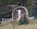 view gallery view galleryNE20.9 km |  Christ of the Mines - Silverton CO Christ of the Mines - Silverton CO
in Roadside Attractions A 12-ton, 16-foot tall statue of Jesus Christ, sits some 500 feet up the slope of Anvil Mountain, north of the town of Silverton. posted by: Don.Morfe location: Colorado date approved: 01/18/2022 last visited: 01/18/2022 |
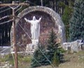 view gallery view galleryNE20.9 km |  Christ of the Mines - Silverton CO Christ of the Mines - Silverton CO
in Statues of Religious Figures A 12-ton, 16-foot tall statue of Jesus Christ, sits some 500 feet up the slope of Anvil Mountain, north of the town of Silverton. posted by: Don.Morfe location: Colorado date approved: 01/18/2022 last visited: 01/18/2022 |
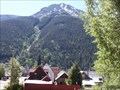 view gallery view galleryNE21.2 km |  Silverton, Colorado Silverton, Colorado
in Ansel Adams Photo Hunt Kendall Mountain forms the backdrop to Silverton, Colorado posted by: cldisme location: Colorado date approved: 06/27/2010 last visited: 07/19/2014 |
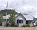 view gallery view galleryNE21.4 km |  Silverton, Colorado 81433 Silverton, Colorado 81433
in U.S. Post Offices This Post Office is located at 138 W 12th Street in Silverton, Colorado. posted by: brwhiz location: Colorado date approved: 10/31/2011 last visited: never |
|