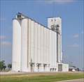
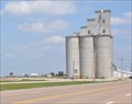
 view gallery view gallery SE2.3 km SE2.3 km
|   Dodge City Coop Elevator Haggard Dodge City Coop Elevator Haggard
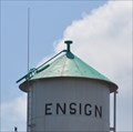
in Grain Elevators This Grain Elevator is located on the north side of US Highway 56 just east of Kansas Highway 23, about 5 miles west of Ensign, Kansas. posted by:  brwhiz brwhiz location: Kansas date approved: 02/08/2013 last visited: never |
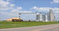
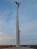 view gallery view gallery SW5.6 km SW5.6 km
|  Gray County Wind Farm - Montezuma, KS Gray County Wind Farm - Montezuma, KS
in Windmills Site of a windfarm and education kiosk on the Kansas Plains. posted by: Eagle1977 location: Kansas date approved: 10/12/2012 last visited: 08/26/2017 |
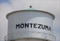
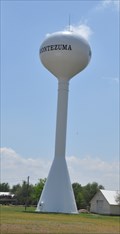 view gallery view gallerySW9.3 km |  Montezuma, Kansas Golf Ball Water Tower Montezuma, Kansas Golf Ball Water Tower
in Water Towers This modern spherical tank is located on the south side of US Highway 56 (Texcoco Street) just east of Mendoza Avenue. posted by: brwhiz location: Kansas date approved: 10/04/2012 last visited: 04/30/2012 |
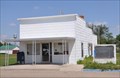
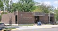
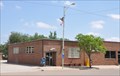 view gallery view gallerySW9.8 km |  Montezuma, Kansas 67867 Montezuma, Kansas 67867
in U.S. Post Offices This Post Office is located at 207 N Aztec Street in Montezuma, Kansas. posted by: brwhiz location: Kansas date approved: 09/01/2012 last visited: never |
 view gallery view gallery E9.8 km E9.8 km
| Ensign, Kansas 67841 in U.S. Post Offices This Post Office is located at 306 Aubrey Street in Ensign, Kansas. posted by: brwhiz location: Kansas date approved: 09/01/2012 last visited: never |
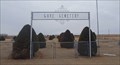
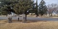
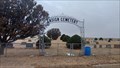 view gallery view galleryE9.8 km |  Ensign Cemetery - Ensign, KS Ensign Cemetery - Ensign, KS
in Worldwide Cemeteries This small rural cemetery is about a mile south of Ensign, Kansas. posted by: The Snowdog location: Kansas date approved: 11/20/2022 last visited: never |
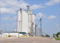 view gallery view gallerySW10 km | Grain Growers Co-Op Elevator ~ Montezuma, Kansas in Grain Elevators This elevator is located at 103 Texoco Street (US Highway 56) in Montezuma, Kansas. posted by: brwhiz location: Kansas date approved: 06/09/2012 last visited: never |
 view gallery view gallerySW10 km |  USCGS HH0888 ~ MONTEZUMA MUN WATER TANK USCGS HH0888 ~ MONTEZUMA MUN WATER TANK
in U.S. Benchmarks This surveyor's mark is the finial at the peak of the older-style water tower located on the south side of US Highway 56 (Texcoco Street) between Escalante and Alvarado Streets. posted by: brwhiz location: Kansas date approved: 10/04/2012 last visited: 09/23/2014 |
 view gallery view gallerySW10 km | Montezuma, Kansas Traditional Cylindrical Water Tower in Water Towers This is the older-style water tower located on the south side of US Highway 56 (Texcoco Street) between Escalante and Alvarado Streets. posted by: brwhiz location: Kansas date approved: 10/04/2012 last visited: 04/30/2012 |
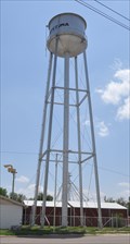
 view gallery view galleryE10.1 km | USCGS HH0880 ~ ENSIGN MUN WATER TANK in U.S. Benchmarks This surveyor's mark is the finial at the peak of the older-style water tower located on the south side of US Highway 56 (Bent Street) on the east side of Lamed Street in Ensign, Kansas. posted by: brwhiz location: Kansas date approved: 10/05/2012 last visited: 11/21/2022 |
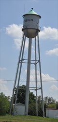 view gallery view galleryE10.1 km | Ensign, Kansas Water Tower in Water Towers This traditional cylindrical water tower is located on the south side of US Highway 56 (Bent Street) on the east side of Lamed Street in Ensign, Kansas. posted by: brwhiz location: Kansas date approved: 10/04/2012 last visited: 11/21/2022 |
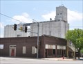
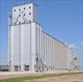 view gallery view galleryE10.5 km | Dodge City Coop Exchange Elevator in Grain Elevators This Grain Elevator is located on the north side of Bent Street (US Highway 56) just east of Leavenworth Street in Ensign, Kansas. posted by: brwhiz location: Kansas date approved: 02/08/2013 last visited: never |
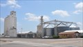
 view gallery view gallerySW10.5 km | Kansas Millers Elevator ~ Montezuma, Kansas in Grain Elevators The old Kansas Millers elevator is located on Texoco Street (US Highway 56) in the center of Montezuma, Kansas. posted by: brwhiz location: Kansas date approved: 06/09/2012 last visited: never |
 view gallery view gallerySW10.9 km | ADM Grain Elevator ~ Montezuma, Kansas in Grain Elevators This facility, operated by the ADM Grain Company, is located at 28605 12 Road in Montezuma, Kansas. posted by: brwhiz location: Kansas date approved: 06/09/2012 last visited: never |
 view gallery view gallerySE13.2 km | Cave Cemetery - Gray County, KS in Worldwide Cemeteries This rural cemetery is about six miles south of Ensign, Kansas. posted by: The Snowdog location: Kansas date approved: 11/20/2022 last visited: never |
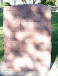
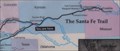
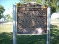 view gallery view gallery N17.7 km N17.7 km
|  The Santa Fe Trail - Gray County The Santa Fe Trail - Gray County
in Kansas Historical Markers This marker is in Cimarron Crossing Park about 1/2 mile south of Cimarron, Kansas on K-23. posted by: iconions location: Kansas date approved: 12/03/2008 last visited: 01/05/2023 |
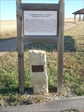
 view gallery view galleryN17.7 km |  Santa Fe Trail - Cimmaron, Kansas Trail Map Marker Santa Fe Trail - Cimmaron, Kansas Trail Map Marker
in Wagon Roads and Trails This is a red granite marker in Cimarron Crossing Park just south of Cimarron, Kansas on K-23. posted by: iconions location: Kansas date approved: 12/02/2008 last visited: 01/05/2023 |
 view gallery view galleryN17.7 km |  Cimarron Crossing Park - Cimarron, KS Cimarron Crossing Park - Cimarron, KS
in Municipal Parks and Plazas Constructed on the site of the historic Cimarron Ranch, Cimarron Crossings Park is part of the National Park Service - in Cimarron, Kansas. posted by: The Snowdog location: Kansas date approved: 01/07/2023 last visited: never |
 view gallery view galleryN17.7 km |  Cimarron Crossing Park - Cimarron, ,KS Cimarron Crossing Park - Cimarron, ,KS
in Public Playgrounds This beautiful park is managed by the City of Cimarron and by the National Park Service - in Cimarron, Kansas. posted by: The Snowdog location: Kansas date approved: 01/06/2023 last visited: never |
 view gallery view galleryN18.2 km | Irsik & Doll Grain Elevators ~ Cimarron, Kansas in Grain Elevators This multiple-elevator grain storage complex is located at 200 S Main Street, in Cimarron, Kansas. posted by: brwhiz location: Kansas date approved: 06/09/2012 last visited: 01/05/2023 |
 view gallery view galleryN18.3 km | Cimarron Co-Op Exchange Elevator ~ Cimarron, Kansas in Grain Elevators This older elevator, built sometime around 1950, is located at 122 S Main Street in Cimarron, Kansas. posted by: brwhiz location: Kansas date approved: 06/09/2012 last visited: 01/05/2023 |
 view gallery view galleryN18.7 km | Cimarron, Kansas 67835 in U.S. Post Offices This Post Office is located at 207 N Main Street in Cimarron, Kansas. posted by: brwhiz location: Kansas date approved: 09/01/2012 last visited: 01/05/2023 |
 view gallery view galleryN18.7 km | Cimarron Crossing - Cimarron, KS in Wagon Roads and Trails This marker indicates where the Santa Fe Trail crossed the Arkansas River - in Cimarron, Kansas. posted by: The Snowdog location: Kansas date approved: 01/05/2023 last visited: never |
 view gallery view gallery NE20.9 km NE20.9 km
| Santa Fe Trail - Campsite of US Survey Team 10-21Sep1825 in Wagon Roads and Trails Limestone marker with a brass plate and a wooden historical marker commemorating the Sibley Survey campsite of 10-21Sep1825. posted by: iconions location: Kansas date approved: 12/02/2008 last visited: 05/01/2020 |
 view gallery view galleryNE21.1 km |  Ft Larned, Santa Fe Trail, Howell, KS Ft Larned, Santa Fe Trail, Howell, KS
in 'You Are Here' Maps This "You Are Here" tells you that you are at the Santa Fe Trail. posted by: Queens Blessing location: Kansas date approved: 06/06/2010 last visited: 05/01/2020 |
|